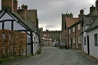
Great Budworth is a village and civil parish in Cheshire, England, four miles (6.4 km) north of Northwich off the A559 road, east of Comberbach, northwest of Higher Marston and southeast of Budworth Heath. Until 1948, Great Budworth was part of the Arley Hall estate.

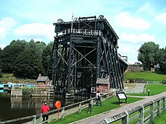
Marston is a village and civil parish in the unitary authority of Cheshire West and Chester, in the northwest of England. The settlement is on the River Weaver, close to Anderton and the Anderton Boat Lift. The nearest major settlement to Marston is Manchester, which lies 15 miles (24 km) to the northeast. It is the site of the Lion Salt Works, now an industrial museum.

The River Weaver is a river, navigable in its lower reaches, running in a curving route anti-clockwise across west Cheshire, northern England. Improvements to the river to make it navigable were authorised in 1720 and the work, which included eleven locks, was completed in 1732. An unusual clause in the enabling Act of Parliament stipulated that profits should be given to the County of Cheshire for the improvement of roads and bridges, but the navigation was not initially profitable, and it was 1775 before the first payments were made. Trade continued to rise, and by 1845, over £500,000 had been given to the county.

Northwich is a town and civil parish in the unitary authority of Cheshire West and Chester and the ceremonial county of Cheshire, England. It lies in the heart of the Cheshire Plain, at the confluence of the rivers Weaver and Dane. The town is about 18 miles (29 km) east of Chester, 15 miles (24 km) south of Warrington, 19 miles (31 km) south of Manchester and 12 miles (19 km) south of Manchester Airport. The population of the civil parish was 19,924 in 2011 and for the wider built-up area was 47,421. Northwich was named as one of the best places to live in the United Kingdom by The Sunday Times in 2014.

Vale Royal was, from 1974 to 2009, a local government district with borough status in Cheshire, England. It contained the towns of Northwich, Winsford and Frodsham.

A civil parish is a country subdivision, forming the lowest unit of local government in England. There are 333 civil parishes in the ceremonial county of Cheshire, most of the county being parished. At the 2001 census, there were 565,259 people living in 332 parishes, accounting for 57.5 per cent of the county's population.

Davenham is a rural village and civil parish approximately 3 kilometres (1.9 mi) south of the town of Northwich, part of the Borough of Cheshire West and Chester and the ceremonial county of Cheshire in England. It has a population of 5,655, reducing following reorganisation to 2,745 at the 2011 Census. The village is close to the A556 and A533 roads and both the River Dane and River Weaver. It is the birthplace of former marathon world record holder, Paula Radcliffe.

Marbury is a small village located at SJ560457 in the civil parish of Marbury cum Quoisley, within the unitary authority of Cheshire East and the ceremonial county of Cheshire, England. It is administered jointly with the adjacent civil parishes of Norbury and Wirswall. The village lies around 3 miles (5 km) north east of Whitchurch in Shropshire and 7 miles (11 km) south west of Nantwich in Cheshire. Nearby villages include Malpas, No Man's Heath, Norbury, Wirswall and Wrenbury. The civil parish borders Shropshire and covers 2,168 acres (877 ha); it also contains the small settlements of Hollins Lane, Marley Green and Quoisley, as well as parts of Hollyhurst and Willeymoor. The total population was just under 250 in 2001, and – combined with Wirswall – 352 in 2011.

Wrenbury is a village in the civil parish of Wrenbury cum Frith, the unitary authority of Cheshire East, and the ceremonial county of Cheshire, England. It lies on the River Weaver, around 8.5 miles south-west of Crewe.

Hartford is a village and civil parish in the unitary authority of Cheshire West and Chester and the ceremonial county of Cheshire, England. It lies at the intersection of the A559 road and the West Coast Main Line and is less than 2 miles (3.2 km) south west of the town of Northwich. It forms part of the Weaver Vale parliamentary constituency. According to the 2011 Census, the population of the parish was 5,558.

Lostock Gralam is a village and civil parish in Cheshire, England, east of Northwich. The civil parish also includes the small hamlet of Lostock Green. At the 2011 census, the population was 2,298.

Wirswall is a village and civil parish in the unitary authority of Cheshire East and the ceremonial county of Cheshire, England, located at SJ544441 near the Shropshire border, around 1½ miles north of Whitchurch. The historical township had an area of 973 acres (3.94 km2). The civil parish also includes the settlements of Bradeley Green, Wicksted and part of Willey Moor.

Norbury is a hamlet and civil parish in the unitary authority of Cheshire East and the ceremonial county of Cheshire, England. The parish lies on the boundary with Cheshire West and Chester, and also includes the small settlements of Gauntons Bank, Hurst Green, Swanwick Green, Norbury Common and Holtridge, with a total population of nearly 200 people in 2011. The hamlet of Norbury lies around 5 miles (8 km) north of Whitchurch in Shropshire. Nearby villages include No Man's Heath, Marbury and Wrenbury.

Marbury Country Park is a country park in Cheshire, England. It lies in the heart of Northwich Community Woodlands, an integral part of the Mersey Forest. Former industrial land is gradually being transformed to create a rich and green environment stretching from Marbury to Northwich.

Brereton is a civil parish in the unitary authority of Cheshire East and the ceremonial county of Cheshire, England. According to the 2001 census, the population of the entire civil parish was 1,012, increasing to 1,190 at the 2011 Census. Brereton is mentioned in the Domesday book as the Manor of Bretune. The civil parish includes the hamlets of Brereton Green, Brereton Heath, Smethwick Green, Medhurst Green, Sandlow Green and Davenport. It takes its name from Britonnic bre meaning a hill and reton meaning fern or ferns, thus "Fernhill".

Cheshire West and Chester is a unitary authority with borough status in the ceremonial county of Cheshire, England. It was established on 1 April 2009 as part of the 2009 local government changes, by virtue of an order under the Local Government and Public Involvement in Health Act 2007. It superseded the boroughs of Ellesmere Port and Neston and Vale Royal and the City of Chester; its council assumed the functions and responsibilities of the former Cheshire County Council within its area. The remainder of ceremonial Cheshire is composed of Cheshire East, Halton and Warrington.

Northwich Woodlands is an area of 373 hectares of publicly accessible countryside near Northwich in Cheshire, England. It comprises nine separate woods, country parks, lakes and parks, many of which are connected to each other via footpaths and other rights of way. Much of the land was formerly industrial and used for mining salt and manufacturing chemicals. The extraction of salt caused subsidence leading to the formation of pools known as flashes. The land became derelict during the 20th century as the salt industry contracted. Much of the area has now been reclaimed for the purposes of conservation and recreation and forms part of the Mersey Forest initiative.
The history of Northwich can be traced back to the Roman period. The area around Northwich has been exploited for its salt pans since this time. The town has been severely affected by salt mining with subsidence historically being a large issue. A programme of mine stabilisation has recently been undertaken.
Anderton with Marbury is a civil parish in Cheshire West and Chester, England, which contains the villages of Anderton and Marbury. The Trent and Mersey Canal runs through the parish. Also in the parish is the Anderton Boat Lift, a scheduled monument, which has been restored to carry boats from the canal down to the Weaver Navigation. In the parish are four buildings that are recorded in the National Heritage List for England as designated listed buildings, all of which are at Grade II. This grade is the lowest of the three gradings given to listed buildings and is applied to "buildings of national importance and special interest". The structures consist of a mill and the miller's house, a farmhouse, and a milepost on the canal.