
Austerson is a civil parish in the unitary authority of Cheshire East and the ceremonial county of Cheshire, England, lying immediately south of the town of Nantwich and north of the village of Audlem. Predominantly rural with scattered farms, the civil parish includes the small settlement of Old Hall Austerson at SJ656493, about two miles south of Nantwich centre. In 2001, the total population was a little under 150, increasing to 194 at the 2011 Census. Nearby villages include Broomhall Green, Hack Green, Hankelow, Sound Heath and Stapeley.

Bickley is a village in the parish of No Man's Heath and District in Cheshire West and Chester and Cheshire, England. According to the 2001 Census it had a population of 498, that reduced to 481 at the 2011 census. The parish included the villages of Bickley Town and Bickley Moss. Bickley was a township in the parish of Malpas. In 1866 Bickley became a civil parish and on 1 April 2015 it was abolished to form "No Mans Heath and District".

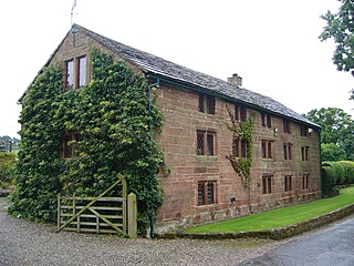
Broomhall is a civil parish in the unitary authority of Cheshire East and the ceremonial county of Cheshire, England. The main line of the Shropshire Union Canal runs through the parish and the River Weaver forms part of its boundary. The main settlement is the hamlet of Broomhall Green, which lies on the A530 about 3.5 miles (5.6 km) south-west of Nantwich. The civil parish has an area of 539 hectares, and also includes part of the small settlement of Sandford, with a total population of around 200 in 2011. Nearby villages include Aston, Sound, Wrenbury and Audlem. Broomhall appears in the Domesday survey and the name was also historically spelled Bromhall.

Wirswall is a village and former civil parish, now in the parish of Marbury and District, in the unitary authority area of Cheshire East and the ceremonial county of Cheshire, England, located at SJ544441 near the Shropshire border, around 1½ miles north of Whitchurch. The historical township had an area of 973 acres (3.94 km2). The civil parish also included the settlements of Bradeley Green, Wicksted and part of Willey Moor.

Norbury is a hamlet and former civil parish, now in the parish of Marbury and District, in the Cheshire East district, in the ceremonial county of Cheshire, England. It included the small settlements of Gauntons Bank, Hurst Green, Swanwick Green, Norbury Common and Holtridge, with a total population of nearly 200 people in 2011. The hamlet of Norbury lies around 5 miles (8 km) north of Whitchurch, Shropshire. Nearby villages include No Man's Heath, Marbury and Wrenbury.
Utkinton is a village and former civil parish, now in the parishes of Utkinton and Cotebrook, in the unitary authority area of Cheshire West and Chester and the ceremonial county of Cheshire, England. It is approximately 2 miles (3.2 km) north of Tarporley, 8 miles (13 km) west of Winsford and 9 miles (14 km) east of Chester. The upper part of Utkinton is known as 'Quarry Bank'. Utkinton is at the heart of the local farming community. The area is also on the Sandstone Trail.

St Peter's Church, Plemstall stands in an isolated position at the end of a country lane near the village of Mickle Trafford, Cheshire, England. It is recorded in the National Heritage List for England as a designated Grade I listed building. It is an active Anglican parish church in the diocese of Chester, the archdeaconry of Chester and the deanery of Chester. Its benefice is combined with that of St John the Baptist's Church, Guilden Sutton.
Faddiley is a small village and civil parish in the unitary authority of Cheshire East and the ceremonial county of Cheshire, England. The village is located 4 miles to the west of Nantwich. The parish also includes the small settlements of Larden Green and Woodhey or Woodhey Green, with a total population of just over 150, measured at 163 during the 2011 Census. Nearby villages include Brindley, Burland, Chorley, Haughton and Ravensmoor.
Mickle Trafford is a village and former civil parish, now in the parish of Mickle Trafford and District, in the unitary authority area of Cheshire West and Chester and the ceremonial county of Cheshire, England. It includes the area known as Plemstall. The A56 road from Chester to Warrington passes through the village and the Chester-Warrington railway line passes immediately to its east.
Bridge Trafford is a hamlet and former civil parish, now in the parish of Mickle Trafford and District, situated near to Chester, in the unitary authority of Cheshire West and Chester and ceremonial county of Cheshire, England. The hamlet lies some 2 miles (3 km) to the north of the centre of the village of Mickle Trafford on the A56 road. At the 2001 census it had a population of 33. The civil parish was abolished in 2015 to form Mickle Trafford and District.

Hoole Village is a village and former civil parish near Chester, in the unitary authority of Cheshire West and Chester and the ceremonial county of Cheshire, England. The civil parish was abolished in 2015 to form Mickle Trafford and District, part of it also went to Guilden Sutton. The parish contained the southern end of the M53 motorway where it becomes the A55 road and is crossed by the A56 road. This junction is known as Hoole Island Junction. Also in the village is Hoole Hall, which is now a hotel.

Lower Kinnerton is a village and former civil parish, now in the parish of Dodleston, in the unitary authority of Cheshire West and Chester and the ceremonial county of Cheshire, England, close to the England–Wales border. The neighbouring village of Higher Kinnerton is across the border in Flintshire. Lower Kinnerton is south of Broughton and to the north west of the village of Dodleston. It is a small agricultural community, which is also home to a local kennel and cattery business.

Wimbolds Trafford is a hamlet and former civil parish, now in the parish of Mickle Trafford and District, in the unitary authority area of Cheshire West and Chester and the ceremonial county of Cheshire, England. The hamlet lies on the B5132 road, approximately 5 miles (8 km) to the north east of Chester and north of the village of Mickle Trafford.

Huxley is a small rural village and former civil parish, now in the parish of Hargrave and Huxley, in the Cheshire West and Chester district, and ceremonial county of Cheshire in England. In 2001 the parish had a population of 220, increasing to 251 at the 2011 Census. The civil parish was abolished in 2015
Poulton is a settlement and former civil parish, now in the parish of Poulton and Pulford, in the Cheshire West and Chester, in the ceremonial county of Cheshire, England. In 2001 census the parish had a recorded population of 92.
Chorlton-by-Backford is a former civil parish, now in the parish of Backford, in Cheshire West and Chester, England. It contains four buildings that are recorded in the National Heritage List for England as designated listed buildings, all of which are at Grade II. This grade is the lowest of the three gradings given to listed buildings and is applied to "buildings of national importance and special interest". The parish is entirely rural, and the listed buildings are all domestic or related to farming.
Hapsford is a former civil parish, now in the parishes of Dunham-on-the-Hill and Hapsford and Manley, in Cheshire West and Chester, England. It contains three buildings that are recorded in the National Heritage List for England as designated listed buildings, all of which are at Grade II. This grade is the lowest of the three gradings given to listed buildings and is applied to "buildings of national importance and special interest". Apart from he village of Hapsford, the parish is entirely rural. All the listed buildings are domestic, or related to farming.
Hoole Village is a former civil parish, now in the parishes of Mickle Trafford and District and Guilden Sutton, in Cheshire West and Chester, England. It contains four buildings that are recorded in the National Heritage List for England as designated listed buildings, all of which are at Grade II. This grade is the lowest of the three gradings given to listed buildings and is applied to "buildings of national importance and special interest". The parish is located to the northeast of Chester, and contains only one substantial structure, Hoole Hall. This is a listed building, together with two associated structures. The only other listed building is a pinfold.
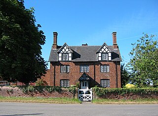
Mickle Trafford is a former civil parish, now in the parish of Mickle Trafford and District, in Cheshire West and Chester, England. It contains eleven buildings that are recorded in the National Heritage List for England as designated listed buildings. Of these, one is listed at Grade I, the highest grade, one is listed at Grade II*, the middle grade, and the others are at Grade II. Apart from the village of Mickle Trafford, the parish is rural. In addition to houses and buildings related to farming, the listed buildings include a medieval church and associated structures, an inscribed stone, and a corn mill.
Wimbolds Trafford is a former civil parish, now in the parish of Mickle Trafford and District, in Cheshire West and Chester, England. It contains five buildings that are recorded in the National Heritage List for England as designated listed buildings. Of these, one is listed at Grade II*, the middle grade, and the others are at Grade II. The parish is entirely rural. Its listed buildings consist of a former country house and its lodge, a cottage, a farmhouse, and farm buildings.

