
The Central Business District (CBD) is a neighborhood of the city of New Orleans, Louisiana, United States.

The Times-Picayune | The New Orleans Advocate is an American newspaper published in New Orleans, Louisiana, since January 25, 1837. The current publication is the result of the 2019 acquisition of The Times-Picayune by the New Orleans edition of The Advocate, which began publication in 2013 as a response to The Times-Picayune switching from a daily publication schedule to a Wednesday/Friday/Sunday schedule in October 2012.

Broadmoor is a neighborhood of the city of New Orleans. A subdistrict of the Uptown/Carrollton Area, its boundaries as defined by the City Planning Commission are: Eve Street to the north, Washington Avenue and Toledano Street to the east, South Claiborne Avenue to the south, and Jefferson Avenue, South Rocheblave Street, Nashville Avenue, and Octavia Street to the west. It includes the Broadmoor Historic District which was listed on the National Register of Historic Places in 2003 and increased in its boundaries in 2007.

Uptown is a section of New Orleans, Louisiana, United States, on the east bank of the Mississippi River, encompassing a number of neighborhoods between the French Quarter and the Jefferson Parish line. It remains an area of mixed residential and small commercial properties, with a wealth of 19th-century architecture. It includes part or all of Uptown New Orleans Historic District, which is listed on the National Register of Historic Places.

Gentilly is a broad, predominantly middle-class and racially diverse section of New Orleans, Louisiana. The Gentilly neighborhood is bounded by Lake Pontchartrain to the north, France Road to the east, Bayou St. John to the west, and the Louisville and Nashville Railroad to the south.
Rampart Street is a historic avenue located in New Orleans, Louisiana.

Lakeview is a neighborhood of the city of New Orleans. A subdistrict of the Lakeview District Area, its boundaries as defined by the City Planning Commission are: Robert E. Lee Boulevard to the north, Orleans Avenue to the east, Florida Boulevard, Canal Boulevard and I-610 to the south and Pontchartrain Boulevard to the west. Lakeview is sometimes used to describe the entire area bounded by Lake Pontchartrain to the north, the Orleans Avenue Canal to the east, City Park Avenue to the south and the 17th Street Canal to the west. This larger definition includes the West End, Lakewood and Navarre neighborhoods, as well as the Lakefront neighborhoods of Lakeshore and Lake Vista.

New Orleans East is the eastern section of New Orleans, the newest section of the city. It is bounded by the Industrial Canal, the Intracoastal Waterway and Lake Pontchartrain. Developed extensively from the 1950s onward, its numerous residential subdivisions and shopping centers offered suburban-style living within the city limits of New Orleans. Its overall character is decidedly suburban, resembling the archetypal postwar American suburb much more than the compactly-built environment found in the city's historic core.
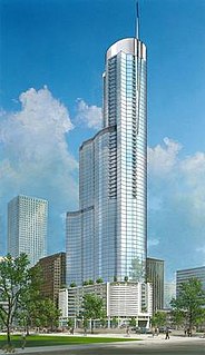
The Trump International Hotel and Tower was a proposed residential tower located in the Central Business District of New Orleans, Louisiana. It was a project of real estate mogul Donald Trump's Trump Organization. Supposedly in the planning stages from summer 2005 on, the project was finally declared dead in July 2011 after the location land was foreclosed on and sold at auction.
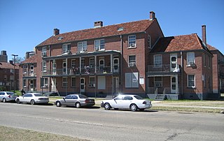
Iberville Projects was a neighborhood in the city of New Orleans and one of the low-income Housing Projects of New Orleans. The Iberville was the last of the New Deal-era public housing remaining in the city. Its boundaries were St. Louis Street, Basin Street, Iberville Street, and North Claiborne Avenue. It is located in the 6th ward of downtown New Orleans, on the former site of the Storyville district. The area has recently been redeveloped into a modernized apartment complex called the Bienville Basin Apartments.

Hollygrove is a neighborhood of the city of New Orleans, Louisiana, located in the city's 17th Ward. A subdistrict of the Uptown/Carrollton area, its boundaries as defined by the City Planning Commission are: Palmetto Street to the north, Cambronne, Edinburgh, Forshey, Fig and Leonidas Streets to the east, Earhart Boulevard to the south and the Jefferson Parish boundary to the west. Conrad playground, the Cuccia-Byrnes playground and Larry Gilbert baseball stadium are located in Hollygrove. The Hollygrove Market and Farm is also located in Hollygrove. Notable people, including rapper Lil Wayne, have grown up in the neighborhood.

The Hyatt Regency New Orleans is a 32-story, 361-foot -tall hotel located at 601 Loyola Ave in the Central Business District of New Orleans, Louisiana. It has 1,193 guest rooms, including 95 suites. It is part of a complex of connected buildings, which includes the Mercedes-Benz Superdome, 1250 Poydras Plaza, Entergy Tower, and the Benson Tower. Originally opened in 1976, it was designed by Welton Becket and Associates. It was severely damaged by Hurricane Katrina in 2005 and remained closed for six years, until 2011.

State Palace Theatre is a performing arts venue located in downtown New Orleans, Louisiana. It is located at the uptown lake corner of Canal Street and Rampart Street. The Saenger Theater is directly opposite the State Palace on Canal Street.

The Plaza Hotel is a former hotel building in College Station, Texas. The building contained 300 rooms and was 17 stories high. It was located at 410 South Texas Avenue, College Station, Texas 77840.
1031 Canal was a partially collapsed 190-foot-tall (58 m) multi-use high-rise building in New Orleans, Louisiana, located at 1031 Canal Street in the Central Business District. If completed, the project would have been known as the Hard Rock Hotel New Orleans.

The Joy Theater, named after owner Joy Houck, is a theater and historic landmark built in 1947 on Canal Street in downtown New Orleans, Louisiana. Renovations in 2011 transformed the former movie palace into a multi-purpose theater for live music, stand-up comedy, private functions, and corporate events. The theater's iconic marquee sign was restored, as was the building's original art deco architecture.

930 Poydras is a 21-story, 270.31-foot (82.4 m) residential skyscraper in New Orleans, Louisiana. Located on Poydras Street, the main thoroughfare in the city's Central Business District (CBD), it is the tallest building completed in the city in the 2010s and the first residential skyscraper completed in the city following Hurricane Katrina. Some sources affirm that the building was financed via Gulf Opportunity Zone financing that was enacted by the United States Congress to aid in the recovery from Katrina, while other sources state that alternative financing was used. The building's construction was the subject of a court battle regarding damage to surrounding buildings. Nonetheless, the building's design, which was scaled back from early plans, has won many awards.
William Nowland Tom Van Powell (1904-1977), sometimes known professionally as William Van Powell or Nowland Van Powell was an architect, painter, and historian from Memphis, Tennessee.
