Grant, Oklahoma

Last updated

Grant, Oklahoma
USA Oklahoma location map.svg
Red pog.svg
Grant
Location within the state of Oklahoma
Coordinates: 33°56′19″N95°30′56″W / 33.93861°N 95.51556°W / 33.93861; -95.51556
Country United States
State Oklahoma
County Choctaw
Area
[1]
  Total1.91 sq mi (4.95 km2)
  Land1.88 sq mi (4.86 km2)
  Water0.03 sq mi (0.08 km2)
Elevation
[2]
459 ft (140 m)
Population
 (2020)
  Total190
  Density101.17/sq mi (39.06/km2)
Time zone UTC-6 (Central (CST))
  Summer (DST) UTC-5 (CDT)
ZIP codes
74738
FIPS code 40-31000
GNIS feature ID2629920 [2]

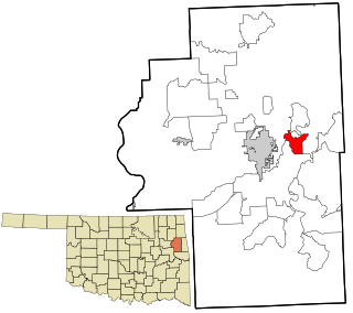
Grant is an unincorporated community in Choctaw County, Oklahoma, United States. [3] It is located along U.S. Route 271, south of Hugo. [4] As of the 2010 census it had a population of 289. [5]

Contents

History

The community was founded as a station stop on the St. Louis and San Francisco Railroad, which opened through the Indian Territory in June 1887. A post office opened at Grant, Indian Territory on January 31, 1889. It was named for President Ulysses S. Grant. [6]

At the time of its founding, Grant was located in Kiamitia County, a part of the Apukshunnubbee District of the Choctaw Nation. [7]

Demographics

Historical population
CensusPop.Note
2020 190
U.S. Decennial Census [8]

As of the 2010 Census, there were 289 people, 120 households, and 82 families residing in the community. [5] The racial composition of the city was 55.0% White, 23.9% African American, 9.3% Native American, 2.4% from other races, and 9.3% from two or more races. Hispanic or Latino of any race were 3.8% of the population. [5]

Of the 120 households, 30.8% had children under the age of 18 living with them, 45.0% were married couples living together, 18.3% had a female householder with no husband present, and 31.7% were non-families. [5] 29.2% of all households were made up of individuals, and 13.4% had someone living alone who was 65 years of age or older. [5] The average household size was 2.41 and the average family size was 2.85. [5]

In the city the population was spread out, with 21.8% under the age of 18, 10.0% from 18 to 24, 20.8% from 25 to 44, 29.4% from 45 to 64, and 18.0% who were 65 years of age or older. [9] The median age was 42.8 years. [9] For every 100 females, there were 88.9 males. For every 100 females age 18 and over, there were 85.2 males. [9]

According to the 2013 American Community Survey, the median income for a household in the city was $33,750 and the median income for a family was $43,942. [10] The per capita income for the city was $18,293. [10] About 6.9% of the population and 3.5% of families were below the poverty line, including 5.6% of those under age 18 and 25.0% of those age 65 or over. [10]

Notable people

Related Research Articles

<span class="mw-page-title-main">Coal County, Oklahoma</span> County in Oklahoma, United States

Coal County is a county located in the U.S. state of Oklahoma. As of the 2020 census, the population was 5,266. Its county seat is Coalgate.

<span class="mw-page-title-main">Bokchito, Oklahoma</span> Town in Oklahoma, United States

Bokchito is a town in Bryan County, Oklahoma, United States. The population was 632 at the 2010 census, an increase of 12.1 percent over the figure of 564 recorded in 2000. In the Choctaw language, "bok" means river, and "chito" means big or large, literally translating into "big creek".

<span class="mw-page-title-main">Tatums, Oklahoma</span> Town in Oklahoma, United States

Tatums is a historic Freedmen's town in Carter County, Oklahoma, United States. The population was 151 at the 2010 census, a decline of 12.2 percent from the figure of 172 in 2000. It is part of the Ardmore, Oklahoma Micropolitan Statistical Area.
<span class="mw-page-title-main">Briggs, Oklahoma</span> Census-designated place in Oklahoma, United States

Briggs is an unincorporated community and census-designated place (CDP) in Cherokee County, Oklahoma, United States. The population was 303 at the 2010 census.

<span class="mw-page-title-main">Eldon, Oklahoma</span> Census-designated place in Oklahoma, United States

Eldon is an unincorporated community and census-designated place (CDP) in Cherokee County, Oklahoma, United States. The population was 368 at the 2010 census, a loss of 62.3 percent from 991 at the 2000 census, due largely to shrinkage of the CDP boundaries. It lies east of Tahlequah at the junction of U.S. Highway 62 and State Highway 51. The Eldon Post Office existed from March 20, 1911, until May 30, 1936. The community is said to have been named for Eldon, Illinois.

<span class="mw-page-title-main">Boswell, Oklahoma</span> Town in Oklahoma, United States

Boswell is a town in Choctaw County, Oklahoma, United States. The population was 709 at the 2010 census.

<span class="mw-page-title-main">Swink, Oklahoma</span> Census-designated place in Oklahoma, United States

Swink is an unincorporated community and census-designated place (CDP) in Choctaw County, Oklahoma, United States. As of the 2010 census the population was 66. The population was 83 at the 2000 census, at which time it was a town; the community disincorporated on December 1, 2000.

Cayuga Springs is an unincorporated community and census-designated place (CDP) in Delaware County, Oklahoma, United States. The population was 140 at the 2010 census, a 33.3 percent increase over the figure of 105 recorded in 2000.

<span class="mw-page-title-main">Dennis, Oklahoma</span> Census-designated place in Oklahoma, United States

Dennis is an unincorporated community and census-designated place (CDP) in Delaware County, Oklahoma, near Grand Lake. The population was 195 at the 2010 census. The Dennis Post Office existed from March 25, 1914, until January 31, 1956. It is said to be named for a local resident, Peter Dennis.

<span class="mw-page-title-main">Dodge, Oklahoma</span> Census-designated place in Oklahoma, United States

Dodge is an unincorporated community and census-designated place (CDP) in Delaware County, Oklahoma, United States. The population was 115 at the 2010 census, up from the figure of 96 recorded in 2000.

<span class="mw-page-title-main">Leach, Oklahoma</span> Census-designated place in Oklahoma, United States

Leach is an unincorporated community and census-designated place (CDP) in southwestern Delaware County, Oklahoma, United States, along U.S. Route 412 and 412 Alternate. The population was 237 at the 2010 census.

<span class="mw-page-title-main">LeFlore, Oklahoma</span> Town in Oklahoma, United States

LeFlore is a town in LeFlore County, Oklahoma, United States. It is part of the Fort Smith, Arkansas-Oklahoma Metropolitan Statistical Area. The population was 190 at the 2010 census, an increase of 13.1 percent over the figure of 168 in 2000. Although the legal town name is spelled in the two-word form, the official federal name for the place and the postal name used is Leflore.

<span class="mw-page-title-main">Wister, Oklahoma</span> Town in Oklahoma, United States

Wister is a town in Le Flore County, Oklahoma, United States. It is part of the Fort Smith metropolitan area. The population was 1,102 at the 2010 census. Wister is named for Gutman G. Wister, an official with the Choctaw, Oklahoma and Gulf Railroad.

<span class="mw-page-title-main">Hartshorne, Oklahoma</span> City in Oklahoma, United States

Hartshorne is a city in Pittsburg County, Oklahoma, United States. It is the second largest city in the county. The population was 2,125 at the 2010 census.

<span class="mw-page-title-main">Bushyhead, Oklahoma</span> CDP in Oklahoma, United States

Bushyhead is a census-designated place (CDP) in Rogers County, Oklahoma, United States. The population was 1,314 at the 2010 census, a 9.2 percent increase over the figure of 1,203 recorded in 2000. Established on the St. Louis-San Francisco Railway between Claremore and Vinita, the community was named for Dennis W. Bushyhead, Principal Chief of the Cherokee, 1879–1887. The post office existed from April 18, 1898, until November 15, 1955.

<span class="mw-page-title-main">Long, Oklahoma</span> CDP in Oklahoma, United States

Long is a census-designated place (CDP) in Sequoyah County, Oklahoma, United States. It is part of the Fort Smith, Arkansas-Oklahoma Metropolitan Statistical Area. The population was 363 at the 2000 census.

Tiawah is a census-designated place (CDP) in Rogers County, Oklahoma, United States. The population was 189 at the 2010 census, a 13.9 percent gain over the figure of 166 recorded in 2000. It was built on the St. Louis, Iron Mountain, & Southern Railway line running from Coffeyville, Kansas, to Fort Smith, Arkansas. The post office existed from August 24, 1903, until December 31, 1938. It is said to be named for Tiawah Mound in Georgia.

<span class="mw-page-title-main">Kenton, Oklahoma</span> Town in Oklahoma, United States

Kenton, located in Cimarron County, Oklahoma, United States, is the westernmost town in Oklahoma. From Kenton, it is approximately 155 miles (249 km) south to Amarillo, Texas, 237 miles (381 km) northwest to Colorado Springs, Colorado, 306 miles (492 km) north-northwest to Denver, Colorado, 314 miles (505 km) southwest to Albuquerque, New Mexico, 340 miles (550 km) northeast to Wichita, Kansas, and 361 miles (581 km) southeast to Oklahoma City, the nearest major population centers.

<span class="mw-page-title-main">Sparrowhawk, Oklahoma</span> Census-designated place in Oklahoma, United States

Sparrowhawk is an unincorporated community and census-designated place (CDP) in Cherokee County, Oklahoma, United States. The population was 191 as of the 2010 census, at which time the CDP was known as Scraper. The older name of the community was given for Captain Archibald Scraper of the 2nd Regiment, Indian Home Guard. Sparrowhawk takes its name from Sparrow Hawk Mountain, which occupies most of the CDP.

<span class="mw-page-title-main">Norfolk (CDP), Connecticut</span> Census-designated place in Connecticut, United States

Norfolk is a census-designated place (CDP) in Litchfield County, Connecticut, United States. It is the central village within the town of Norfolk. As of the 2010 census, the population of the CDP was 553, out of 1,709 in the entire town.

References

  1. "ArcGIS REST Services Directory". United States Census Bureau. Retrieved September 20, 2022.
  2. 1 2 U.S. Geological Survey Geographic Names Information System: Grant, Oklahoma
  3. U.S. Geological Survey Geographic Names Information System: Grant, Oklahoma
  4. Knight, Janie."Grant," Encyclopedia of Oklahoma History and Culture, Oklahoma Historical Society, Accessed May 24, 2015.
  5. 1 2 3 4 5 6 "DP-1: Profile of General Population and Housing Characteristics: 2010 - 2010 Demographic Profile Data: Grant CDP, Oklahoma" Archived 2020-02-13 at archive.today American Fact Finder, United States Census Bureau, Accessed May 24, 2015.
  6. Shirk, George H. Oklahoma Place Names (Norman: University of Oklahoma Press, 1965), p. 92.
  7. Morris, John W. Historical Atlas of Oklahoma (Norman: University of Oklahoma Press, 1986), plate 38.
  8. "Census of Population and Housing". Census.gov. Retrieved June 4, 2016.
  9. 1 2 3 "QT-PI: Age Groups and Sex: 2010 - 2010 Census Summary File 1: Grant CDP, Oklahoma Archived 2020-02-13 at archive.today , American Fact Finder, United States Census Bureau, Accessed May 24, 2015.
  10. 1 2 3 "DP03: Selected Economic Characteristics - 2009-2013 American Community Survey 5-Year Estimates: Grant CDP, Oklahoma," Archived 2020-02-13 at archive.today American Fact Finder, United States Census Bureau, Accessed May 24, 2015.

Further reading