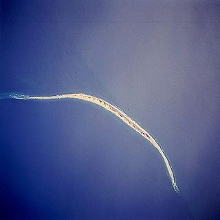
Graveyard of the Atlantic

Last updated

Graveyard of the Atlantic is a nickname for the treacherous waters and area of numerous shipwrecks off the Outer Banks of North Carolina, United States, which are due to the coast's shifting sands and inlets. To a lesser degree, this nickname has also been applied to Sable Island off of Nova Scotia, Canada, as well as the waters off Cape Cod, Massachusetts, United States.

Contents

Outer Banks

Line engraving published in "Harper's Weekly", 1863, depicting the USS Monitor sinking in a storm off Cape Hatteras on the night of 30-31 December 1862. USS Monitor - H58758.jpg
Line engraving published in "Harper's Weekly", 1863, depicting the USS Monitor sinking in a storm off Cape Hatteras on the night of 30–31 December 1862.

Along the Outer Banks, navigational challenges posed by the Diamond Shoals area off Cape Hatteras, caused the loss of thousands of ships and an unknown number of human lives. More than 5,000 ships have sunk in these waters since record-keeping began in 1526. [1] The Graveyard of the Atlantic Museum, located in Hatteras Village, focuses on the history of this area and features many artifacts recovered from area shipwrecks.

Among the better known shipwrecks were the USS Monitor, a participant in the famous Battle of Hampton Roads during the American Civil War, and the Patriot which carried Theodosia Burr Alston, Aaron Burr's daughter. [2] [3] The Monitor foundered and sank on December 31, 1862, off Cape Hatteras, while the Patriot presumably sank off the coast in January 1813. The first recorded shipwreck off the coast of North Carolina was in 1526 off the mouth of Cape Fear River. [4] The large numbers of explorers who came to the area in subsequent years had to travel through the rough waters to get to the coast of North Carolina. In June 1718, Edward Teach—better known as Blackbeard the pirate—ran his flagship, the Queen Anne's Revenge , aground near present-day Beaufort Inlet, NC. Thirty-two years later, in August 1750, at least three Spanish merchantmen ran aground off North Carolina during a hurricane: the El Salvador sank near Cape Lookout, while the Nuestra Señora de Soledad went ashore on near present-day Core Banks, and the Nuestra Señora de Guadalupe went ashore near present-day Ocracoke Island. [5] [6] Survivors of a much earlier shipwreck created the lost town of Wash Woods, Virginia using lumber that washed ashore. However, the extreme weather eventually claimed the town as well.

The Graveyard extends along the whole of the North Carolina coast, northward past Chicamacomico, Bodie Island, and Nags Head to Sandbridge Beach, and southward in curving arcs to the points at Cape Lookout and Cape Fear. [7] This spot is known as Cape Point, which is the stretch of beach that divides Hatteras Island's north- and south-facing beaches. It is a very famous spot on the east coast, despite its fragile location. Cape Hatteras has been a deadly trap for sailors that have entered over the centuries. The stretch of shore is home to more than 600 shipwrecks off the shifting sandbars of the Hatteras Islands. [4] The sandbars shift due to rough waves and unpredictable currents. Another danger was the Outer Banks "wreckers." Some residents of the Outer Banks, known as wreckers, made part of their living by scavenging wrecked ships—or by luring ships to their destruction. [8] Horses with a lantern tied to their neck would be walked along the beach. The lanterns' up and down motion would appear to other ships to represent clear water and a ship ahead. The unsuspecting captain would then drive his ship ashore following the false light. [9]

During World War II, German U-boats would sit offshore and prey on passing freighters and tankers silhouetted against the lights onshore. Hundreds of ships along the North Carolina coast were torpedoed by submarines in this fashion in what became known as Torpedo Alley. [9] In the twenty-first century, ships still have trouble in the area including the Bounty which sank off Cape Hatteras in 2012 due to Hurricane Sandy and a 72-foot fishing boat called the Ocean Pursuit which ran aground on Bodie Island in 2020. [10] [11]

Sable Island

The title "Graveyard of the Atlantic" is also applied to Sable Island, a narrow crescent of sand that lies 300 km southeast of Halifax, Nova Scotia. There have been over 350 recorded shipwrecks [12] since HMS Delight in 1583. [13]

People believe that the island was first discovered in the 1520s by the European explorer João Álvares Fagundes, who named it Fagundes, but the name was changed by the French at the end of the 16th century to île de Sable, which means Sand Island. The island is little more than a 40 km long sandbar, although it does have a number of fresh water ponds. [14] It is only 1.5 km wide at its widest; the highest point on the island is approx 30 metres tall.

Rev. Andrew Le Mercier was a French Huguenot priest from Boston who tried to colonize the island in 1738. [14] There are approximately 400–550 feral horses that are believed to be the descendants of survivors of those that were introduced by Le Mercier. These horses feed off the wild grass, plants and fresh water sources throughout the island. Sable Island is home to the largest grey seal colony in the world. [15] There are also many types of birds, including the Ipswich sparrow, who breeds only on Sable Island. In 2013, Sable Island was designated a National Park Reserve [16]

In the age of sail, the danger of Sable Island was due to the shifting sand bars that surround it, and the thick fog in the area due to the close proximity of the cold Labrador Current and warm Gulf Stream current. Ships were often pushed onto its shores during storms, resulting in a life-saving station being established there in 1801. [17] In 1872, the Canadian Government added two lighthouses [18] one on each end of island, which helped reduce the number of wrecks. The last shipwreck was the Merrimac, which occurred in 1999. With the many advances in modern navigation, the two lighthouses have been decommissioned.

Due to the strange (and mostly uninhabited) location of Sable Island, Guglielmo Marconi made it an outpost for radio communication experimentation. In 1901, Marconi thought this Atlantic island would be a good location for a wireless station for transatlantic communication. [19]

Cape Cod

Approximate locations of Cape Cod shipwrecks, as of 1903 Approximate Locations of Cape Cod Wrecks Down to 1903.jpg
Approximate locations of Cape Cod shipwrecks, as of 1903

The Lower Cape and Outer Cape sections of Cape Cod have also sometimes been called The Graveyard of the Atlantic or similar appellations. [20] About 3,000 shipwrecks have occurred there in recorded history. [21]

See also

Related Research Articles

<span class="mw-page-title-main">Sable Island</span> Place in Nova Scotia, Canada

Sable Island is a small Canadian island situated 300 km (190 mi) southeast of Halifax, Nova Scotia, and about 175 km (109 mi) southeast of the closest point of mainland Nova Scotia in the North Atlantic Ocean. The island is staffed year round by three federal government staff, rising during summer months when research projects and tourism increase. Notable for its role in early Canadian history and the Sable Island horse, the island is protected and managed by Parks Canada, which must grant permission prior to any visit. Sable Island is part of District 7 of the Halifax Regional Municipality in Nova Scotia. The island is also a protected National Park Reserve and an Important Bird Area.

<span class="mw-page-title-main">Cape Hatteras</span> Cape on the shoreline of Hatteras Island, North Carolina, United States

Cape Hatteras is a cape located at a pronounced bend in Hatteras Island, one of the barrier islands of North Carolina.

<span class="mw-page-title-main">Cape Hatteras Lighthouse</span> Lighthouse in North Carolina, United States

Cape Hatteras Light is a lighthouse located on Hatteras Island in the Outer Banks in the town of Buxton, North Carolina and is part of the Cape Hatteras National Seashore. The lighthouse's semi-unique pattern makes it easy to recognize and famous. It is often ranked high on lists of most beautiful, and famous lighthouses in the US.

<span class="mw-page-title-main">Hatteras, North Carolina</span> Census-designated place in North Carolina, United States of America

Hatteras is an unincorporated village and census-designated place (CDP) in Dare County, North Carolina, United States, on the Outer Banks island of Hatteras, at its extreme southwestern tip. As of the 2010 census it had a population of 504. Immediately to the west of the village of Hatteras is Hatteras Inlet which separates Hatteras Island from the neighboring Ocracoke Island. North Carolina Highway 12 passes through the community linking it to Frisco to the east and Ocracoke to the west.

<i>Carroll A. Deering</i> Five-masted commercial schooner and ghost ship

The Carroll A. Deering was an American five-masted commercial schooner launched in 1919 and found run aground without its crew off Cape Hatteras, North Carolina, in January 1921.
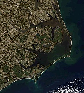
<span class="mw-page-title-main">Outer Banks</span> Barrier islands in North Carolina, United States

The Outer Banks are a 200 mi (320 km) string of barrier islands and spits off the coast of North Carolina and southeastern Virginia, on the east coast of the United States. They line most of the North Carolina coastline, separating Currituck Sound, Albemarle Sound, and Pamlico Sound from the Atlantic Ocean. A major tourist destination, the Outer Banks are known for their wide expanse of open beachfront and the Cape Hatteras National Seashore. The seashore and surrounding ecosystem are important biodiversity zones, including beach grasses and shrubland that help maintain the form of the land.

<span class="mw-page-title-main">Theodosia Burr Alston</span> American socialite, daughter of Aaron Burr (1783–1813)

Theodosia Burr Alston was an American socialite and the daughter of the third U.S. Vice President, Aaron Burr, and Theodosia Bartow Prevost. Her husband, Joseph Alston, was governor of South Carolina during the War of 1812. She was lost at sea at age 29.
<span class="mw-page-title-main">Hurricane Bertha (1990)</span> Category 1 Atlantic hurricane in 1990

Hurricane Bertha caused minor damage in the United States, Bermuda, and Atlantic Canada in July and August 1990. The third tropical cyclone, second named storm, and first hurricane of the 1990 Atlantic hurricane season, Bertha developed from a frontal low pressure area offshore of North Carolina on July 24. Initially subtropical, it slowly acquired tropical characteristics while tracked southeast and then southwestward. By early on July 27, the cyclone was re-classified as a tropical depression. Following its transition, the depression intensified and was upgraded to Tropical Storm Bertha on July 28. The storm then curved northeastward and rapidly strengthened. Bertha became a hurricane early on July 29, though it weakened back to a tropical storm later that day. On the following day, Bertha re-intensified into a hurricane and peaked as an 80 mph (130 km/h) Category 1 hurricane on July 31.

<span class="mw-page-title-main">North Carolina Maritime Museum</span>

The North Carolina Maritime Museum is a system of regional museums within the North Carolina Museum of History, which in turn part of the North Carolina Department of Natural and Cultural Resources. There are several branches of the Maritime Museum located in Beaufort, Southport and Hatteras.

Bodie Island is a long, narrow barrier peninsula that forms the northernmost portion of the Outer Banks. The land that is most commonly referred to as Bodie Island was at one time a true island, but in 1811 Roanoke Inlet, which had separated it from the Currituck Banks in the north, closed. As a result, the Currituck Banks and Bodie Island are now one contiguous peninsula, joined at the Nags Head area, where the inlet once flowed. Today, either name can be used to refer to the peninsula as a whole, but both portions colloquially retain their historical names.

<span class="mw-page-title-main">Graveyard of the Atlantic Museum</span> Museum in North Carolina

The Graveyard of the Atlantic Museum is a maritime museum that focuses on the maritime history and shipwrecks of the Outer Banks of North Carolina. The museum is located in Hatteras Village, the southernmost community on Hatteras Island, North Carolina, and opened in 2002.

<span class="mw-page-title-main">Hurricane How</span> Category 2 Atlantic hurricane in 1951

Hurricane How was the only tropical cyclone to make landfall on the United States in 1951. It was the eighth storm of the season, forming on September 28 in the northwest Caribbean and, after entering the Gulf of Mexico, turned eastward and became a tropical storm. The storm brought heavy rainfall to Florida, causing flooding and $2 million in damage. Tropical Storm How later became a hurricane, passing near the Outer Banks of North Carolina where it produced strong winds and high tides. A ship called the "Southern Isles" capsized off Cape Hatteras, killing 17 out of the crew of 23. Rains and high tides occurred in southeastern New England, before the hurricane moved out to sea and became extratropical.

<span class="mw-page-title-main">Coquina Beach</span> Beach in North Carolina, US

Coquina Beach is a beach in North Carolina, US, located in the Cape Hatteras National Seashore. It is located not far from the Wright Brothers National Memorial and is off highway 12 at milepost 22, 8 miles (13 km) south of Nags Head, North Carolina. Local activities include swimming, crabbing, surf fishing, surfing, shell collecting, bird and wildlife watching and sightseeing. Coquina Beach is considered by many visitors to be among the loveliest beaches in the Outer Banks. The beach is named for the tiny Coquina clams which abound in the margin.
<span class="mw-page-title-main">Benjamin B. Dailey</span> US keeper of lifeboat stations (1844–1914)

Benjamin Baxter Dailey (1844-1914) was the keeper of several lifeboat stations for the United States Life-Saving Service—one of the precursor services to the United States Coast Guard.

<span class="mw-page-title-main">Wreck of the Ephraim Williams</span>

The Ephraim Williams was a sailing ship wrecked off the coast of Hatteras Island, North Carolina, during a late December storm, late in 1884. The rescue of the barkentine's crew by Benjamin B. Dailey and his six oarsmen of the United States Lifesaving Service was considered particularly heroic, and the rescue is celebrated to the present day.

Delight was an English sailing ship that ran aground off Sable Island, while she was on Sir Humphrey Gilbert's expedition with HMS Squirrel to Newfoundland in North America.

The 1842 Atlantic hurricane season featured several maritime catastrophes in the Gulf of Mexico and along the U.S. East Coast, and produced one of the only known tropical cyclones to directly affect the Iberian Peninsula. As the season falls outside the scope of the Atlantic hurricane database, records of most storms in 1842 are scarce, and only approximate tracks are known. The first documented storm of the season battered the coast of North Carolina in mid-July, wrecking dozens of ships and destroying homes along the Outer Banks. A little over a month later, another storm impacted the same region and caused several more shipwrecks that killed at least 12 men. This storm later doused the Mid-Atlantic states with flooding rains. In early September, a powerful storm known as "Antje's Hurricane"—named after a ship that it dismasted—tracked generally westward after first being spotted over the Leeward Islands. After yielding widespread destruction across the Bahamas, the storm traversed the Florida Straits, causing severe damage in both northern Cuba and the lower Florida Keys. Many ships and their crews were lost to the storm as it crossed the Gulf of Mexico; it finally struck northern Mexico on September 8.

<i>Racer</i><span class="nowrap" style="padding-left:0.1em;">s</span> hurricane Category 4 Atlantic hurricane in 1837

Racer's hurricane was a destructive tropical cyclone that had severe effects in northeastern Mexico, the Republic of Texas, and the Gulf Coast of the United States in early October 1837. It was named after the Royal Navy ship HMS Racer, which encountered the cyclone in the northwestern Caribbean. Termed "one of the most famous and destructive hurricanes of the century" by meteorology historian David Ludlum, the storm first affected Jamaica with flooding rainfall and strong winds on September 26 and 27, before entering the Gulf of Mexico by October 1. As the hurricane struck northern Tamaulipas and southern Texas, it slowed to a crawl and turned sharply northeastward. The storm battered the Gulf Coast from Texas to the Florida Panhandle between October 3 and 7. After crossing the Southeastern United States, it emerged into the Atlantic shipping lanes off the Carolinas by October 9.

The 1827 North Carolina hurricane caused severe impacts along its track through the northeastern Caribbean Sea and up the East Coast of the United States in late August 1827. First observed over the Leeward Islands on August 17, the storm continued northwest, passing over Puerto Rico and the northern coastline of Hispaniola. It moved through the Turks and Caicos Islands and then the Bahamas by August 21 and curved northward. Although there is some discrepancy in its track, the hurricane moved ashore somewhere along the North Carolina coastline on August 25, perhaps at Category 4 intensity on the modern-day Saffir–Simpson hurricane wind scale. The cyclone emerged back into the Atlantic Ocean around Norfolk, Virginia, and grazed the New England coastline before last being observed offshore Nova Scotia on August 28. Along its track, numerous vessels were damaged, capsized, or run aground. The combination of heavy rainfall and ferocious winds caused severe crop damage, damaged or destroyed structures, and snapped and uprooted trees. Overall, the storm was responsible for more than six deaths and at least two injuries.

References

  1. Grussing, Valerie J. "Reanimating the Graveyard: Heritage Tourism Development of North Carolina Shipwrecks" (PDF). thescholarship.ecu.edu. Retrieved 18 July 2015.
  2. "NOAA's National Ocean Service".
  3. Ingram, Hunter. "Lost at sea? The tragic mystery of Theodosia Burr Alston". Wilmington Star News. Retrieved 2020-07-26.
  4. 1 2 (2008). Graveyard of the Atlantic. http://www.ncbeaches.com/Features/History/GraveyardOfTheAtlantic
  5. "North Carolina Shipwrecks: The Spanish Galleons ~ 18 August 1750". 6 January 2012.
  6. "El Salvador". Intersal, Inc.
  7. Stick, D. (1981). Graveyard of the Atlantic. North Carolina, The University of North Carolina.
  8. "Archived copy". Archived from the original on 2016-04-05. Retrieved 2015-03-26.{{cite web}}: CS1 maint: archived copy as title (link)
  9. 1 2 Hopewell, John (September 13, 2016). "These Ships are Resting Just Off the Outer Banks in the Graveyard of the Atlantic". The Washington Post .
  10. Morgenstein, Mark (30 October 2012). "Famed ship sinks off North Carolina; two crew missing". CNN . Retrieved 2012-10-29.
  11. "Fishing Boat Slowly Sinking Into the Sand After Running Aground off North Carolina's Outer Banks". The Weather Channel. Retrieved 2020-07-26.
  12. "Maritime Museum of the Atlantic – Sable Island". 14 February 2013.
  13. "Marine Heritage Database: HMS Delight".
  14. 1 2 Keddy, V (2008). Mysteries of Canada. http://www.mysteriesofcanada.com/Nova_Scotia/sable_island.htm
  15. "The Nature of Things".
  16. "Parks Canada". 16 October 2020.
  17. "A Brief History of Sable Island".
  18. "Lighthouses of Nova Scotia".
  19. "National Marconi Day". Facebook . Archived from the original on 2022-02-26.
  20. "Cape Cod's reputation as a graveyard of menace to mariners". Cape Cod Times. August 22, 1999. Retrieved April 25, 2024.Amy Whorf McGuiggan (May 19, 2021). "A Life-Saving Beacon in the Fog of Politics". Provincetown Independent. Retrieved April 25, 2024. "Maritime History at Cape Cod National Seashore". United States National Park Service. Retrieved April 25, 2024. "The "Ocean Graveyard" is Filled With Cape Cod Shipwrecks". CapeCod.com. February 4, 2019. Retrieved April 25, 2024.Catherine Kozak (March 8, 2010). "What's in a name? - Graveyard of the Atlantic". Virginia-Pilot. Retrieved April 25, 2024. "Graveyard of the Atlantic". Wanderlust Tours. Retrieved April 25, 2024.Burbank, Theodore Parker (2013). Cape Cod Shipwrecks: Graveyard of the Atlantic. Parker Nelson Publishing. ISBN   978-1935616078.
  21. "Lifesavers". United States National Park Service. Retrieved April 25, 2024.
Listen to this article (1 minute)
Sound-icon.svg
This audio file was created from a revision of this article dated 10 December 2005 (2005-12-10), and does not reflect subsequent edits.