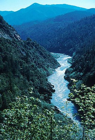
The Klamath River flows 257 miles (414 km) through Oregon and northern California in the United States, emptying into the Pacific Ocean. By average discharge, the Klamath is the second largest river in California after the Sacramento River. It drains an extensive watershed of almost 16,000 square miles (41,000 km2) that stretches from the arid country of south-central Oregon to the temperate rainforest of the Pacific coast. Unlike most rivers, the Klamath begins in the high desert and flows toward the mountains – carving its way through the rugged Cascade Range and Klamath Mountains before reaching the sea. The upper basin, today used for farming and ranching, once contained vast freshwater marshes that provided habitat for abundant wildlife, including millions of migratory birds. Most of the lower basin remains wild, with much of it designated wilderness. The watershed is known for this peculiar geography, and the Klamath has been called "a river upside down" by National Geographic magazine.

The Williamson River of south-central Oregon in the United States is about 100 miles (160 km) long. It drains about 3,000 square miles (7,800 km2) east of the Cascade Range. Together with its principal tributary, the Sprague River, it provides over half the inflow to Upper Klamath Lake, the largest freshwater lake in Oregon. The lake's outlet is the Link River, which flows into Lake Ewauna and the Klamath River.
The Little Deschutes River is a tributary of the Deschutes River in the central part of the U.S. state of Oregon. It is about 105 miles (169 km) long, with a drainage basin of 1,020 square miles (2,600 km2). It drains a rural area on the east side of the Cascade Range south of Bend. The Little Deschutes and two other streams in its basin are listed as parts of the National Wild and Scenic Rivers System.
The Alvord cutthroat trout, Oncorhynchus clarki alvordensis, was a subspecies of cutthroat trout. It was known only from Trout Creek in Oregon and Virgin Creek in Nevada, although it may have lived in several of the larger Alvord Basin streams during recent times. It was native to spring-fed creeks that ran down to Alvord Dry Lake in southeast Oregon, which was a large lake during the ice ages and an isolated drainage, part of the Great Basin today. This is one of the two cutthroat trout taxa considered extinct because all known populations are hybridized with rainbow trout which were introduced into streams in the Alvord basin in the 1920s, resulting in cutbows.

Redband trout are a group of three recognized subspecies of rainbow trout. They occur in three distinct regions in Pacific basin tributaries and endorheic basins in the western United States. The three subspecies are the Columbia River redband trout, the McCloud River redband trout and the Great Basin redband trout.

Malheur National Wildlife Refuge is a National Wildlife Refuge located roughly 30 miles (48 km) south of the city of Burns in Oregon's Harney Basin. Administered by the United States Fish and Wildlife Service, the refuge area is roughly T-shaped with the southernmost base at Frenchglen, the northeast section at Malheur Lake and the northwest section at Harney Lake.
The Fremont–Winema National Forest is a United States National Forest formed from the 2002 merger of the Fremont and Winema National Forests. They cover territory in southern Oregon from the crest of the Cascade Range on the west past the city of Lakeview to the east. The northern end of the forests is bounded by U.S. Route 97 on the west and Oregon Route 31 on the east. To the south, the state border with California forms the boundary of the forests. Klamath Falls is the only city of significant size in the vicinity. The forests are managed by the United States Forest Service, and the national forest headquarters are located in Lakeview.
The Donner und Blitzen River is a river on the eastern Oregon high desert that drains a relatively arid basin, the southern portion of Harney Basin, from roughly 20 to 80 miles south-southeast of Burns including Malheur National Wildlife Refuge. Though much of its course is marsh, it offers scenic glaciated canyons, unique ecosystems, and exceptional wild trout fisheries. Named by soldiers of German origin, the Donner und Blitzen River translates as "thunder and lightning". The name usually brings to mind two of Santa Claus's reindeer, but the river is named for a thunderstorm the soldiers experienced as they crossed the river; dry lightning is an almost daily occurrence in the region during certain times of the year.

The Klamath Basin is the region in the U.S. states of Oregon and California drained by the Klamath River. It contains most of Klamath County and parts of Lake and Jackson counties in Oregon, and parts of Del Norte, Humboldt, Modoc, Siskiyou, and Trinity counties in California. The 15,751-square-mile (40,790 km2) drainage basin is 35% in Oregon and 65% in California. In Oregon, the watershed typically lies east of the Cascade Range, while California contains most of the river's segment that passes through the mountains. In the Oregon-far northern California segment of the river, the watershed is semi-desert at lower elevations and dry alpine in the upper elevations. In the western part of the basin, in California, however, the climate is more of temperate rainforest, and the Trinity River watershed consists of a more typical alpine climate.

Malheur Lake is one of the lakes in the Malheur National Wildlife Refuge in Harney County in the U.S. state of Oregon. Located about 18 miles (29 km) southeast of Burns, the lake is marsh fed by the Donner und Blitzen River from the south and the Silvies River from the north. Malheur Lake periodically overflows into Mud Lake to the west and thence to Harney Lake, the sink of Harney Basin.
Harney Lake is a shallow alkali lake basin located in southeast Oregon, United States, approximately 30 miles (48 km) south of the city of Burns. The lake lies within the boundary of the Malheur National Wildlife Refuge and is the lowest point in the Blitzen Valley drainage.

Agency Lake is a natural lake located west of Chiloquin in Klamath County, Oregon. It is actually the northern arm of Upper Klamath Lake, connected by a narrow channel. Its primary inflow is the Wood River, while its outflow is Upper Klamath Lake. The lake has a surface area of approximately 9,000 acres (36 km2). The lake is very shallow, and experiences high winds. [Modoc Point Road] runs along the east side. Agency Lake Resort is located on the east side of the lake.

The Chewaucan River is part of the Great Basin drainage. It flows 53 miles (85 km) through the Fremont–Winema National Forests, Bureau of Land Management land, and private property in southern Oregon. Its watershed consists of 651 square miles (1,690 km2) of conifer forest, marsh, and rural pasture land. The river provides a habitat for many species of wildlife, including native Great Basin redband trout, a subspecies of rainbow trout.

Jackson F. Kimball State Recreation Site is a state park in southern Oregon. The park is operated and maintained by the Oregon Parks and Recreation Department, and is located approximately 20 miles (32 km) southeast of Crater Lake National Park and 3 miles (4.8 km) north of Fort Klamath. The park was established in 1955, and covers 19 acres (7.7 ha) including the headwaters of the Wood River.

Collier Memorial State Park is a state park in southern Oregon. The park is operated and maintained by the Oregon Parks and Recreation Department. It is located on U.S. Highway 97, approximately 30 miles (48 km) north of Klamath Falls and 105 miles (169 km) south of Bend. The park covers 146 acres (59 ha) along the Williamson River.

The Wood River is a short river in the southern region of the U.S. state of Oregon, and part of the Klamath Basin drainage. It flows 18 miles (29 km) through the Fremont-Winema National Forests, Bureau of Land Management land, and private property in southern Oregon. Its watershed consists of 220 square miles (570 km2) of conifer forest, rural pasture land, and marsh. The river provides habitat for many species of wildlife including an adfluvial (migratory) and resident populations of native Great Basin redband trout.

Little Blitzen River is a 12.5-mile (20.1 km) tributary of the Donner und Blitzen River in the U.S. state of Oregon. Little Blitzen River rises on the west flank of Steens Mountain about 20 miles (32 km) southeast of Frenchglen and about 70 miles (110 km) south of Burns in Harney County. Flowing west in a steep-walled canyon, it joins the South Fork Donner und Blitzen River at 42.6737752°N 118.7935277°W to form the Donner und Blitzen main stem, which continues north about another 40 miles (64 km) to its mouth at 43.291542°N 118.8199273°W in Malheur Lake. The Donner und Blitzen River was named by soldiers of German origin and translates as "thunder and lightning". Little Blitzen River brings to mind one of Santa Claus's reindeer.

The Goose Lake Valley is located in south-central Oregon and northeastern California in the United States. It is a high valley at the northwestern corner of North America's Great Basin. Much of the valley floor is covered by Goose Lake, a large endorheic lake that straddles the Oregon–California border. Native Americans inhabited the Goose Lake Valley for thousands of years before explorers arrived in the 19th century. The pioneer wagon route known as the Applegate Trail crossed the Goose Lake Valley on its way to southern Oregon. At the south end of Goose Lake, the Lassen Cutoff separated from the Applegate Trail and headed south toward the Sacramento Valley. Today, Lakeview, Oregon, is the largest settlement in the valley. Livestock ranching and lumber mills are the valley's main commercial activity. The Goose Lake Valley offers a number of recreational opportunities including hang-gliding, hunting, fishing, and birdwatching.
Lake of the Woods is a natural lake near the crest of the Cascade Range in the Fremont–Winema National Forest in southern Oregon in the United States. The lake covers 1,146 acres (4.64 km2). It was named by Oliver C. Applegate in 1870. Today, the Oregon Department of Fish and Wildlife manages the lake's fishery. The small unincorporated community of Lake of the Woods is located on the east shore of the lake. Lake of the Woods is one of southern Oregon's most popular outdoor recreation sites.

Miller Creek is a 7.6-mile-long (12.2 km) stream in western Klamath County, Oregon, United States. It originates above Gerber Reservoir and empties into irrigation canals within Langell Valley southeast of Bonanza and finally into the Lost River.