Harold Wood is a suburban neighbourhood of Romford in the London Borough of Havering. It is situated 16.5 miles (26.6 km) east-northeast of Charing Cross and near to the Greater London boundary with Essex.

Thurrock is a unitary authority area with borough status and unparished area in the ceremonial county of Essex, England. It is part of the London commuter belt and an area of regeneration within the Thames Gateway redevelopment zone. The local authority is Thurrock Council.

Basildon is the largest town in the borough of Basildon, within the county of Essex, England. It had a recorded population of 107,123. In 1931, the town had a population of 1,159.

Billericay is a town and civil parish in the Borough of Basildon, Essex, England. It lies within the London Basin and constitutes a commuter town 25 miles east of Central London. The town has three secondary schools and a variety of open spaces. It is thought to have been occupied since the Bronze Age.

The Borough of Basildon is a local government district in south Essex in the East of England, centred on the town of Basildon. It was formed as the Basildon District on 1 April 1974 from the former area of Basildon Urban District and the part of Thurrock Urban District that was within the Basildon New Town. The population of the district as of 2010 is about 172,000. The local authority is Basildon Borough Council. The council made an application for borough status in February 2010 and this was given approval that year, with Mo Larkin becoming the first mayor in October.
South Ockendon is a town, former civil parish and Church of England parish within the Thurrock borough in Essex in the East of England, United Kingdom. It is located on the border with Greater London, just outside the M25 motorway. The area to the north is North Ockendon. In 2019 it had an estimated population of 22,303 and in the 2021 United Kingdom census it had a population of 22,442 In 1931 the parish had a population of 1355.

Billericay was a constituency represented in the House of Commons of the Parliament of the United Kingdom. It elected one Member of Parliament (MP) by the first past the post system of election.

Basildon and Billericay is a constituency in Essex represented in the House of Commons of the UK Parliament. Since its 2010 creation it has been represented by John Baron, a Conservative.

Barstable was a Hundred in the English County of Essex. Both the hundred and the manor with the same name are mentioned in the Domesday Book of 1086. A number of parishes in the western part of the Barstable hundred are now in Thurrock.

Thurrock was a local government district and civil parish in south Essex, England from 1936 to 1974.

The River Crouch is a small river that flows entirely through the English county of Essex.

Great Burstead is an urban settlement in Essex, England - it is contiguous with the town of Billericay.
Basildon Urban District was a local government district in south Essex, England from 1934 to 1974.
Billericay Rural District was a local government district in Essex, England from 1894 to 1934.

Laindon is a commuter town in Essex, between Basildon and West Horndon. It was an ancient parish in Essex, England, that was abolished for civil purposes in 1937. It was based on the manor of the same name and now lies mostly within the urban area of Basildon.
Langdon Hills is a township and former civil parish located in Basildon in Essex, England.
Little Burstead is a village in Essex, England. It lies 2¼ miles SSW of Billericay, and 4½ E by S of Brentwood railway station.

The 1998 Basildon District Council election took place on 7 May 1998 to elect members of Basildon District Council in Essex, England. One third of the council was up for election and the Labour party stayed in overall control of the council.

The 2000 Basildon District Council election took place on 4 May 2000 to elect members of Basildon District Council in Essex, England. One third of the council was up for election and the Labour party lost overall control of the council to no overall control.
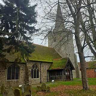
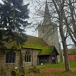
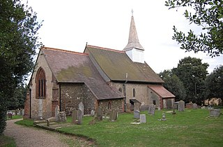
St Mary Magdalene is a Grade I-listed parish church in the village of Great Burstead, about 1.5 mi (2.4 km) south of Billericay, Essex, England. The present building dates to the 12th century, but a wooden church may have been built on the site during the seventh century. The church is part of the Great Burstead Conservation Area, which was designated as such in 1983.