Great Nicobar Island

Last updated

Great Nicobar
Native name:
Tokieong Long
India Andaman and Nicobar Islands location map.svg
Red pog.svg
Great Nicobar
Location of Great Nicobar Island in the Andaman and Nicobar Islands
Bay of Bengal location map simple.svg
Red pog.svg
Great Nicobar
Great Nicobar (Bay of Bengal)
Geography
Location Bay of Bengal
Coordinates 7°02′N93°48′E / 7.03°N 93.8°E / 7.03; 93.8
Archipelago Nicobar Islands
Adjacent to Indian Ocean
Total islands1
Major islands
  • Great Nicobar
Area921 km2 (356 sq mi) [1]
Coastline202 km (125.5 mi)
Highest elevation642 m (2106 ft)
Highest point Mount Thullier
Administration
Flag of India.svg  India
District Nicobar
Island group Nicobar Islands
Subdivisions of India Great Nicobar Subdivision
Taluk Split between Little Nicobar and Campbell Bay Taluk
Largest settlement Campbell Bay (pop. 5,740)
Demographics
Population8,067 (2014)
Pop. density8.8/km2 (22.8/sq mi)
Ethnic groups Hindustani, Nicobarese, Shompen, Malay
Additional information
Time zone
PIN 744301
Area code(s) 03192
ISO code IN-AN-00 [2]
Official website andaman.nic.in
Literacy84.4%
Avg. summer temperature32.0 °C (89.6 °F)
Avg. winter temperature28.0 °C (82.4 °F)
Sex ratio /
Census Code35.638.0002
Official Languages Punjabi, English, Tamil
Southern Nicobarese (regional)

Great Nicobar is the southernmost and largest of the Nicobar Islands of India, north of Sumatra. It is part of India, in the Nicobar district within the union territory of the Andaman and Nicobar Islands.

Contents

History

The Nicobar Island has been well known to Indian mariners since the time of the seafaring Cholas. [3]

In the 15th century, Great Nicobar Island was recorded as "Cui Lan island" (翠蘭嶼) during the voyages of Zheng He in the Mao Kun map of the Wu Bei Zhi. [4]

Great Nicobar Island was severely affected by the 2004 Indian Ocean earthquake tsunami with many deaths, and was cut off from all outside contact for over a day.
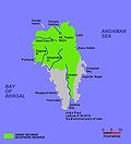
Geography

Great Nicobar is located 180 km (110 mi) to the north of the island of Sumatra. The island covers 921 km2 (356 sq mi) but is sparsely inhabited, with a population of 8067. It is largely covered by rainforest and known for its diverse wildlife.

Topography

The island has several rivers, including the Alexandra, Amrit Kaur, Dogmar and Galathea. Virtually all rivers flow in a southern or southwesterly direction, which is indicative of the general slope of the terrain across the island. There are undulating hills throughout the island, with the main range running in a north–south orientation. Mount Thullier, which is part of this range, has the highest elevation of any point in the Nicobars, at 642 m above sea level. [5]

Indira Point (6°45’10″N and 93°49’36″E) is the southernmost point of the Great Nicobar Island and India itself. Indira Point subsided 4.25 m in the 26 December 2004 tsunami and the lighthouse there was damaged. The lighthouse was subsequently made functional.

Ecology

The island is part of the Nicobar Islands rain forests ecoregion. Plant communities include mangroves and coastal forests near the seashore, and evergreen and deciduous forests in the interior. [6]

The majority of the island is designated as the Great Nicobar Biosphere Reserve— home to many unique and endemic species of plants and animals including the Nicobar scrubfowl (Megapodius nicobariensis, a megapode bird), the edible-nest swiftlet (Aerodramus fuciphagus), the Nicobar long-tailed macaque (Macaca fascicularis umbrosa), saltwater crocodile (Crocodylus porosus), giant leatherback sea turtle (Dermochelys coriacea), Malayan box turtle, Nicobar tree shrew, reticulated python (Python reticulatus) and the giant robber crab (or coconut crab, Birgus latro).

Demography

The island is home to the Shompen people. [7]

Transportation

There is a 915m airstrip at Campbell Bay/Tenlaa on the East coast. [8] [9]

The INS Baaz naval air station, near Campbell Bay, is under the joint-services Andaman and Nicobar Command (ANC) of the Indian Armed Forces. [10] It is the southernmost air station of the Indian Armed Forces. [11]

Great Nicobar Development Plan

The Great Nicobar Development Plan is a massive infrastructure plan (including a major transshipment port, airport, and future strategic defense) for the southern tip of Great Nicobar Island, India. The plan has generated criticism over the consequences of deforestation and giant leatherback sea turtle nesting sites. The plan was proposed on January 18, 2021 by an Indian policy think tank (NITI Aayog) and informed by a feasibility report written by AECOM India Private Limited. Environmental Justice groups have pushed back claiming that the development plan would make it unlikely that the leatherback sea turtles would continue to nest in the Galathea Bay and negatively impact the nomadic livelihoods of the indigenous Shompen people. The NITI Aayog plan envisages 650,000 people inhabiting the island by 2050. Its current population is only around 8,500. In fact, the total population of the archipelago, composed of over 500 islands of which only around 40 are inhabited, is around 380,000. The population increase is expected to impose a significant ecological pressure on the island and its surroundings. [12] [13]

Indira Point

Indira Point is the name of the southernmost point of Republic of India. It is situated on Great Nicobar Island in the Nicobar Islands, which are located in the eastern Indian Ocean at 6°45’10″N and 93°49’36″E. This is not on the Indian mainland, but within the Union Territory of Andaman and Nicobar Islands. The name of the point was changed from Pygmalion Point on 18 October 1985 [14] in commemoration of Indira Gandhi. It was formerly known by various names that include Pygmalion Point, Parsons Point, and for a brief period India Point. [15]

It is located 540 km and more than a day's sea voyage from Port Blair, [16] the capital city and main port of the Andaman and Nicobar Islands. It is approximately 163 km by sea from Sumatra, Indonesia. [15] Rondo Island, Indonesia's northernmost island in Sabang district of Aceh province of Sumatra, lies south of Indira point. [17] India and Indonesia are planning to collaborate to construct a port at Sabang to protect the channel between Great Nicobar Island and Rondo Island (c. May 2019). [18]

Indira Point lighthouse

Indira Point has a 35 m high cast iron (with red and white bands) lighthouse with 16 nautical miles range. The lighthouse has (RACON (Code 'G') ii DGPS station) with a 300 mm 4 panel revolving light inside a 2.5 m diameter lantern house (BBT). It is an important landmark on the international shipping lane Colombo-Singapore route via Malacca Strait that passes south of Indira Point. It also has a helipad. [19]

2004 tsunami

The tsunami which resulted from the Indian Ocean earthquake of 2004 inundated much of the area. This partly damaged the lighthouse, which subsided 4.25 m. [20] As a result of this subsidence, the coast retreated and the sea moved permanently inland. The lighthouse has since been repaired. [21]

The base of the lighthouse was 5 m above sea level when constructed in 1972. After the tsunami, the sea floor fell and the base was less than 1 m above sea level. Since then, the subsidence has decreased somewhat as the ocean floor slowly rebounds, and the lighthouse base become more elevated. Indira point was mostly submerged.

See also

Related Research Articles

<span class="mw-page-title-main">Andaman and Nicobar Islands</span> Union territory of India

The Andaman and Nicobar Islands is a union territory of India. It consists of 836 islands grouped into two island groups, the northern Andaman Islands and the southern Nicobar Islands, separated by a 150 km (93 mi) wide channel of which only 31 are inhabited. Port Blair is the capital and largest city of the territory, located about 1,190 km (740 mi) from Chennai and 1,255 km (780 mi) from Kolkata in mainland India. The islands are sandwiched between the Bay of Bengal to the west and the Andaman Sea to the east with the northern-most point located 901 km (560 mi) from the mouth of Hooghly river. Indira Point at 6°45’10″N and 93°49’36″E at the southern tip of Great Nicobar is the southernmost point of India.

<span class="mw-page-title-main">Andaman Sea</span> Marginal sea of the northeastern Indian Ocean

The Andaman Sea is a marginal sea of the northeastern Indian Ocean bounded by the coastlines of Myanmar and Thailand along the Gulf of Martaban and the west side of the Malay Peninsula, and separated from the Bay of Bengal to its west by the Andaman Islands and the Nicobar Islands. Its southern end is at Breueh Island just north of Sumatra, with the Strait of Malacca further southeast.

<span class="mw-page-title-main">Nicobar Islands</span> Island group in the Indian Ocean

The Nicobar Islands are an archipelagic island chain in the eastern Indian Ocean. They are located in Southeast Asia, 150 kilometres (93 mi) northwest of Aceh on Sumatra, and separated from Thailand to the east by the Andaman Sea. Located 1,300 kilometres (810 mi) southeast of the Indian subcontinent, across the Bay of Bengal, they are part of India, as the Nicobar district within the union territory of the Andaman and Nicobar Islands.

<span class="mw-page-title-main">Effect of the 2004 Indian Ocean earthquake on India</span> Effect of 2004

According to official estimates in India, 10,749 people were killed, 5,640 people were missing and thousands of people became homeless when a tsunami triggered by the 2004 Indian Ocean earthquake near the Indonesian island of Sumatra struck the southern coast on 26 December 2004. The earthquake registered 9.1–9.3 Mw and was the largest in five decades. It was followed by strong aftershocks on the Andaman and Nicobar Islands. The death toll of the earthquake was 1,500 people.

<span class="mw-page-title-main">Great Nicobar Biosphere Reserve</span>

The Great Nicobar Biosphere Reserve encompasses a large part of the island of Great Nicobar, the largest of the Nicobar Islands in the Indian Union Territory of Andaman and Nicobar Islands. The Nicobars lie in the Bay of Bengal, eastern Indian Ocean, 190 km (120 mi) to the north of the Indonesian island of Sumatra. The reserve has a total core area of approximately 885 km2, surrounded by a 12 km-wide "forest buffer zone". In year 2013 it was included in the list of Man and Biosphere program of UNESCO to promote sustainable development based on local community effort and sound science.

Indira Point, the southernmost point of India's territory, is a village in the Nicobar district at Great Nicobar Island of Andaman and Nicobar Islands in India. It is located in the Great Nicobar tehsil.

Nicobar district is one of three districts in the Indian union territory of the Andaman and Nicobar Islands. The district's administrative territory encompasses all of the Nicobar Islands, which are located in the Indian Ocean, between the Bay of Bengal and the Andaman Sea. The headquarters of the district is the village of Malacca, located on the island of Car Nicobar.

<span class="mw-page-title-main">Narcondam Island</span> Island in India

Narcondam, India's easternmost island, is a small volcanic island located in the northern Andaman Sea. The island's peak rises to 710 m above mean sea level, and it is formed of andesite. It is part of the Andaman Islands, the main body of which lie approximately 74 km (46 mi) to the west.The island is part of the Indian union territory of Andaman and Nicobar Islands. The island is small, covering an area of approximately 7.6 square kilometres. It was classified as a dormant volcano by the Geological Survey of India.

The Coco Islands are a small group of islands in the northeastern Bay of Bengal. They are part of the Yangon Region of Myanmar since 1937. The islands are located 414 km (257 mi) south of the city of Yangon. Coco Island group consists of five islands: four on the Great Coco Reef and one on the Little Coco Reef. To the north of this island group lies Preparis Island, belonging to Myanmar. To the south lies the Landfall Island, belonging to India.

The Andaman and Nicobar Command (ANC) is a integrated tri-services command of the Indian Armed Forces, based at Port Blair in the Andaman and Nicobar Islands, a Union Territory of India. It was created in 2001 to safeguard India's strategic interests in Southeast Asia and the Strait of Malacca by increasing rapid deployment of military assets in the region. It provides logistical and administrative support to naval ships which are sent on deployment to East Asia and the Pacific Ocean.

<span class="mw-page-title-main">Campbell Bay, Great Nicobar</span> Village in Andaman and Nicobar Islands, India

Campbell Bay is a village in the Nicobar district of Andaman and Nicobar Islands, India. It is located in the Great Nicobar tehsil. The island's Indira Point is famous for being the southernmost point of India.

North Cinque Island or Gue-a-lue is an uninhabited island of the Andaman Islands. It belongs to the South Andaman administrative district, part of the Indian union territory of Andaman and Nicobar Islands. The island is 37 km (23 mi) south of Port Blair.

<span class="mw-page-title-main">INS Baaz</span> Airport in Andaman & Nicobar Islands, India

INS Baaz is an Indian naval air station under the joint-services Andaman and Nicobar Command (ANC) of the Indian Armed Forces. It is located near Campbell Bay, on Great Nicobar island in the Andaman & Nicobar Islands. It is the southernmost air station of the Indian Armed Forces. It overlooks the Strait of Malacca as well as the Six Degree channel between Great Nicobar and the Indonesian island of Sumatra.

Rondo Island is Indonesia's northernmost territory, located in the Andaman Sea, with a 0.650 km2 area 35m above sea level. The island is one of the outlying islands of Indonesia in the Aceh province of the Sumatra region. It is administratively part of Ujung Bau village in the Sukakarya district of Sabang city, whose administration center is on Weh Island, south of Rondo. Rondo is 50 km offshore from Indonesia's Sumatra mainland. This otherwise uninhabited island, accessible only by boat, has an Indonesian military outpost with a heliport and blue-roofed barracks, an adjacent lighthouse complex with a red-roofed lighthouse keeper's house and a white skeletal lighthouse topped with a viewing gallery and lantern.

Landfall Island is the northernmost island of the Indian union territory of Andaman and Nicobar Islands. It belongs to the territory's North and Middle Andaman administrative district. The island lies 220 km (137 mi) north of Port Blair, and is situated 300 km (186 mi) south of Myanmar. It is home to the Kari tribe.

<span class="mw-page-title-main">NITI Aayog</span> Indian government think tank

The NITI Aayog serves as the apex public policy think tank of the Government of India, and the nodal agency tasked with catalyzing economic development, and fostering cooperative federalism and moving away from bargaining federalism through the involvement of State Governments of India in the economic policy-making process using a bottom-up approach. Its initiatives include "15-year road map", "7-year vision, strategy, and action plan", AMRUT, Digital India, Atal Innovation Mission, Medical Education Reform, agriculture reforms, Indices Measuring States’ Performance in Health, Education and Water Management, Sub-Group of Chief Ministers on Rationalization of Centrally Sponsored Schemes, Sub-Group of Chief Ministers on Swachh Bharat Abhiyan, Sub-Group of Chief Ministers on Skill Development, Task Forces on Agriculture and up of Poverty, and Transforming India Lecture Series.

Shompen hut is a village in the Nicobar district of Andaman and Nicobar Islands, India. It is located in the Great Nicobar tehsil.

Laxmi Nagar is a village in the Nicobar district of Andaman and Nicobar Islands, India. It is located in the Great Nicobar tehsil. It is the location of India's southernmost land tip, Indira Point.

The Andaman and Nicobar Islands is an archipelago of 572 islands of which 37 are inhabited. It is a union territory of India.

Great Nicobar Development Plan is a planned mega-infrastructure project for the southern tip of Great Nicobar Island in Andaman Sea of India. The island comes under the Nicobar district administriation in the Indian union territory of Andaman and Nicobar Islands.

References

  1. "Islandwise Area and Population – 2011 Census" (PDF). Government of Andaman.
  2. Registration Plate Numbers added to ISO Code
  3. "Nicobar Islands | islands, India | Britannica". www.britannica.com. Retrieved 24 January 2023.
  4. "Wu Bei Zhi Map 17". Library of Congress.
  5. Shyam Singh Shashi (2005), Encyclopaedia of Indian Tribes, Anmol Publications Pvt Ltd, ISBN   81-7041-836-4, ... The main hill range runs from the north to south. Average height of the hills is 300m to 400m. The highest peak is Mount Thullier ...
  6. "Nicobar Islands rain forests". Terrestrial Ecoregions. World Wildlife Fund.
  7. Trivedi, Rajni; Sitalaximi, T.; Banerjee, Jheelam; Singh, Anamika; Sircar, P. K.; Kashyap, V. K. (March 2006). "Molecular insights into the origins of the Shompen, a declining population of the Nicobar archipelago". Journal of Human Genetics. 51 (3): 217–226. doi: 10.1007/s10038-005-0349-2 . PMID   16453062.
  8. "Missing Malaysia Airlines MH370 'Deliberately Diverted' Towards Andaman and Nicobar Islands: List of Unused Airports Where the Plane Possibly Landed [Photos]". International Business Times .
  9. "Runways – Campbell Bay Airport Campbell Bay, Andaman and Nicobar Islands, India".
  10. "Naval air station opened in Campbell Bay". The Hindu. 31 July 2012.
  11. "INS Baaz to keep hawk eye on threats in Indian Ocean Region". The Times of India . 1 August 2012. Archived from the original on 26 January 2013.
  12. NITI Aayog's Vision for Great Nicobar Is at Great Odds With Islanders' Reality, Rishika Pardika, Science, The Wire, 29/05/2021
  13. EJOLT. "Great Nicobar development plan, Nicobar islands, India | EJAtlas". Environmental Justice Atlas . Retrieved 19 April 2022.
  14. "Memories of Andaman and Nicobar Island on 18th October". Archived from the original on 2 February 2014. Retrieved 29 January 2014.
  15. 1 2 Gupta, K.R.; Gupta, Amita (2006). Concise Encyclopaedia of India. p. 1209. ISBN   81-269-0640-5.
  16. Sharma, A.N. (2003). Tribal Development in Andaman Islands. p. 6. ISBN   81-7625-347-2.
  17. "Rondo Island, The Rich Uninhabited Island". Archived from the original on 3 November 2012. Retrieved 19 May 2018.
  18. India seeks to aid Indonesia in developing port in Aceh, Economic Times, 19 May 2018.
  19. "Welcome to INDIRA POINT LIGHT HOUSE". Directorate General of Lighthouses and Lightships. Archived from the original on 3 March 2013. Retrieved 26 December 2012.
  20. Bilham, Roger. "Indira Point Lighthouse Subsidence 2004–2005".
  21. "Defunct Indira Point Lighthouse RACON repaired". oneindia.in. Retrieved 26 December 2012.