
The Gulf of Papua is located in the southern coast region of New Guinea. It has a total surface area of 70,400 km2 (27,200 sq mi).

Gulf Province is a province of Papua New Guinea located on the southern coast. The provincial capital is Kerema. The 34,472 km2 province is dominated by mountains, lowland river deltas, and grassland flood plains. In Gulf Province, the Kikori, Turama, Purari, and Vailala rivers meet the Papuan Gulf. The province has the second-smallest population of all the provinces of Papua New Guinea with 106,898 inhabitants. The province shares land borders with Western Province to the west, Southern Highlands, Chimbu, and Eastern Highlands to the north, Morobe Province to the east, and Central Province to the southeast.

The Purari is a river that originates in the south central highlands especially in Kandep District of Enga Province of Papua New Guinea, flowing 630 kilometres (391 mi) though Gulf Province to the Gulf of Papua. The Purari has a 33,670 km2 (13,000 sq mi) drainage basin and is the third largest river in Papua New Guinea. The discharge varies through the year, averaging around 3,000 m3/s (110,000 cu ft/s)–4,000 m3/s (140,000 cu ft/s) at the delta.

The Kikori River is a major river in southern Papua New Guinea on the island of New Guinea. The river has a total length of 445 km (277 mi) and flows southeast into the Gulf of Papua, with its delta at the head of the gulf. The settlement of Kikori lies on the delta.

Mount Bosavi is a mountain in the Southern Highlands province, Papua New Guinea. It is the collapsed cone of an extinct volcano on the Great Papuan Plateau, part of the Kikori River basin. The crater is approximately 4 km wide and 1 km deep; it is home to a number of endemic species.

Lake Kutubu is the second-largest lake in Papua New Guinea, after Lake Murray, and, at 800 m above sea level, the largest upland body of water, with an area of 49.24 km², and a total catchment area of 250 km². Lake Kutubu and Lake Sentani form an ecoregion on the WWF's Global 200. Kutubu lies in the Southern Highlands Province of Papua New Guinea, east of the Kikori River into which it drains, and about 50 km southwest of Mendi, the provincial capital. It is one of the few lakes in the country that occurs in a depression in the rugged interior mountains. The lake has a few islands, the largest of which is Wasemi in its northern part. The water of Lake Kutubu, fed by several streams originating mostly from underground sources, is clear and reaches a depth of 70 m (230 feet). The catchment is inhabited by two main ethnic groups, the Foe to the south and the Fasu to the north. Thirty-three villages lie in the catchment area, with a total estimated population of 10,885.

Jack Gordon Hides was an explorer of the then-Australian-controlled territories of Papua and New Guinea, now modern Papua New Guinea. He served as a Patrol Officer from 1931 to 1936, and led several expeditions in the early 1930s.

Papua New Guinea, a sovereign state in Oceania, is the most linguistically diverse country in the world. According to Ethnologue, there are 840 living languages spoken in the country. In 2006, Papua New Guinea Prime Minister Sir Michael Somare stated that "Papua New Guinea has 832 living languages ."

The Bosavi or Papuan Plateau languages belong to the Trans-New Guinea language family according to the classifications made by Malcolm Ross and Timothy Usher. This language family derives its name from Mount Bosavi and the Papuan Plateau.

The East Strickland or Strickland River languages are a family of Papuan languages.
The Etoro, or Edolo, are a tribe and ethnic group of Papua New Guinea. Their territory comprises the southern slopes of Mt. Sisa, along the southern edge of the central mountain range of New Guinea, near the Papuan Plateau. They are well known among anthropologists because of ritual acts practiced between the young boys and men of the tribe. The Etoro believe that young males must ingest the semen of their elders to achieve adult male status and to properly mature and grow strong.
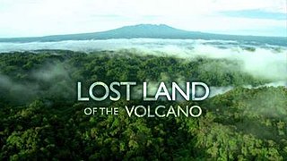
Lost Land of the Volcano is a three-part nature documentary series produced by the BBC Natural History Unit which follows a scientific expedition to the island of New Guinea. The expedition team, which includes specialist zoologists, explorers and the BBC crew, travels to the extinct volcano of Mount Bosavi in central Papua New Guinea to document the biodiversity of this little-visited area and search for new species. At the time of filming, logging was taking place about 20 miles (32 km) south from the volcano, and one of expedition's aims was to find evidence to support the case to protect the area. Some members of the expedition team travelled to the island of New Britain several hundred kilometres to the east to chart an unexplored cave system and observe an active volcano.

The Kaluli are a clan of indigenous peoples who live in the rain forests of the Great Papuan Plateau in Papua New Guinea. The Kaluli, who numbered approximately 2,000 people in 1987, are the most numerous and well documented by post-contact ethnographers and missionaries among the four language-clans of Bosavi kalu that speak non-Austronesian languages. Their numbers are thought to have declined precipitously following post-contact disease epidemics in the 1940s, and have not rebounded due to high infant mortality rates and periodic influenza outbreaks. The Kaluli are mostly monolingual in an ergative language.
Kaluli is a language spoken in Papua New Guinea. It is a developing language with 3,100 speakers. Some people refer to this language as Bosavi, however the people themselves refer to the language as Kaluli. There are four dialects, Ologo, Kaluli, Walulu, and Kugenesi. The differences between the dialects are not clear. Their writing system uses the Latin script. Kaluli belongs to the Trans-New Guinea language family. Kaluli was first analyzed by Murray Rule in 1964 who wrote a preliminary phonological and morphological analysis. A dictionary of Kaluli has been compiled by Schieffelin and Feld (1998).

Pawaia, also known as Sira, Tudahwe, Yasa, is a Papuan language that forms a tentative independent branch of the Trans–New Guinea family in the classification of Malcolm Ross (2005).
Pilikambi Rural LLG is one of the four Local-Level Government Areas (LLGs) of Lagaip Porgera Electorate in Enga Province, Papua New Guinea. The other three LLGs in the district are Maip-Mulitaka Rural, Paiela-Hewa Rural and Porgera.

Charles Henry Karius was an Australian Assistant Resident Magistrate (Kiap) in Australian administered Papua who traversed the widest part of the island from the Fly River in Papua to the source of the Sepik River in New Guinea from December 1926 to January 1928.
The Lamari River is a river that originates in the Kratke Range in the south central highlands of Eastern Highlands Province of Papua New Guinea. It flows into the Purari River basin.

