Related Research Articles

The Peak Cavern, also known as the Devil's Arse, is one of the four show caves in Castleton, Derbyshire, England. Peakshole Water flows through and out of the cave, which has the largest cave entrance in Britain.
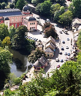
The Heights of Abraham is a tourist attraction in Matlock Bath, Derbyshire, England. It consists of a hilltop park on top of Masson Hill, accessed from the village by either the Heights of Abraham cable car or a steep zig-zag path. The heights are named after a supposed resemblance to the Plains of Abraham, also known as the Heights of Abraham, in Quebec, Canada, where James Wolfe died in battle.

Treak Cliff Cavern is a show cave near Castleton in Derbyshire, England. It is part of the Castleton Site of Special Scientific Interest and one of only two sites where the ornamental mineral Blue John is still excavated. As part of an agreement with English Nature, the Blue John that can be seen in the show cave is not mined but it is extracted in small quantities from other areas of the cave and made into saleable items like bowls, jewellery and ornaments.

California Cavern is a Limestone cave in the Sierra Nevada foothills, in Cave City, Calaveras County, California.

Thor's Cave is a natural cavern located at SK09865496 in the Manifold Valley of the White Peak in Staffordshire, England. It is classified as a karst cave. Located in a steep limestone crag, the cave entrance, a symmetrical arch 7.5 metres wide and 10 metres high, is prominently visible from the valley bottom, around 80 metres (260 feet) below. Reached by an easy stepped path from the Manifold Way, the cave is a popular tourist spot, with views over the Manifold Valley. The second entrance is known as the "West Window", below which is a second cave, Thor's Fissure Cavern.
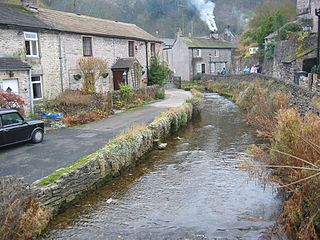
Peakshole Water is a stream in the Derbyshire Peak District named after its source, Peak Cavern. It flows through the village of Castleton to join the River Noe in nearby Hope. Despite its name, much of its flow actually emerges from the Russet Well, a resurgence in a garden on the east side of the gorge below the main Peak Cavern entrance, described as the "main resurgence of the Castleton area", which drains a series of swallets on the other side of the Pennine watershed below Rushup Edge. The resurgence has been explored by cave divers to a depth of 82 feet (25 m) but further exploration was halted by a constriction.

Llechwedd is a visitor attraction near Blaenau Ffestiniog, Gwynedd, Wales. It details the history of slate quarrying in the town and specifically the Llechwedd quarry in which it is located. The main aspect of Llechwedd is its Llechwedd Deep Mine Tour which has the steepest narrow gauge railway in the UK and travels over 500 feet underground to the disused slate caverns, and the Quarry Explorer Tour which heads out to the furthest reaches of the Llechwedd site to explore the history of mining in the area.

Moaning Caverns is a solutional cave located in the Calaveras County, California, near Vallecito, California in the heart of the state's Gold Country. It is developed in marble of the Calaveras Formation. It was discovered in modern times by gold miners in 1851, but it has long been known as an interesting geological feature by prehistoric peoples. It gets its name from the moaning sound that echoed out of the cave luring people to the entrance, however expansion of the opening to allow access for the public disrupted the sounds. The portion of the cave developed for tourists consists of a spacious vertical shaft 165 feet tall, which is descended by a combination of stairs and a unique 100-foot-high (30 m) spiral staircase built in the early 1900s. It is open to the public for walking tours and spelunking. Including the off-trail areas, the cave reaches a depth of 410 feet.

Poole's Cavern or Poole's Hole is a two-million-year-old natural limestone cave on the edge of Buxton in the Peak District, in the county of Derbyshire, England.
Titan is a natural cavern near Castleton in the Derbyshire Peak District, and is the deepest shaft of any known cave in Britain, at 141.5 metres (464 ft). The existence of Titan was revealed in November 2006, following its discovery on 1 January 1999 after cavers discovered connections from the James Hall Over Engine Mine to both Speedwell Cavern and Peak Cavern. Previously, the deepest known underground shaft in Britain had been Gaping Gill on the slopes of Ingleborough in the Yorkshire Dales.
Oxlow Cavern is a part-natural and part-mined cavern near Castleton in Derbyshire, England. It is situated on the south side of the road running from the A623 at Sparrowpit to the Winnats Pass, west of Castleton, and is almost opposite Giant's Hole on the other side of the road. A few yards from Oxlow Cavern is the connecting Maskill Mine.

Odin Mine is a disused lead mine in the Peak District National Park, situated at grid reference SK133835. It lies on a site of 25 hectares near the village of Castleton, England. It is the oldest documented mine in Derbyshire and is thought to be one of the oldest lead mines in England. The mine is a Scheduled Ancient Monument and has biological and geological significance within the Castleton Site of Special Scientific Interest.

Onondaga Cave State Park is a Missouri state park located on the Meramec River approximately 5 miles (8.0 km) southeast of the village of Leasburg. The park was established in 1982. Park activities include cave tours, camping, fishing, hiking, picnicking, and swimming.
The Milwr Tunnel is a mine drainage adit running some 10 miles from the hamlet of Cadole near Loggerheads, Denbighshire to Bagillt on the Dee Estuary in North Wales. It was originally built to drain the lead mines beneath Halkyn Mountain, which were plagued with flooding in their lower levels, but enabled the exploitation of new lodes and was variously used for the extraction of lead, zinc and limestone during its working history. It is part of a network of mines, lodes and natural cave systems – the Halkyn United Mines – that extends for up to 100 kilometres, the longest in the United Kingdom.
Great Masson Cavern is one of two caves at the Heights of Abraham, Matlock Bath, Derbyshire, England. The other is Great Rutland Cavern.

Crank Caverns is the common name of the remains of the Rainford Delph Quarry near Crank in St. Helens, Merseyside, England. It is a network of tunnels and caverns, as well as an extensive woodland. Information in the St. Helens local history archives states that sandstone quarrying began here as early as 1730. As the quarry expanded, the cost of purchasing land to open cast mine it increased, so it was decided to opt for a different method. Instead of quarrying out the stone, they would mine it out, following a seam of stone until it ran out. This resulted in the network of caves, tunnels and shafts we see today. Rainford Delph is listed as a Colliery by 1854, under the ownership of Charles Howarth or Yorkshire Charlie as he was known locally by 1880. Mining finally ceased and the woods and caverns were used as a game reserve by the Earl of Derby until 1939, when they became a storage facility for ammunition for the anti-aircraft position at Crank. After the war, the caverns ceased use as a game reserve. Today, Crank Caverns are not officially open to the publicand due to their increasing instability, attempts have been made to close access to the caverns and tunnels themselves. Despite this, the site is still physically accessible from a nearby public footpath and is still a draw for generations of curious locals who wish to explore, many having heard the numerous local myths and legends from an early age.
Shute Shelve Cavern is a natural cave system located in Shute Shelve Hill, Somerset, England, above Axbridge in the Mendip Hills not far from Cheddar.
References
- ↑ Oldham, Tony and Anne (1972). Discovering Caves: a guide to the Show Caves of Britain. Shire Publications. ISBN 0852631553.
Coordinates: 53°07′28″N1°33′54″W / 53.12444°N 1.56500°W
| | This Derbyshire location article is a stub. You can help Wikipedia by expanding it. |