Greater Binghamton Airport

Last updated

Greater Binghamton Airport

Edwin A. Link Field
BGM Airport Logo.png
Greater Binghamton Airport - New York.jpg
Summary
Airport typePublic
Owner Broome County United States
Serves Binghamton, New York, United States
Location2534 Airport Rd., Johnson City, New York, United States
Elevation  AMSL 1,636 ft / 499 m
Coordinates 42°12′31″N075°58′47″W / 42.20861°N 75.97972°W / 42.20861; -75.97972
Website www.FlyBGM.com
Maps
KBGM Airport Diagram.PDF
FAA airport diagram (2013)
Greater Binghamton Airport
Runways
Direction LengthSurface
ftm
16/347,3052,227Asphalt
10/285,0011,524Asphalt
Statistics (2021)
Aircraft operations (year ending 1/31/2021)13,323
Based aircraft (2021)39

Greater Binghamton Airport( IATA : BGM, ICAO : KBGM, FAA LID : BGM) is a county-owned American airport eight miles north of Binghamton, in Broome County, New York. [1] It is in East Maine, New York and serves the Southern Tier of New York.

Contents

The airport was named Broome County Airport through the 1970s. It was renamed Edwin A. Link Field-Broome County Airport to honor the inventor of the aircraft instrument simulator, the Link Trainer, a name it kept until the 1990s when it was again renamed as Binghamton Regional Airport. The name Greater Binghamton Airport was chosen in 2003. The field is still named in Link's honor.

The National Plan of Integrated Airport Systems for 2011–2015 categorized it as a primary commercial service airport (more than 10,000 enplanements per year). [2] Federal Aviation Administration records say the airport had 108,325 passenger boardings (enplanements) in calendar year 2008, [3] 98,090 in 2009 and 108,988 in 2010. [4]

History

The Greater Binghamton Airport (BGM) (originally Broome County Airport) has served Binghamton for six decades. Development started in 1945, due to difficult night operations at the Tri-Cities Airport in Endicott, New York during World War II. Broome County Airport opened in 1951 with a 5,600-foot main Runway 16/34, and a 5,002-foot crosswind Runway 10/28.

An approach lighting system was added in 1959 to the runway 34 approach end. The main runway was extended 700 feet in 1969. In the early 1980s the field was renamed Edwin A. Link Field-Broome County Airport in honor of Edwin A. Link a well-known inventor and aviation pioneer in the Binghamton area. Mr. Link was known for the creation of the Link Trainer, the first trainer that taught pilots how to fly in instrument meteorological conditions using only the instruments in the cockpit ("Facility Orientation Guide", n.d.).

In the 1950s Mohawk, Trans World Airlines, and Colonial Airlines (later Eastern Air Lines) stopped at BGM; TWA left in 1965 and Eastern left in 1969-70. Mohawk's successors' jets still stopped into the 1990s. In the 1980s a commuter airline, Brockway Air, flew Beechcraft 1900s and Fokker F-27s from Broome County airport to Syracuse, Boston, Albany, Keene, NH, Worcester, Burlington, and Rutland.

The south, southeast-facing runway 16 gained an instrument landing system during the 1970s along with a medium intensity approach lighting system with runway alignment indicator lights to lower landing minimums, but the localizer antenna was placed to the east of the runway with an offset. The airport began extending the north end of the main runway 16/34 in 1988; the extension from 6,298 to 7,500 feet was completed in October 1990. In 1991 the airport was renamed to Binghamton Regional Airport. In 2002 Runway 16/34 was shortened to 7,100 feet to make room for an Engineered Material Arresting System (EMAS). The EMAS is a bed of material that will crush under the weight of an aircraft, stopping the aircraft in the event of a runway overrun.

In 2003 the airport was again renamed to the Greater Binghamton Airport. The airport's old linear terminal was unable to keep up with regional jet traffic, and four new jet bridges opened in July 2004. BGM got a $12.3 million federal grant in September 2011 to replace the old EMAS system installed in 2002 and extend Runway 16/34 to 7,304 feet. The project was completed in November 2012 and led to a displaced threshold on Runway 34.

The airport lost significant airline service in the 2010s, with United Airlines and American Airlines exiting the airport in 2016, leaving the airport with one carrier, a single Delta Air Lines route to Detroit, for several years. [5]

In August 2022, low cost carrier Avelo Airlines announced new service from Binghamton to Fort Myers and Orlando in Florida. These flights will be operated by a Boeing 737-800 aircraft. This is the first service to Florida the airport has had. [6] The airline canceled the launch of its Fort Myers focus city on October 13, citing a lack of bookings due to Hurricane Ian. [7]

On September 14, 2022, New York Governor Kathy Hochul announced that the Greater Binghamton Airport was being awarded funds for renovations under the state's Upstate Airport Economic Development and Revitalization initiative. US$32 million of state funds and $5M from other sources was earmarked for upgrades including integration of the general aviation and passenger terminals, replacement of the loading-zone canopy, and construction of new facilities for U.S. Customs and Border Protection. [8]

Facilities

The airport covers 1,199 acres (485 ha) at an elevation of 1,636 feet (499 m). It has two asphalt runways: 16/34 is 7,305 by 150 feet (2,227 x 46 m) and 10/28 is 5,001 by 150 feet (1,524 x 46 m). [1]

In the year ending January 31, 2021 the airport had 13,323 aircraft operations, average 36 per day: 84% general aviation, 13% air taxi, 3% military, and <1% airline. 39 aircraft were then based at the airport: 25 single-engine, 10 multi-engine, and 4 jet. [1]

As of 2020, the airport has one scheduled departure flight (Delta flight to Detroit) and one scheduled arrival flight (Delta flight from Detroit).

Airlines and destinations

AirlinesDestinations
Avelo Airlines Seasonal: Orlando
Delta Connection Detroit [9]


Top destinations

Busiest domestic routes out of BGM
(January 2023 – December 2023) [10]
RankCityPassengersCarriers
1 New York-LaGuardia, New York 20,480Delta
2 Orlando, Florida 15,900Avelo
3 Detroit, MI 240Delta

Incidents

See also

Related Research Articles

<span class="mw-page-title-main">Pensacola International Airport</span> International airport in Pensacola, Florida, United States

Pensacola International Airport, formerly Pensacola Gulf Coast Regional Airport and Pensacola Regional Airport, and temporarily branded Pensacola Intergalactic Airport each February in recognition of the local Pensacon convention, is a public use airport three nautical miles northeast of the central business district of Pensacola, in Escambia County, Florida, United States. It is owned by the City of Pensacola. Despite its name, the airport does not offer scheduled international flights, though chartered international flights are not uncommon. This airport is one of the five major airports in North Florida, and among these is the second largest by passenger count, only behind Jacksonville. The other airports in the North Florida region are: Northwest Florida Beaches International Airport, Destin-Fort Walton Beach Airport, Tallahassee International Airport, and Jacksonville International Airport.

<span class="mw-page-title-main">Yeager Airport</span> Airport in Kanawha County, West Virginia

West Virginia International Yeager Airport is a public airport 3 miles (4.8 km) east of downtown Charleston, in unincorporated Kanawha County, West Virginia, United States. It is owned by the Central West Virginia Regional Airport Authority. The airport hosts McLaughlin Air National Guard Base, home to eight C-130 Hercules aircraft of the West Virginia Air National Guard's 130th Airlift Wing, an Air Mobility Command (AMC)-gained unit of the West Virginia Air National Guard.

Cortez Municipal Airport is three miles southwest of Cortez, in Montezuma County, Colorado, United States. It has passenger service from one airline: Key Lime Air DBA Denver Air Connection.

<span class="mw-page-title-main">Bert Mooney Airport</span> Airport in Montana, United States

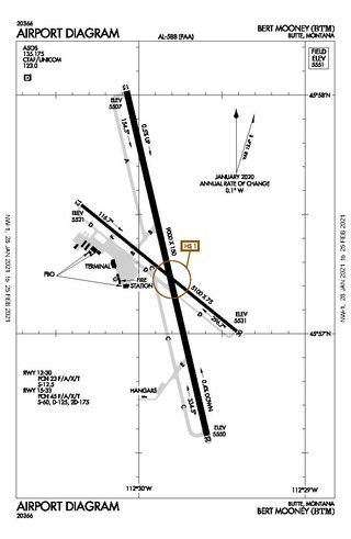
Bert Mooney Airport is a public airport three miles southeast of Butte, in Silver Bow County, Montana, United States. It is owned by the Bert Mooney Airport Authority.

<span class="mw-page-title-main">Presque Isle International Airport</span> Airport

Presque Isle International Airport, formally Northern Maine Regional Airport at Presque Isle, is a mile northwest of Presque Isle, in Aroostook County, Maine, United States. It serves the residents of Presque Isle and a vast area of northern Maine and northwestern New Brunswick. Airline flights to Newark Liberty International Airport are subsidized by the federal government's Essential Air Service program at a cost of $3,892,174.

<span class="mw-page-title-main">DeKalb–Peachtree Airport</span> Airport in the United States

DeKalb–Peachtree Airport is a county-owned, public-use airport in DeKalb County, Georgia, United States. The airport is located in the city of Chamblee, just northeast of Atlanta. It is also known commonly as Peachtree–DeKalb Airport, or simply PDK. Other names include Peachtree Airport, DeKalb Airport, or DeKalb County Airport. ASOS weather reports are produced 24 hours per day as "Chamblee". It has airline service with Ultimate Air Shuttle to Cincinnati and Southern Airways Express to Memphis and Destin.

Chadron Municipal Airport is in Dawes County, Nebraska, United States, five miles west of Chadron. It sees one airline, Southern Airways Express, subsidized by the Essential Air Service program.

<span class="mw-page-title-main">Kirksville Regional Airport</span> Domestic airport serving Kirksville, Missouri, United States

Kirksville Regional Airport is four miles south of Kirksville, Missouri, on the west side of US highway 63. One airline schedules passenger flights, subsidized by the Essential Air Service program.

<span class="mw-page-title-main">Range Regional Airport</span> Airport

Range Regional Airport is a public use airport located four nautical miles southeast of the central business district of Hibbing, in Saint Louis County, Minnesota, United States. It was formerly known as Chisholm-Hibbing Airport or Chisholm-Hibbing Municipal Airport. The airport is mostly used for general aviation but is also served by one commercial and one charter airline. Scheduled passenger service is subsidized by the Essential Air Service program.

Columbus Airport is four miles northeast of Columbus, in Muscogee County, Georgia, United States. Serving Georgia's second largest city, it is Georgia's fourth busiest airport.

<span class="mw-page-title-main">Charlottesville–Albemarle Airport</span> Airport serving Charlottesville, Virginia, USA

Charlottesville–Albemarle Airport is an airport eight miles north of Charlottesville, in Albemarle County, Virginia, United States. It opened in 1955 and serves the Charlottesville/Albemarle region with non-stop flights to five major cities on three airlines' subsidiaries. CHO underwent major construction in summer 2006; an 800-foot runway extension began in summer 2010 and was completed in December 2012.

<span class="mw-page-title-main">Williamsport Regional Airport</span> Commercial airport in Williamsport, Pennsylvania

Williamsport Regional Airport serves Williamsport, Pennsylvania, and the surrounding area with a population of roughly 200,000. The airport processes approximately 40,000 passengers annually and has served north central Pennsylvania since 1929.

<span class="mw-page-title-main">Grant County International Airport</span> Airport in Moses Lake, Washington state

Grant County International Airport is a public use airport in the northwest United States, located six miles (10 km) northwest of the central business district of Moses Lake in Grant County, Washington. Formerly a military facility, the airport is owned by the Port of Moses Lake, and its 13,500-foot (4,110 m) runway is the 17th longest in the U.S.

<span class="mw-page-title-main">Wilmington Airport (Delaware)</span> Public airport in Delaware, United States

Wilmington Airport is an airport located in unincorporated New Castle County, Delaware, near Wilmington, Delaware. Owned by New Castle County and operated under a lease agreement with the Delaware River and Bay Authority, it is five miles (8 km) south of Wilmington and about 30 miles (50 km) from Philadelphia, Pennsylvania. It is included in the Federal Aviation Administration (FAA) National Plan of Integrated Airport Systems for 2017–2021, in which it is categorized as a non-hub primary commercial service facility.

<span class="mw-page-title-main">Kenai Municipal Airport</span> Airport

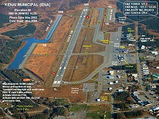
Kenai Municipal Airport is a city-owned, public-use airport located in Kenai, a city in the Kenai Peninsula Borough of the U.S. state of Alaska.

<span class="mw-page-title-main">Unalaska Airport</span> Airport in Amaknak Island

Tom Madsen Airport is a state-owned public-use airport in City of Unalaska, on Amaknak Island in the Aleutian Islands, off the coast of the U.S. state of Alaska. It is located near the Bering Sea coast of Unalaska Island, 800 miles (1,300 km) southwest of Anchorage and 1,950 miles (3,140 km) from Seattle.

<span class="mw-page-title-main">Charlevoix Municipal Airport</span> Airport

Charlevoix Municipal Airport is a city-owned, public-use airport located one nautical mile (2 km) southwest of the central business district of Charlevoix, a city in Charlevoix County, Michigan, United States. It is mostly used for general aviation, but also offers passenger service to Beaver Island via Island Airways and Fresh Air Aviation.

<span class="mw-page-title-main">Skagway Airport</span> Airport

Skagway Airport is a state-owned public-use airport in the city of Skagway, Alaska.

Welke Airport is a privately-owned, public use airport located on Beaver Island in Charlevoix County, Michigan, United States. Scheduled passenger service to Charlevoix Municipal Airport in Charlevoix, Michigan, is provided by Island Airways.

<span class="mw-page-title-main">Pilot Point Airport</span> Airport

Pilot Point Airport is a state-owned, public-use airport located in Pilot Point, a city in the Lake and Peninsula Borough of the U.S. state of Alaska. Scheduled airline service to King Salmon Airport is provided by Grant Aviation.

References

  1. 1 2 3 4 FAA Airport Form 5010 for BGM PDF . Federal Aviation Administration. Effective July 13, 2023.
  2. "2011–2015 NPIAS Report, Appendix A" (PDF). National Plan of Integrated Airport Systems. Federal Aviation Administration. October 4, 2010. Archived from the original (PDF, 2.03 MB) on October 27, 2012.
  3. "Enplanements for CY 2008" (PDF, 1.0 MB). CY 2008 Passenger Boarding and All-Cargo Data. Federal Aviation Administration. December 18, 2009.
  4. "Enplanements for CY 2010" (PDF, 189 KB). CY 2010 Passenger Boarding and All-Cargo Data. Federal Aviation Administration. October 4, 2011.
  5. More passengers flew from Binghamton airport in 2018: What it means for future flights
  6. Flights to Florida coming to Greater Binghamton Airport starting Nov. 16
  7. "Avelo Airlines announces route cancelations to Fort Myers due to impacts of Hurricane Ian | Lansing Airport - LAN".
  8. "Modernization coming to the Greater Binghamton Airport - Pipe Dream". www.bupipedream.com. Retrieved October 24, 2022.
  9. "Detla adds Detroit flights at Greater Binghamton Airport, LaGuardia discontinued". PressConnects. October 21, 2023.
  10. "RITA". BTS | Transtats.
  11. "Crash First Major Accident in 6-Year History of Airport". Binghamton Press. Binghamton. September 5, 1957. p. 22.
  12. "Crash Injures Endicott Pilot". Binghamton Press. Binghamton. July 24, 1955. p. 1.
  13. Handte, Jerry (September 5, 1957). "Co-Pilot Tells How Plane Crashed". Binghamton Press. Binghamton. p. 1.
  14. Ranter, Harro. "ASN Aircraft accident Douglas C-124A Globemaster II 51-5173 Binghamton Airport, NY (BGM)". aviation-safety.net.
  15. "Incident: Colgan SF34 at Binghamton on Nov 24th 2010, engine fire indication".
  16. [ dead link ]