Transportation in Israel is based mainly on private motor vehicles and bus service and an expanding railway network. A lack of inland waterways and the small size of the country make air and water transport of only minor importance in domestic transportation, but they are vitally important for Israel's international transport links. Demands of population growth, political factors, the Israel Defense Forces, tourism and increased traffic set the pace for all sectors, being a major driver in the mobility transition towards railways and public transit while moving away from motorized road transport. All facets of transportation in Israel are under the supervision of the Ministry of Transport and Road Safety.

The Carmelit is an underground funicular railway in Haifa, Israel. Construction started in 1956 and ended in 1959. It is the oldest underground transit system in the Middle East and was the only underground transit system in Israel until the 2023 opening of Tel Aviv Light Rail. The Carmelit has closed down for repair on three occasions.

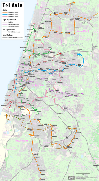
The Tel Aviv Light Rail, Arabic: دانكال تل أبيب للسكك الحديدية الخفيفة, Romanized: Dankal Tall ʾAbīb Lilsīkak Al-hadidiat Al-khāfifa also known as Dankal is a mass transit system for Gush Dan, the Tel Aviv metropolitan area in central Israel. The system will include different modes of mass transit, including rapid transit (metro), light rail transit (LRT), and bus rapid transit (BRT). Overseen by NTA Metropolitan Mass Transit System Ltd., a government agency, the project will complement the intercity and suburban rail network operated by Israel Railways.

Highway 1 is the main highway in Israel, connecting Tel Aviv and Jerusalem, and continuing eastwards to the Jordan Valley in the West Bank.

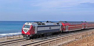
Rail transport in Israel includes heavy rail as well as light rail. Excluding light rail, the network consists of 1,511 kilometers (939 mi) of track, and is undergoing constant expansion. All of the lines are standard gauge and as of 2023 approximately one-fifth of the heavy rail network is electrified, with additional electrification work underway. A government owned rail company, Israel Railways, manages the entire heavy rail network. Most of the network is located on the densely populated coastal plain.

The Tel Aviv transportation system is seen as the hub of the Israeli transport network in terms of road, rail, and air transport. The Israeli road network partly centers on Tel Aviv, with some of the country's largest highways passing through or running to the city. The city forms a major part of the country's rail network, whilst Ben Gurion International Airport located near the city is the country's largest airport. There is also a strong public transport system within the city, based primarily on bus transportation.

The Tel Aviv–Jerusalem railway is a railway line in Israel connecting the cities of Tel Aviv and Jerusalem. The line serves as the main rail link between the two cities, complementing the old Jaffa–Jerusalem railway. As such, the railway is often referred to in Israel as the high-speed railway to Jerusalem to distinguish it from the older, longer and slower line. In spite of that name, the line is not high-speed under the definition used by the International Union of Railways: both its design speed of 200 km/h (125 mph) and its current operational speed of 160 km/h (99 mph) are below the 250 km/h (155 mph) threshold used by the UIC to define high-speed railways, and it is traversed by IR's regular rolling stock instead of the UIC requirement for specially-designed high-speed trains.

The Red Line is the first section of a light rail system in the Tel Aviv metropolitan area, known as the Tel Aviv Light Rail. The line runs from Bat Yam in the south to Petah Tikva in the northeast with a significant portion of it underground. The total cost of the red line is estimated at NIS 11 billion or, approximately US$3 billion. Construction began in 2011, with the testing phase of the line beginning only a decade later, in 2021. After numerous delays concerning the security and safety of the line, it eventually opened on August 18, 2023 with a 100,000+ daily ridership over just 8 hours of operation.

Route 412 is a regional road in the south-east of the Tel Aviv Metropolitan Area in Israel. The road connects Bilu Junction south of Rehovot, with Yehud Ma'arav Junction, running through Rehovot, Ness Ziona, Rishon LeZion and Beit Dagan and spanning a distance of approximately 22 km.

The Coastal railway line is a mainline railway in Israel, which begins just south of the Lebanon-Israel border on the Mediterranean coast, near the town of Nahariya in Northern Israel and stretches almost the entire Mediterranean coast of the country, to just north of the border with the Gaza Strip in the south.
Transport in Bnei Brak occupies a central location within the Gush Dan. It has an important role in transport throughout the region.

Kokhav HaTzafon is a residential neighborhood in northwestern Tel Aviv, Israel.

The Rishon LeZion Moshe Dayan railway station is an Israel Railways station in Rishon LeZion. The station is located adjacent to the Moshe Dayan Interchange on the Ayalon Highway. It serves as the terminus of a new suburban passenger line serving the cities of Holon, Bat Yam, and Rishon LeZion in southern Gush Dan. Current travel time from the station to Tel Aviv HaHagana railway station is about 18 minutes.
The High-speed railway to Eilat (Med-Red) is a proposed Israeli railway that will enable the connection of the main Israeli population centers and Mediterranean ports to the southern city of Eilat on the Red Sea coast, as well as serve commercial freight between the Mediterranean Sea and Red Sea (Eilat). The railway will spur southward from the existing rail line at Beersheba, and continue through Dimona to the Arava, Ramon Airport and Eilat, at a speed of 350 kilometers per hour (220 mph). Its length will be roughly 260 km (160 mi) of electrified double-track rail. Currently Dimona railway station is the southernmost passenger train station in Israel and the one with the least boardings/alightings.

Tel Aviv Metro is a planned subway system for the Tel Aviv Metropolitan Area. It will augment the Tel Aviv Light Rail and Israel Railways suburban lines and consist of three underground metro lines to form a rapid transit transportation solution for the city.
The Green Line is the second line of the Jerusalem Light Rail, under construction as of 2018, with completion of the full line expected by 2025. The 19.6 km (12.2 mi) Green Line will link the two campuses of the Hebrew University of Jerusalem and continue south via Pat junction to Gilo. It will pass the terminus of the Tel Aviv–Jerusalem railway, then cross the existing Red Line tram route and run to Mount Scopus. There will be 35 stops, and ridership is predicted at 200,000 passengers/day. The line was approved by the Jerusalem city council in June 2016, with tenders to be issued shortly after. As currently occurs with the operational Red Line, the Green Light Rail Line is expected to cross the Green Line - the division between Israeli territory and disputed territory.

Neve Sharett is an Israeli neighborhood in the Northeastern corner of Tel Aviv. It was founded in 1950 as the "Yad Hamavir" maabara transit camp and has a population of 7,200 people.

The Purple Line is a light rail transit (LRT) line under construction in the Tel Aviv metropolitan area in Israel. The line will operate as part of the planned Tel Aviv metropolitan area mass transit system and is expected to be the second line to open. The line will connect the city centre of Tel Aviv with its eastern suburbs of Yehud and Giv'at Shmuel.

The Rishon LeZion–Modi'in railway is a railway project under construction linking the cities of Rishon LeZion and Modi'in in central Israel. The project will form a part of Israel Railways' suburban rail network serving the Tel Aviv metropolitan area, as well as provide an east-west connection between the Tel Aviv–Ashkelon, Tel Aviv–Beersheba and Tel Aviv–Jerusalem rail corridors. The fully electrified line will be 30 km (19 mi) long, and involve the construction of two new train stations and Israel's longest railway viaduct.


