
Rannoch Moor is an expanse of around 50 square miles (130 km2) of boggy moorland to the west of Loch Rannoch in Scotland, where it extends from and into westerly Perth and Kinross, northerly Lochaber, and the area of Highland Scotland toward its south-west, northern Argyll and Bute. Rannoch Moor is designated a Site of Special Scientific Interest (SSSI) and a Special Area of Conservation. Much of the western part of the moor lies within the Ben Nevis and Glen Coe National Scenic Area, one of 40 such areas in Scotland.

The Ythan Estuary is the tidal component of the Ythan River, emptying into the North Sea 19 kilometres (12 mi) north of Aberdeen, Scotland. The estuary’s tidal action extends a 7 kilometres (4.3 mi) inland and has characteristic widths of between 250 metres (820 ft) and 780 metres (2,560 ft). Besides the tidal channel there are interfaces to the upland dunes including mudflats, sand beaches and shingle flats. Reaches of salt marsh occur, but they are primarily near the Waterside Bridge and the mouth of the Tarty Burn, a small tributary river. Based upon the habitat of the moorland bordering the east of the Ythan River near the mouth, this estuary is the most significant coastal moorland in the northern United Kingdom.

The West Pennine Moors is an area of the Pennines covering approximately 90 square miles (230 km2) of moorland and reservoirs in Lancashire and Greater Manchester, England. It is a Site of Special Scientific Interest.

Abernethy Forest is a remnant of the Caledonian Forest in Strathspey, in the Highland council area of Scotland. It lies within the Cairngorms National Park, close to the villages of Nethy Bridge, Boat of Garten, and Aviemore. The forest is an RSPB reserve, close to Loch Garten Osprey Centre, which is also owned by the RSPB. It is popular with walkers, as there are various trails throughout the reserve. The forest forms part of the wider Abernethy National Nature Reserve.

West Water Reservoir is an artificial reservoir in the Pentland Hills, Scottish Borders, 3 kilometres (1.9 mi) west of West Linton, and 26 kilometres (16 mi) south west of Edinburgh. It is a drinking water reservoir for Edinburgh and the Lothians and is located 320 metres (1,050 ft) above sea level. It is an important site for wildfowl and is designated as a SSSI and a Ramsar site.

Deben Estuary SSSI is a 981.1-hectare (2,424-acre) biological Site of Special Scientific Interest (SSSI) covering the River Deben and its banks 12 kilometres from its mouth north of Felixstowe to Woodbridge in Suffolk. It is a Ramsar internationally important wetland site and a Special Protection Area under the European Union Directive on the Conservation of Wild Birds. It is also in the Suffolk Coast and Heaths Area of Outstanding Natural Beauty. It partly overlaps two geological SSSIs, Ferry Cliff, Sutton and Ramsholt Cliff.
The South Pennine Moors are areas of moorland in the South Pennines in northern England. The designation is applied to two different but overlapping areas, a Site of Special Scientific Interest (SSSI) covering a number of areas in West Yorkshire, North Yorkshire, Lancashire and Greater Manchester, and a much larger Special Area of Conservation (SAC) covering parts of Derbyshire, South Yorkshire and West Yorkshire, and small areas of Cheshire, Staffordshire, Greater Manchester, Lancashire and North Yorkshire.
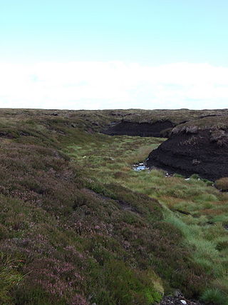
Arkengarthdale Gunnerside and Reeth Moors is a 7,634.72 hectares biological Site of Special Scientific Interest (SSSI) in the Yorkshire Dales between Arkengarthdale and Swaledale. The SSSI was first notified in June 1998 and is due to the blanket bog, heather moorland, and breeding bird populations such as merlin and golden plover.
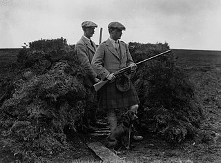
Driven grouse shooting is a field sport in the United Kingdom involving the shooting of red grouse. It is one of two forms of the sport, the other is walked-up shooting. Driven grouse shooting involves grouse being driven to fly over people with shotguns in fixed positions. In walked-up shooting the participants walk forward in a line and flush the birds as they go. Walked-up shooting is more physically demanding than a driven shoot and typically involves fewer birds being shot.

Many parts of Scotland are protected in accordance with a number of national and international designations because of their environmental, historical or cultural value. Protected areas can be divided according to the type of resource which each seeks to protect. NatureScot has various roles in the delivery of many environmental designations in Scotland, i.e. those aimed at protecting flora and fauna, scenic qualities and geological features. Historic Environment Scotland is responsible for designations that protect sites of historic and cultural importance. Some international designations, such as World Heritage Sites, can cover both categories of site.

Caithness Lochs is a protected wetland area in the historic county of Caithness in the far north of Scotland. With a total area of 1,379 hectares, it covers six freshwater lochs and a complex area of fen and swamp, and has been protected as a Ramsar Site since 1998.

The Kintyre Goose Roosts are a group of five oligotrophic hill lochs on the Kintyre peninsula in Argyll and Bute, western Scotland. With a total area of 312 hectares, they have been protected as a Ramsar Site since 1998.
The East Sanday Coast is a protected wetland area on and around the island of Sanday, the third-largest of the Orkney islands off the north coast of Scotland. With a total protected area of 1,515 hectares, the 55 kilometre stretch of coast includes rocky and sandy sections, sand dunes, machair habitats, intertidal flats, and saltmarsh. It has been protected as a Ramsar Site since 1997.
Fala Flow is an area of upland blanket bog on the edge of the Lammermuir Hills, in Midlothian, Scotland. Located north of the village of Fala, around 15 km south east of Edinburgh, an area of 318 hectares has been designated as a Ramsar Site since 1990.
Loch an Duin is a complex system of freshwater, brackish and sea lochs, tidal channels and islands, on and close to North Uist off the west coast of Scotland. An area of 2,621 hectares has been protected since 1990 as a Ramsar Site.
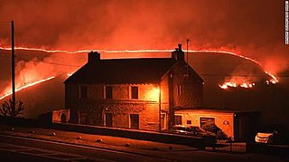
2019 United Kingdom wildfires were a series of wildfires that began on 26 February 2019 and ended on 18 May 2019. The series of wildfires was considered unusual due to the fact that they took place early in the year. Areas affected by the wildfires in 2019 included those that had already been burnt by wildfires during the summer of 2018. The fires have created many air pollution problems for the UK. The causes of most of the fires have been attributed to much higher than average temperatures and drought conditions that have prevailed since the spring of 2018. There were 137 wildfires larger than 25 hectares (250,000 m2) recorded in the United Kingdom in 2019. This beats the previous record of 79 from 2018.

South Tayside Goose Roosts is a composite wetland site to the west of Perth in central Scotland, covering a total of 331 hectares, which has been protected as a Ramsar Site since 1993. Incorporating three disconnected sections, separated by several kilometres, the site contains seven freshwater lochs along with other wetland habitats, including one of the largest raised bogs in the region.

Whitelee Moor is nature reserve of the Northumberland Wildlife Trust, in Northumberland, England, near Carter Bar. A large part of the moor is blanket bog.
