Greenleaf Peak

Last updated
Greenleaf Peak

Greenleaf Peak 2372s.JPG

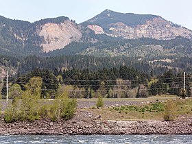
Southeast slope of Greenleaf Peak, Red Bluffs and the Columbia River from Bonneville Dam
Highest point
Elevation 3,424 ft (1,044 m)  NAVD 88 [1]
Coordinates 45°42′50″N121°58′01″W / 45.713974956°N 121.966995881°W / 45.713974956; -121.966995881 Coordinates: 45°42′50″N121°58′01″W / 45.713974956°N 121.966995881°W / 45.713974956; -121.966995881 [1]
Geography
USA Washington relief location map.jpg
Red triangle with thick white border.svg
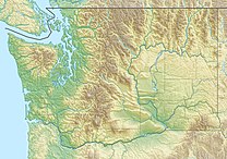
Greenleaf Peak
Location of Greenleaf Peak in Washington
Location Skamania County, Washington, U.S.
Parent range Cascade Range
Topo map USGS Bonneville Dam

Greenleaf Peak is a mountain in the Cascade Range in the U.S. state of Washington, located on the north side of the Columbia River near Table Mountain, in the Columbia River Gorge. The peak lies within the Columbia River Gorge National Scenic Area near Bonneville Dam. It is 3,424 feet (1,044 m) in elevation. [1] Botanist David Douglas climbed to the summit in September 1825, making this the first recorded mountain ascent in what is now Washington state. [2]

Cascade Range mountain range in western North America

The Cascade Range or Cascades is a major mountain range of western North America, extending from southern British Columbia through Washington and Oregon to Northern California. It includes both non-volcanic mountains, such as the North Cascades, and the notable volcanoes known as the High Cascades. The small part of the range in British Columbia is referred to as the Canadian Cascades or, locally, as the Cascade Mountains. The latter term is also sometimes used by Washington residents to refer to the Washington section of the Cascades in addition to North Cascades, the more usual U.S. term, as in North Cascades National Park. The highest peak in the range is Mount Rainier in Washington at 14,411 feet (4,392 m).

U.S. state constituent political entity of the United States

In the United States, a state is a constituent political entity, of which there are currently 50. Bound together in a political union, each state holds governmental jurisdiction over a separate and defined geographic territory and shares its sovereignty with the federal government. Due to this shared sovereignty, Americans are citizens both of the federal republic and of the state in which they reside. State citizenship and residency are flexible, and no government approval is required to move between states, except for persons restricted by certain types of court orders. Four states use the term commonwealth rather than state in their full official names.

Columbia River River in the Pacific Northwest of the United States

The Columbia River is the largest river in the Pacific Northwest region of North America. The river rises in the Rocky Mountains of British Columbia, Canada. It flows northwest and then south into the US state of Washington, then turns west to form most of the border between Washington and the state of Oregon before emptying into the Pacific Ocean. The river is 1,243 miles (2,000 km) long, and its largest tributary is the Snake River. Its drainage basin is roughly the size of France and extends into seven US states and a Canadian province. The fourth-largest river in the United States by volume, the Columbia has the greatest flow of any North American river entering the Pacific.

An aerial view of the south face of Greenleaf Peak. Greenleaf Peak, Washington.jpg
An aerial view of the south face of Greenleaf Peak.

Just south of the summit of Greenleaf Peak there is a dramatic escarpment called Red Bluffs, which connects Greenleaf Peak and Table Mountain. Approximately 1,300 feet (400 m) of the Eagle Creek formation are exposed at Red Bluffs. [3] The Red Bluffs escarpment was created by the repeated collapse of Greenleaf Peak and Table Mountain. Massive landslides have fallen from the mountains, creating a 12-to-14-square-mile (31 to 36 km2) area of debris called the Cascade Landslide Complex. The largest and most studied landslide is known as the Bonneville Slide, which created the Bridge of the Gods and Cascade Rapids [4] The topography of the landslide complex is uneven with roughly rolling hills and abrupt slopes. The whole area is inclined south toward and beyond the Columbia River. There may have been a cinder cone between Greenleaf Peak and Table Mountain which collapsed during the Bonneville Slide. [3]

Escarpment A steep slope or cliff separating two relatively level regions

An escarpment, or scarp, is a steep slope or long cliff that forms as an effect of faulting or erosion and separates two relatively level areas having differing elevations. Usually scarp and scarp face are used interchangeably with escarpment.

Bridge of the Gods (land bridge) natural dam formed by the Bonneville Slide, a landslide on the Columbia River, in Oregon in the United States

The Bridge of the Gods was a natural dam created by the Bonneville Slide, a major landslide that dammed the Columbia River near present-day Cascade Locks, Oregon in the Pacific Northwest of the United States. The river eventually breached the bridge and washed much of it away, but the event is remembered in local legends of the Native Americans as the Bridge of the Gods.

Cinder cone A steep conical hill of loose pyroclastic fragments around a volcanic vent

A cinder cone is a steep conical hill of loose pyroclastic fragments, such as either volcanic clinkers, cinders, volcanic ash, or cinder that has been built around a volcanic vent. They consist of loose pyroclastic debris formed by explosive eruptions or lava fountains from a single, typically cylindrical, vent. As the gas-charged lava is blown violently into the air, it breaks into small fragments that solidify and fall as either cinders, clinkers, or scoria around the vent to form a cone that often is symmetrical; with slopes between 30–40°; and a nearly circular ground plan. Most cinder cones have a bowl-shaped crater at the summit.

The Red Bluffs between Table Mountain and Greenleaf Peak. The Red Bluffs.jpg
The Red Bluffs between Table Mountain and Greenleaf Peak.

The propensity of the area south of Greenleaf Peak and Table Mountain to collapse in landslides is due to the Eagle Creek formation. The rocks of the formation cover approximately 30 miles (48 km) of the Columbia River Gorge east of Cape Horn and consist of a mixture of past landslides, volcanic mud flows and ash falls. The formation is topped with basalt. Water can percolate through the basalt and saturate the Eagle Creek formation. In places where the formation is relatively close to the surface and inclined downslope, such as near Greenleaf Peak and Table Mountain, water saturation can cause the formation's material to slide away, carrying the overlying basalt with it. [5]

Basalt A magnesium- and iron-rich extrusive igneous rock

Basalt is a mafic extrusive igneous rock formed from the rapid cooling of magnesium-rich and iron-rich lava exposed at or very near the surface of a terrestrial planet or a moon. More than 90% of all volcanic rock on Earth is basalt. Basalt lava has a low viscosity, due to its low silica content, resulting in rapid lava flows that can spread over great areas before cooling and solidification. Flood basalt describes the formation in a series of lava basalt flows.

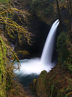
Between Greenleaf Peak and Table Mountain, and above the Red Bluffs, lies Greenleaf Basin. The basin averages 2,040 feet (620 m) in elevation and is covered with forested wetlands. Greenleaf Creek flows south through the basin before plunging as a waterfall over the Red Bluffs escarpment.

In the winter of 2007-2008, there was a large landslide on the south slope of Greenleaf Peak, in the state-owned Table Mountain Natural Resources Conservation Area. Some 3 to 5 acres (12,000 to 20,000 m2) of a timbered rocky cliff slid, burying approximately 30 acres (120,000 m2) of forest under rubble. The slide was estimated to be about 750 feet (230 m) wide and 0.5 miles (0.80 km) long. [5]

Related Research Articles

Intermontane Plateaus physiographic division of the United States

The Intermontane Plateaus of the Western United States is one of eight U.S. Physiographic regions (divisions) of the physical geography of the contiguous United States. The region is composed of intermontane plateaus and mountain ranges. It is subdivided into physiographic provinces, which are each subdivided into physiographic sections.

Cascades Rapids

The Cascades Rapids were an area of rapids along North America's Columbia River, between the U.S. states of Washington and Oregon. Through a stretch approximately 150 yards (140 m) wide, the river dropped about 40 feet (12 m) in 2 miles (3.2 km).

Skagit River river in Canada and the United States

The Skagit River is a river in southwestern British Columbia in Canada and northwestern Washington in the United States, approximately 150 mi (240 km) long. The river and its tributaries drain an area of 1.7 million acres (6900 km2) of the Cascade Range along the northern end of Puget Sound and flows into the sound.

Table Mountain (Skamania County, Washington) mountain in Washington, United States of America

Table Mountain is a peak rising on the north side of the Columbia River in Washington state, about 4 miles (6.4 km) north-northwest of Bonneville Dam. It is one of the most spectacular landmarks of the Columbia River Gorge. Its southeast face drops 2,400 feet (730 m) in less than one horizontal mile (1.6 km.), and is topped by an almost vertical 800-foot (240 m) cliff. Table Mountain is joined by the similar Greenleaf Peak to the northeast, and also by Hamilton Mountain to the southwest, which is lower,, but similarly steep and much closer to the Columbia. Together these peaks form an impressive group on the Washington side of the Gorge.

Eagle Creek (Multnomah County, Oregon) river in Oregon, United States of America

Eagle Creek is a creek located in Hood River County, Oregon, in the Columbia River Gorge. A tributary of the Columbia River, the creek flows for approximately 15 miles (24 km) from the Thrush Pond between Eagle Butte and Tanner Butte to its mouth near Bonneville Dam. The East Fork Eagle Creek is a major tributary that begins at Wahtum Lake and joins the main stem approximately 2/3 the way between the Thrush Pond and the Columbia River, separated by Indian Mountain.

Silver Star Mountain (Skamania County, Washington) mountain in Washington, United States of America

Silver Star Mountain is an extinct volcano of the Cascade Range in the U.S. state of Washington. Consisting of late Eocene to Oligocene epoch rock, it lies within the Gifford Pinchot National Forest. Long inactive, the volcano sits over three lithologic units, including the large Silver Star Granodiorite unit.

Larch Mountain (Multnomah County, Oregon)

Larch Mountain is an extinct volcano near Portland, Oregon. The name is misleading, as no western larch can be found there. It received that name when early lumbermen sold the noble fir wood as larch. The peak can be reached between May and November on paved Larch Mountain Road, 16 miles (26 km) east of Corbett, Oregon, although the road is closed during the winter and spring months.

Mount Meager massif mountain

The Mount Meager massif is a group of volcanic peaks in the Pacific Ranges of the Coast Mountains in southwestern British Columbia, Canada. Part of the Cascade Volcanic Arc of western North America, it is located 150 km (93 mi) north of Vancouver at the northern end of the Pemberton Valley and reaches a maximum elevation of 2,680 m (8,790 ft). The massif is capped by several eroded volcanic edifices, including lava domes, volcanic plugs and overlapping piles of lava flows; these form at least six major summits including Mount Meager which is the second highest of the massif.

Tualatin Mountains

The Tualatin Mountains are a range on the western border of Multnomah County, Oregon, United States. A spur of the Northern Oregon Coast Range, they separate the Tualatin Basin of Washington County, Oregon, from the Portland Basin of western Multnomah County and Clark County, Washington.

Mark O. Hatfield Wilderness

The Mark O. Hatfield Wilderness is a wilderness area located on the northern side of Mount Hood in the northwestern Cascades of the U.S. state of Oregon, near the Columbia River Gorge and within Mount Hood National Forest. Prior to Wilderness designation it was known as the Columbia Gorge Recreation Area.

West Crater

West Crater is a small lava dome with associated lava flows in southern Washington, United States. Located in Skamania County, it rises to an elevation of 4,131 feet (1,259 m), and forms part of the Cascade Volcanic Arc. It is also part of the Marble Mountain-Trout Creek Hill volcanic field, a little-known Quaternary volcanic field in the southern Cascades of Washington state. The area can be hiked, and can be accessed by roads in the Gifford Pinchot National Forest.

Saddle Mountains

The Saddle Mountains consists of an upfolded anticline ridge of basalt in Grant County of central Washington state. The ridge, reaching to 2,700 feet, terminates in the east south of Othello, Washington near the foot of the Drumheller Channels. It continues to the west where it is broken at Sentinel Gap before ending in the foothills of the Cascade Mountains.

Oregon Coast Range

The Oregon Coast Range, often called simply the Coast Range and sometimes the Pacific Coast Range, is a mountain range, in the Pacific Coast Ranges physiographic region, in the U.S. state of Oregon along the Pacific Ocean. This north-south running range extends over 200 miles (320 km) from the Columbia River in the north on the border of Oregon and Washington, south to the middle fork of the Coquille River. It is 30 to 60 miles wide and averages around 1,500 feet (460 m) in elevation above sea level. The coast range has three main sections, a Northern, Central, and Southern.

Cascades (ecoregion)

The Cascades ecoregion is a Level III ecoregion designated by the United States Environmental Protection Agency (EPA) in the U.S. states of Washington, Oregon, and California. Somewhat smaller than the Cascade mountain range for which it is named, the ecoregion extends north to Snoqualmie Pass, near Seattle, and south to Hayden Pass, near the Oregon-California border, including the peaks and western slopes of most of the High Cascades. A discontiguous section is located on Mount Shasta in California.

Trout Creek Hill mountain in United States of America

Trout Creek Hill is a small Pleistocene basaltic shield volcano in Washington, United States. Located in Skamania County, Trout Creek Hill rises to an elevation of 2,946 feet (898 m). It is part of the Cascade Volcanic Arc, located in the Marble Mountain-Trout Creek Hill volcanic field.

Yolla Bolly–Middle Eel Wilderness

The Yolla Bolly–Middle Eel Wilderness is a federally designated wilderness area in the Yolla Bolly Range of the southern Klamath Mountains and the Inner Northern California Coast Ranges, in Northern California.

Eagle Creek waterfalls

Eagle Creek is a tributary of the Columbia River in Multnomah and Hood River counties in the U.S. state of Oregon. It cuts through a narrow canyon in its 3,200 feet (980 m) descent to the Columbia River Gorge and is known for its concentration of 13 waterfalls in about 5 miles (8.0 km) distance. Eight major falls are on Eagle Creek and the East Fork Eagle Creek itself, while five are on its tributaries.

Bonneville flood

The Bonneville flood was a catastrophic flooding event in the last ice age, which involved massive amounts of water inundating parts of southern Idaho and eastern Washington along the course of the Snake River. Unlike the Missoula Floods, which also occurred during the same period in the Pacific Northwest, the Bonneville flood only happened once. The flood is believed to be the second largest in known geologic history.

References

  1. 1 2 3 "Greenleaf". NGS data sheet. U.S. National Geodetic Survey.
  2. Majors, Harry M. (1975). Exploring Washington. Van Winkle Publishing Co. p. 150. ISBN   978-0-918664-00-6.
  3. 1 2 "Table Mountain Natural Resources Conservation Area Management Plan" (PDF). Washing State Department of Natural Resources. Retrieved 30 December 2010.
  4. "The Volcanoes of Lewis and Clark". United States Geological Survey . Retrieved 2 October 2009.
  5. 1 2 Robinson, Erik (7 March 2008). "Hikers discover massive landslide in southwest Washington". The Seattle Times. Retrieved 2 October 2009.
Geographic Names Information System geographical database

The Geographic Names Information System (GNIS) is a database that contains name and locative information about more than two million physical and cultural features located throughout the United States of America and its territories. It is a type of gazetteer. GNIS was developed by the United States Geological Survey in cooperation with the United States Board on Geographic Names (BGN) to promote the standardization of feature names.

United States Geological Survey Scientific agency of the United States government

The United States Geological Survey is a scientific agency of the United States government. The scientists of the USGS study the landscape of the United States, its natural resources, and the natural hazards that threaten it. The organization has four major science disciplines, concerning biology, geography, geology, and hydrology. The USGS is a fact-finding research organization with no regulatory responsibility.