Greenmount, Greater Manchester

Last updated

Greenmount
Greenmount,peeltower,rain.jpg
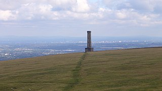
Peel Tower on Harcles Hill above Greenmount
Greater Manchester UK location map 2.svg
Red pog.svg
Greenmount
Location within Greater Manchester
OS grid reference SD777143
Metropolitan borough
Metropolitan county
Region
Country England
Sovereign state United Kingdom
Post town BURY
Postcode district BL8
Dialling code 01204
Police Greater Manchester
Fire Greater Manchester
Ambulance North West
UK Parliament
List of places
UK
England
Greater Manchester
53°37′37″N2°19′48″W / 53.627°N 2.330°W / 53.627; -2.330

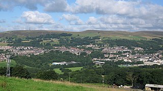
Greenmount is a village in Tottington in the West Pennine Moors, in the northern part of the Metropolitan Borough of Bury, in Greater Manchester, England.

Contents

Historically a part of Lancashire, Greenmount is 13 miles (21 km) north of Manchester, 1 mile (2 km) to the northeast of Tottington, and 2 miles (3 km) south of Ramsbottom.

History

Greenmount came into existence in 1848 when the Sunday School was built. It was originally spelt Green Mount. Greenmount was, in 1848, on the outskirts of Tottington. People who lived near to the Sunday School included the name of Greenmount in their address and gradually this was extended to the surrounding area and became the village name. The ward boundaries came into existence after the Local Government Act of 1894. They were changed in 1979. [C B Taylor, A History of Greenmount].

Governance

Since 1974, as part of the Local Government Act 1972, Greenmount has formed part of the Metropolitan Borough of Bury of Greater Manchester.

Geography

The village of Greenmount is 13 miles (20.9 km) north of Manchester.

Peel Tower, Harcles Hill Greenmount,peeltower,snow.jpg
Peel Tower, Harcles Hill

The village has a nonconformist church, Greenmount United Reformed Church.

Kirklees Trail / Former Railway Line

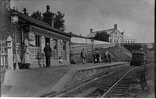
At one time Greenmount village was a stopping point from Bury to Holcombe Brook via a rail line operated by the Lancashire & Yorkshire Railway, this line was closed to passengers in 1968. The old rail line is now the central footpath through a park and nature trail through Kirklees Valley called Kirklees Trail, this trail provides an alternative flat route for pedestrians to access the neighbouring town of Tottington (the alternative route by road involves negotiating two steep hills via the A676 or 'Stormer Hill'). There is also a lake popular with fishermen, an impressive bridge over the river, a bird sanctuary (Greenmount Wild Bird Sanctuary) and a cricket club all situated along the trail. [1]

Notable people

Brookhouse Farm on Holcombe Road has a blue plaque marking it as the 17th century home of Henry Wood, a Quaker and supporter of Oliver Cromwell who emigrated to New Jersey where he founded the city of Woodbury.

The Manchester United teammates and brothers Gary and Phil Neville and their father Neville Neville played cricket at Greenmount Cricket club (in the Bolton Cricket League).

TV presenter (and Emmerdale actor) Lisa Riley was born and raised in Tottington. Antony Cotton, star of the soap opera Coronation Street, was also born and raised in the village.

Related Research Articles

<span class="mw-page-title-main">Bury, Greater Manchester</span> Market town in Greater Manchester, England

Bury is a market town on the River Irwell in the Metropolitan Borough of Bury, Greater Manchester, England. which had a population of 81,101 in 2021 while the wider borough had a population of 193,846.

<span class="mw-page-title-main">Metropolitan Borough of Bury</span> Borough of Greater Manchester, England

The Metropolitan Borough of Bury is a metropolitan borough of Greater Manchester in England. It is north of Manchester, to the east of Bolton and west of Rochdale. The borough is centred around the town of Bury but also includes other towns such as Ramsbottom, Tottington, Radcliffe, Whitefield and Prestwich. Bury bounds the Lancashire districts of Rossendale and Blackburn with Darwen to the north. With a population of 193,823 in 2021, it is the smallest borough in Greater Manchester.

<span class="mw-page-title-main">Greenfield, Greater Manchester</span> Village in Greater Manchester, England

Greenfield is a village in the civil parish of Saddleworth in the Metropolitan Borough of Oldham, in Greater Manchester, England. It is 4 miles (6.4 km) east of Oldham and 13 miles (21 km) north-east of Manchester. It is located in a broad rural area at the southern edge of the South Pennines; Dovestone Reservoir, Chew Reservoir and Greenfield Reservoir lie to the east of the village in the Peak District National Park.
<span class="mw-page-title-main">Ramsbottom</span> Town in Greater Manchester, England

Ramsbottom is a market town in the Metropolitan Borough of Bury, Greater Manchester, England. The population at the 2011 census was 17,872.

<span class="mw-page-title-main">Peel Monument, Ramsbottom</span> Commemorative monument

The Peel Monument at Ramsbottom, Lancashire, England, is one of two monuments in the area erected in memory of Prime Minister and founder of the police force Robert Peel, who was born in Bury. It is on Harcles Hill near Ramsbottom, 1100 feet above sea level. Because of its proximity to the village of Holcombe, Harcles Hill is more commonly known as Holcombe Hill and the monument as Holcombe or Peel Tower.

<span class="mw-page-title-main">Tottington, Greater Manchester</span> Human settlement in England

Tottington is a town in the Metropolitan Borough of Bury in Greater Manchester, England, on the edge of the West Pennine Moors.
<span class="mw-page-title-main">Holcombe, Greater Manchester</span> Human settlement in England

Holcombe is a village in Ramsbottom ward, Metropolitan Borough of Bury, in Greater Manchester, England. It is situated south of Haslingden, east of Edgworth, west of Ramsbottom, and north of Tottington. The name comes from the Celtic cwm meaning valley, and the Old English hol, meaning deep or hollow.

<span class="mw-page-title-main">Affetside</span> Village in the Metropolitan Borough of Bury, in Greater Manchester, England

Affetside is a village in Greater Manchester, England. Historically in Lancashire, it is in the Tottington ward of Bury Metropolitan Borough Council and the Bury North parliamentary constituency, in the West Pennine Moors.

<span class="mw-page-title-main">Castleton railway station</span> Railway station in Greater Manchester, England

Castleton railway station serves Castleton in the Metropolitan Borough of Rochdale, Greater Manchester, England. It is 8¾ miles (14 km) north of Manchester Victoria on the Caldervale Line operated and managed by Northern.

Brandlesholme is an area in the town of Bury in Greater Manchester, England. The boundary between Brandlesholme, Bury and the North Manor area of Bury is Wood Road Lane, close to the junction of Brandlesholme Road and Longsite Road.

<span class="mw-page-title-main">Hawkshaw, Greater Manchester</span> Human settlement in England

Hawkshaw is a village in the Metropolitan Borough of Bury, in Greater Manchester, England. Historically a part of Lancashire, it has a population of around 1,000 people. The village has a small shop and 2 pubs called The Red Lion and The Waggon and Horses.

Tottington Railway station served the town of Tottington in Greater Manchester, England. It opened in 1882 and continued to serve passengers until the line closed to passengers in 1952 and freight in 1963.
<span class="mw-page-title-main">Greenmount railway station</span> Former railway station in England

Greenmount Railway Station served the village of Greenmount in the Metropolitan Borough of Bury.

Holcombe Brook railway station was the terminus of the Bury to Holcombe Brook Line in England and served the village of Holcombe Brook in the Metropolitan Borough of Bury.

<span class="mw-page-title-main">Bury–Holcombe Brook line</span> United Kingdom legislation

The Bury–Holcombe Brook line was a 3+34-mile (6.0 km) single-track railway line which ran between Bury Bolton Street railway station and Holcombe Brook railway station via seven intermediate stations, Woodhill Road Halt, Brandlesholme Road Halt, Woolfold, Sunny Wood Halt, Tottington, Knowles Halt, and Greenmount.

<span class="mw-page-title-main">Shuttleworth, Greater Manchester</span> Hamlet in Greater Manchester, England

Shuttleworth is a hamlet at the northeastern extremity of the Metropolitan Borough of Bury, in Greater Manchester, England. It lies amongst the South Pennines, 4.3 miles (6.9 km) north of Bury and 0.9 miles (1.4 km) south of Edenfield; Scout Moor Wind Farm lies to the immediate east. Effectively a suburb of Ramsbottom, the M66 motorway divides Shuttleworth from the main core of that town.

<span class="mw-page-title-main">Kirklees Brook</span> River in Greater Manchester, England

Kirklees Brook is a minor river in Greater Manchester, England. It is 6.56 miles (10.556 km) long and including tributaries has a catchment area of 5.23 square miles (13.547 km2).

<span class="mw-page-title-main">Kirklees Valley Local Nature Reserve</span> Nature Reserve in Greater Manchester, England

Kirklees Valley Local Nature Reserve is a nature reserve in the Metropolitan Borough of Bury, that stretches from Greenmount in the north, Bury in the south, and Tottington in the west. It was declared a nature reserve in October 2010 under the 1949 National Parks and Access to the Countryside Act.

References

  1. "Kirklees Trail". Archived from the original on 27 September 2007.