Related Research Articles

Nash Lee is a hamlet in the parish of Ellesborough, in Buckinghamshire, England. It is located to the north of the village, about two miles west of Wendover.

The River Lynher flows through east Cornwall, England, and enters the River Tamar at the Hamoaze, which in turn flows into Plymouth Sound.

Beaumont Hill is a village in the borough of Darlington and the traditional and ceremonial counties of Durham in England, situated directly to the north of Darlington on the A167 road.

Calderbank is a village outside the town of Airdrie, North Lanarkshire, Scotland. It lies west of the M73, on the west bank of the North Calder Water. The village lies 13 miles (21 km) east of Glasgow city centre and around 34 miles (55 km) west of Edinburgh. Other nearby towns include: Airdrie, Coatbridge, Bellshill and Motherwell. It has a population of about 1,560 (mid-2020 est.)

The Wayfarer's Walk is a 71 mile long distance footpath in England from Walbury Hill, Berkshire to Emsworth, Hampshire.
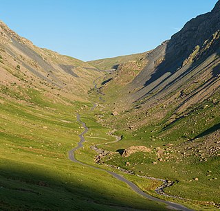
Honister Pass is a mountain pass in the English Lake District. It is located on the B5289 road, linking Seatoller, in the valley of Borrowdale, to Gatesgarth at the southern end of Buttermere. The pass reaches an altitude of 1,167 feet (356 m), making it one of the highest in the region, and also one of the steepest, with gradients of up to 1-in-4 (25%). The saddle at the watershed is known as Honister Hause, using the Cumbrian word hause for such a feature.

Brough and Shatton is a civil parish in Hope Valley in the High Peak district of Derbyshire, England. It is named for the two hamlets of Brough-on-Noe and Shatton. Brough is about 2 km, or just over 1 mile, west (upstream) of Shatton; both are on the River Noe, a tributary of the upper River Derwent. They lie within the Peak District National Park, about 15 miles west of Sheffield and 30 miles east of Manchester. According to the 2011 census, Brough and Shatton had a combined population of 136. There is a friendly rivalry between the two hamlets, which contest numerous sports competitions throughout the year.

Bulkworthy is a village and civil parish in the Torridge district of Devon, England, about 9 miles southwest of Great Torrington, and on the River Torridge. According to the 2001 census it had a population of 83. It is listed in the Domesday Book as Buchesworde.

Morwenstow is a civil parish in north Cornwall, UK. The parish abuts the west coast, about six miles (10 km) north of Bude and within the Cornwall Area of Outstanding Natural Beauty (AONB).
The River Croco is a small river in Cheshire in England. It starts as lowland field drainage west of Congleton, flows along the south edge of Holmes Chapel, and joins the River Dane at Middlewich. It is about 8 miles (13 km) long.

The A1068 is a road in northern England that runs from Seaton Burn in North Tyneside to Alnwick in Northumberland. The section between Ellington and Alnmouth is signposted as part of the Northumberland Coastal Route.

Upperton is a village in North Lanarkshire, Scotland, near Airdrie and Cumbernauld, about 20 miles (32 km) north-east of Glasgow. It lies close to the B803 between Greengairs and Slamannan. Other nearby roads include Hulks Road towards the A73, Fannyside Road to Abronhill and the road to Caldercruix via Longriggend. The Avon Water flows through the village and meets the Shielhill Burn, a tributary of the River Avon, just outside the village. William Forrest's 1816 map of Lanarkshire shows the site as Upper Town. The Ordnance Survey map sites "Uppertown" on Shiel Hill.

Hunsdon is a village and civil parish in Hertfordshire, England. It is around 5.5 miles (9 km) east of Ware and 5 miles (8 km) north-west of Harlow. The population of the village taken at the 2011 Census was 1,080.

Swan Island is a private mooring island in the Thames at Twickenham, in the London Borough of Richmond upon Thames, London, England. It is on the Tideway about 3⁄4 mile (1.2 km) north of and thus below Teddington Lock.
The River Inny is a small river in east Cornwall, United Kingdom. It is a tributary of the River Tamar and is about twenty miles (32 km) long from its source near Davidstow on the eastern flank of Bodmin Moor to its confluence with the Tamar at Inny Foot near Dunterton.

The River Llyfnant is a short river in Ceredigion, on the west coast of Wales. The river rises in the mountains south of Machynlleth, reaches the hill walk of Uwch Garreg and then plunges over a series of waterfalls known as Pistyll y Llyn, into a ravine, descending towards the River Dovey near Dovey Junction railway station.

The De Lank River is a small river in north Cornwall, England. It is a tributary of the River Camel and is approximately nine miles (14.5 km) long from its source on Bodmin Moor to its confluence with the Camel two miles (3 km) south of St Breward.
Greetham with Somersby is a civil parish in the East Lindsey district of Lincolnshire, England. It is situated approximately 3 miles (5 km) north-east from the market town of Horncastle.

The Afon Elan is a tributary of the River Wye which runs through the wide expanse of upland moors, traditionally known as Elenydd, in central Wales. Its valley is the Elan Valley. The name probably arises from elain meaning 'hind' or 'fawn' in reference perhaps to the rushing, bounding nature of its course.

The River Kensey is a river in east Cornwall, England, UK which is a tributary of the River Tamar.
References
- 1 2 Ordnance Survey: Landranger map sheet 71 Lanark & Upper Nithsdale (Map). Ordnance Survey. 2014. ISBN 9780319229712.
Coordinates: 55°31′N4°10′W / 55.517°N 4.167°W