Gregory, Michigan

Last updated

Gregory, Michigan
Gregory, Michigan June 2022.jpg
Looking north at the M-106 terminus at M-36
USA Michigan location map.svg
Red pog.svg
Gregory
Location within the state of Michigan
Usa edcp location map.svg
Red pog.svg
Gregory
Location within the United States
Coordinates: 42°27′30″N84°05′04″W / 42.45833°N 84.08444°W / 42.45833; -84.08444
CountryUnited States
State Michigan
County Livingston
Township Unadilla
Established1884
Elevation
935 ft (285 m)
Time zone UTC-5 (Eastern (EST))
  Summer (DST) UTC-4 (EDT)
ZIP code(s)
48137
Area code 734
GNIS feature ID627403 [1]

Gregory is an unincorporated community in Livingston County in the U.S. state of Michigan. [1] The community is located within Unadilla Township. As an unincorporated community, Gregory has no legally defined boundaries or population statistics of its own but does have its own post office with the 48137 ZIP Code. [2] [3]

Contents

Geography

U.S. Post Office in Gregory Gregory, MI post office.jpg
U.S. Post Office in Gregory
Unadilla Township Fire Department Unadilla Township Fire Department (Gregory).jpg
Unadilla Township Fire Department

Gregory is located within central Unadilla Township in southwest Livingston County. The community is located about 20 miles (32 km) southwest of the BrightonHowell area. [4] It is one of the westernmost communities included in the Detroit–Warren–Dearborn Metropolitan Statistical Area (Metro Detroit). Gregory sits at an elevation of 935 feet (285 m) above sea level. [1]

The community is centered along the northern terminus of M-106 (Main Street) at a curve along M-36. County highway D-32 (Church Street) also begins in Gregory at M-106 and runs for 8.4 miles (13.5 km) until merging into county highway D-19 near Pinckney. These are the only two county-designated highways in southeast Michigan. Other nearby communities include the unincorporated communities of Williamsville and Unadilla to the south, as well as Hell to the southeast. The village of Stockbridge is to the west in Ingham County, and the village of Pinckney is to the east. Richmond Field is a small general aviation airport located about 2.0 miles (3.2 km) southeast of the center of the community. [5]

Lakelands Trail State Park has a trailhead and passes through Gregory, which crosses M-36 in the center of the community at 188 Main Street. [6] Gregory State Game Area is located just northeast of the community. The state game area occupies 2,705 acres (10.95 km2) of land within Unadilla Township and Putnam Township to the east. [7] Unadilla State Wildlife Area is just to the southwest of the community. This wildlife area encompasses 1,163 acres (4.71 km2) of land mostly in Unadilla Township with a small portion extending south into Lyndon Township in Washtenaw County. [8]

Gregory contains its own post office that uses the 48137 ZIP Code. The post office serves a larger area that includes most of Unadilla Township, as well as a small portion of southern Iosco Township. The ZIP Code extends to the south in Washtenaw County and serves northern portions of Dexter Township and Lyndon Township. [2] [3] The Unadilla Township Offices and Police Department are located within the center of Gregory at 126 Webb Street. [9] The Unadilla Township Fire Department is also headquartered in Gregory at 116 Main Street. [10] The community is served by Stockbridge Community Schools to the west in Stockbridge. [11]

History

Historic image of Main Street in 1906 Gregory, Michigan (1906).jpg
Historic image of Main Street in 1906

The area was originally settled and occupied by the Halstead Gregory farmstead in Unadilla Township in 1884. At the same time, a Jackson branch Grand Trunk Railroad line came through the area and established a depot, which connected from Jackson in the southwest to Pinckney in the northeast. A post office first opened on March 14, 1884 with Halstead Gregory serving as the first postmaster. He also built a general store near the train depot. [12] [13] The post office has remained in operation ever since and is currently located at 114 East M-36 in the center of the community. [14]

Former train depot in 2022 Gregory, MI former train depot.jpg
Former train depot in 2022
Lakelands Trail trailhead in Gregory Lakelands Trail Gregory, MI.jpg
Lakelands Trail trailhead in Gregory

Among the oldest businesses in Gregory, Howlett Brothers Hardware opened in 1894 by Fred and T. Henry Howlett after purchasing tracts of land from the Halstead Gregory farmstead. The store itself was actually first constructed in 1864 and moved from nearby Unadilla about 3.0 miles (4.8 km) away. The business originally served as a mercantile and general store, and it supplied the community with its first indoor plumbing supplies. The hardware store has undergone numerous alterations under several owners, but the front entrance and steel door of the original 1864 structure remains intact. It is currently operating under local ownership as the Bramlett Hardware Company at the same location of 164 Main Street. [15]

The train depot was soon closed with the disestablishment of the railroad, and the railway lines were eventually removed altogether. Gregory is no longer served by railway lines. [16] Without the railroad, Gregory benefited from the creation of several highways. By early 1931, M-106, known locally as Main Street, was extended from Stockbridge and provided a direct route to Jackson. M-36 was also rerouted to run through Gregory, with M-106 having its northern terminus at M-36 in the center of the community. [17] [18] In 1970, D-32 was commissioned as one of the state's first county-designated highways. Known locally as Church Street, it runs through the community of Hell and connects to Pinckney. [19] In 1991, the pathway along the former railway line through Gregory was designated as Lakelands Trail State Park, which serves as a 22-mile-long (35 km) multi-use non-motorized trail that runs from Hamburg to Stockbridge. [6]

There are two designated Michigan State Historic Sites within the Gregory vicinity. The First Presbyterian Church is located at 20175 Williamsville Road. The congregation dates back to 1837, and the building itself dates back to 1846, although it was destroyed by a tornado in 1914 and rebuilt. [20] The Plainfield Methodist Church is another historic site located at 17485 East M-36. This congregation dates back to 1863. The first church was built in 1868 but burned down after being struck by lightning in 1906. The current church was constructed in 1907. [21] Established in 1837, the Unadilla Baseline Cemetery is a county-designated historic site located to the southeast of Gregory. Judson Dwight Collins was buried here after he died in 1852. Other graves date back to the Civil War period, although many of the earliest grave locations are unknown after the 1914 tornado. [22]

Notable people

Related Research Articles

<span class="mw-page-title-main">Livingston County, Michigan</span> County in Michigan, United States

Livingston County is a county in the U.S. state of Michigan. As of the 2020 Census, the population was 193,866. It is part of the Detroit-Warren-Dearborn, MI Metropolitan Statistical Area. The county seat and most populous city is Howell. The county was platted in 1833, but for three years remained assigned to Shiawassee and Washtenaw counties for revenue, taxation and judicial matters. It was formally organized in 1836. As one of Michigan's "Cabinet counties", a group of ten counties whose names honor members of President Andrew Jackson's Cabinet, it is named after former US Secretary of State Edward Livingston. Livingston County's location in Southeast Michigan offers residents relatively convenient access to the metropolitan centers of Detroit, Lansing, Ann Arbor, and Flint. Livingston County residents regularly commute to those centers, using the three major expressways which pass through the county: I-96, US 23, and M-59. Although continuing to be composed largely of bedroom communities, the county is experiencing and maintaining significant growth in both the service and industrial economic sectors. Major employers include Tribar, PepsiCo, Citizens Insurance, and ThaiSummit. The Brighton Recreation Area is in the county.

<span class="mw-page-title-main">Ingham County, Michigan</span> County in Michigan, United States

Ingham County is a county located in the U.S. state of Michigan. As of the 2020 Census, the population was 284,900. The county seat is Mason. Lansing, the state capital of Michigan, is largely located within the county. Lansing is the only state capital in the United States located in a county of which it is not also the seat of government. The county is home to Michigan State University, Lansing Community College, and the Class A minor league baseball team Lansing Lugnuts. Ingham County is included in the Lansing–East Lansing, MI Metropolitan Statistical Area. It is considered to be a part of Mid Michigan.

<span class="mw-page-title-main">Hamburg Township, Michigan</span> Civil township in Michigan, United States

Hamburg Township is a civil township of Livingston County in the U.S. state of Michigan. As of the 2010 census, the township population was 21,165. It is the most populated municipality in Livingston County.

<span class="mw-page-title-main">Unadilla Township, Michigan</span> Civil township in Michigan, United States

Unadilla Township is a civil township in the southwest corner of Livingston County, Michigan, United States. The population was 3,366 at the 2010 census.

<span class="mw-page-title-main">Lyndon Township, Michigan</span> Civil township in Michigan, United States

Lyndon Township is a civil township of Washtenaw County in the U.S. state of Michigan. The population was 2,720 at the 2010 census.

<span class="mw-page-title-main">M-21 (Michigan highway)</span> State highway in Michigan, United States

M-21 is an east–west state trunkline highway in the US state of Michigan connecting the cities of Grand Rapids and Flint. The highway passes through rural farming country and several small towns along its course through the Lower Peninsula. Following the course of a handful of rivers, M-21 also connects some of the state's freeways like Interstate 96 (I-96), US Highway 127 (US 127) and I-75. The highway is used by between 1,700 and 36,000 vehicles daily.

<span class="mw-page-title-main">M-52 (Michigan highway)</span> State highway in Michigan, United States

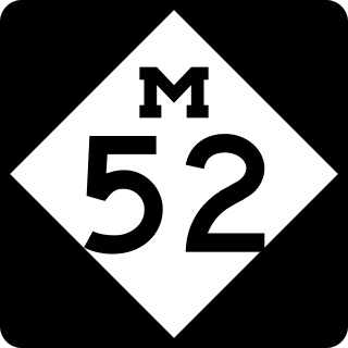
M-52 is a north–south state trunkline highway in the US state of Michigan. The southern terminus is on the Ohio border, where it continues as State Route 109. The highway passes through communities like Adrian, where it intersects US Highway 223 (US 223), Chelsea and Webberville along its 127.3-mile-long (204.9 km) course. It crosses some major rivers, including the River Raisin and the Shiawassee. The section of the highway between M-50 and Manchester was built as a limited-access highway. M-52's northern terminus is at M-46, nine miles (14 km) west of Saginaw.

<span class="mw-page-title-main">Topinabee, Michigan</span> Unincorporated community in Michigan, United States

Topinabee is an unincorporated community in Cheboygan County in the U.S. state of Michigan. The community is located within Mullet Township along the southwestern shores of Mullett Lake.

<span class="mw-page-title-main">M-59 (Michigan highway)</span> State highway in Michigan, United States

M-59 is an east–west state trunkline highway that crosses the northern part of Metropolitan Detroit in the US state of Michigan. It runs between Howell at Interstate 96 (I-96) and I-94 on the Chesterfield–Harrison township line near the Selfridge Air National Guard Base. While primarily a multi-lane surface highway, it is a full freeway from just east of downtown Pontiac near Opdyke Road to just east of the Mound Road/Merrill Road exit in Utica. The various surface highway segments are named either Highland Road, Huron Street or Hall Road, with the latter known as an area for shopping and dining. The rural sections west of Pontiac pass through Oakland County lake country, passing through two state recreational areas.

<span class="mw-page-title-main">Gould City, Michigan</span> Unincorporated community in Michigan, United States

Gould City is an unincorporated community in Mackinac County in the U.S. state of Michigan. The community is located within Newton Township. As an unincorporated community, Gould City has no legal autonomy of its own but does have its own post office with the 49838 ZIP Code.

<span class="mw-page-title-main">Curtis, Michigan</span> Unincorporated community in Michigan, United States

Curtis is an unincorporated community in Mackinac County in the U.S. state of Michigan. The community is located within Portage Township. As an unincorporated community, Curtis has no legally defined boundaries or population statistics of its own but does have its own post office with the 49820 ZIP Code.

Joe Hune is a politician from the U.S. state of Michigan.

<span class="mw-page-title-main">M-36 (Michigan highway)</span> State highway in Ingham and Livingston counties in Michigan, United States

M-36 is a state trunkline highway in the Lower Peninsula of the US state of Michigan that runs in a west–east direction from Mason to Whitmore Lake. The trunkline connects US Highway 127 (US 127) south of Lansing and US 23 north of Ann Arbor. The highway connects several smaller communities in the rural areas along its route. M-36 also runs concurrently with two other roadways, sharing pavement with M-52 and County Road D-19. According to traffic surveys in 2010, between 650 and 15,300 vehicles used the highway on average each day.

<span class="mw-page-title-main">M-106 (Michigan highway)</span> State highway in Michigan, United States

M-106 is a state trunkline highway in the Lower Peninsula of the US state of Michigan in and near the city of Jackson. M-106 travels in a southwest-to-northeast direction from Jackson to Gregory at a junction with M-36 just a few miles northwest of Hell. The highway was first designated in 1928 running north out of downtown Jackson. It connected U.S. Highway 12 (US 12) to the state prison and Bunkerhill Road. A pair of changes in the early 1930s resulted in the extension eastward to Gregory. From the 1960s until the early years of the 21st century, a section of M-106 in downtown Jackson was routed along one-way streets.

<span class="mw-page-title-main">Comins, Michigan</span> Unincorporated community in Michigan, United States

Comins is an unincorporated community in Oscoda County in the U.S. state of Michigan. The community is located within Clinton Township. As an unincorporated community, Comins has no legally defined boundaries or population statistics of its own but does have its own post office with the 48619 ZIP Code.

<span class="mw-page-title-main">McMillan, Michigan</span> Unincorporated community in Michigan, United States

McMillan is an unincorporated community in Luce County in the U.S. state of Michigan. The community is located along M-28 within Columbus Township. As an unincorporated community, McMillan has no legally defined boundaries or population statistics of its own but does have its own post office with the 49853 ZIP Code.

<span class="mw-page-title-main">Elmira, Michigan</span> Unincorporated community in Michigan, United States

Elmira is an unincorporated community in the U.S. state of Michigan. Located along M-32, the community is on the county line between Warner Township in Antrim County to the west and Elmira Township in Otsego County to the east.

<span class="mw-page-title-main">Engadine, Michigan</span> Unincorporated community in Michigan, United States

Engadine is an unincorporated community in Mackinac County in the U.S. state of Michigan. The community is located within Garfield Township. As an unincorporated community, Engadine has no legally defined boundaries or population statistics of its own but does have its own post office with the 49827 ZIP Code.

<span class="mw-page-title-main">Garnet, Michigan</span> Unincorporated community in Michigan, United States

Garnet is an unincorporated community in Mackinac County in the U.S. state of Michigan. The community is located within Hudson Township. As an unincorporated community, Garnet has no legally defined boundaries or population statistics of its own.

<span class="mw-page-title-main">Samaria, Michigan</span> Unincorporated community in Michigan, United States

Samaria is an unincorporated community in Monroe County in the U.S. state of Michigan. The community is located within Bedford Township. As an unincorporated community, Samaria has no legally defined boundaries or population statistics of its own but does have its own post office with the 48177 ZIP Code.

References

  1. 1 2 3 U.S. Geological Survey Geographic Names Information System: Gregory, Michigan
  2. 1 2 Google (June 24, 2022). "48137 ZIP Code map" (Map). Google Maps . Google. Retrieved June 24, 2022.
  3. 1 2 UnitedStatesZipCodes.org (2022). "ZIP Code 48137: Gregory" . Retrieved June 24, 2022.
  4. Michigan Economic Development Corporation (2022). "Pure Michigan: Gregory" . Retrieved July 11, 2022.
  5. Michigan DOT. "Gregory, Richmond Field" (PDF). Retrieved July 12, 2022.
  6. 1 2 Michigan Department of Natural Resources (2022). "Mike Levine Lakelands Trail State Park" . Retrieved July 1, 2022.
  7. Michigan Department of Natural Resources (March 30, 2016). "Gregory State Game Area" (PDF). Retrieved July 11, 2022.
  8. Michigan Department of Natural Resources (March 30, 2016). "Unadilla State Wildlife Area" (PDF). Retrieved July 11, 2022.
  9. Michigan Townships Association (2022). "Unadilla Twp., Livingston Co" . Retrieved July 11, 2022.
  10. Unadilla Township (2022). "Unadilla Township Fire Department" . Retrieved July 12, 2022.
  11. Michigan Geographic Framework (November 15, 2013). "Livingston County School Districts" (PDF). Retrieved July 4, 2022.
  12. Romig, Walter (October 1, 1986) [1973]. Michigan Place Names: The History of the Founding and the Naming of More Than Five Thousand Past and Present Michigan Communities (Paperback). Detroit, Michigan: Wayne State University Press. p. 240. ISBN   978-0-8143-1838-6.
  13. Michiganrailroad.com (2022). "Station: Gregory, MI" . Retrieved June 22, 2022.
  14. U.S. Postal Service (2022). "Gregory – Post Office" . Retrieved July 11, 2022.
  15. 1 2 "Gregory hardware retains the soul of 113-year-old business". MLive. Booth Newspapers. December 21, 2007. Retrieved July 13, 2022.
  16. Michigan Department of Transportation (March 2017). "Michigan's Railroad System: Railroads Operating in Michigan" (PDF). Retrieved June 3, 2022.
  17. Michigan State Highway Department & H.M. Gousha (November 1, 1930). Official Highway Service Map (Map). [c. 1:810,000]. Lansing: Michigan State Highway Department. OCLC   12701195, 79754957.
  18. Michigan State Highway Department & Rand McNally (May 15, 1931). Official Highway Service Map (Map). [c. 1:840,000]. Lansing: Michigan State Highway Department. § M11. OCLC   12701053.
  19. Michigan Department of State Highways (1970). Michigan, Great Lake State: Official Highway Map (Map). c. 1:918,720. Lansing: Michigan Department of State Highways. OCLC   12701120. §§ L12–M12;
    Michigan Department of State Highways (1971). Michigan, Great Lake State: Official Highway Map (Map). c. 1:918,720. Lansing: Michigan Department of State Highways. OCLC   12701120, 77960415. §§ L12–M12.
  20. The Historical Marker Database (June 9, 2021). "First Presbyterian Church" . Retrieved July 12, 2022.
  21. The Historical Marker Database (February 17, 2022). "Plainfield Methodist Church" . Retrieved July 12, 2022.
  22. The Historical Marker Database (April 27, 2021). "Unadilla Baseline Cemetery" . Retrieved July 16, 2022.
  23. U.S. Rowing Association (2022). "Gregg Hartsuff: University of Michigan" . Retrieved June 20, 2022.