
The Pennine Way is a National Trail in England, with a small section in Scotland. The trail stretches for 268 miles (431 km) from Edale, in the northern Derbyshire Peak District, north through the Yorkshire Dales and Northumberland National Park and ends at Kirk Yetholm, just inside the Scottish border. The path runs along the Pennine hills, sometimes described as the "backbone of England". Although not the United Kingdom's longest National Trail, it is according to The Ramblers "one of Britain's best known and toughest".
Ingleborough is the second-highest mountain in the Yorkshire Dales, England. It is one of the Yorkshire Three Peaks, and is frequently climbed as part of the Three Peaks walk. A large part of Ingleborough is designated as a Site of Special Scientific Interest and National Nature Reserve and is the home of a new joint project, Wild Ingleborough, with aims to improve the landscape for wildlife and people.

Helvellyn is a mountain in the English Lake District, the highest point of the Helvellyn range, a north–south line of mountains to the north of Ambleside, between the lakes of Thirlmere and Ullswater.

Skiddaw is a mountain in the Lake District National Park in England. Its 931-metre (3,054 ft) summit is the sixth-highest in England. It lies just north of the town of Keswick, Cumbria, and dominates the skyline in this part of the northern lakes. It is the simplest of the Lake District mountains of this height to ascend and, as such, many walking guides recommend it to the occasional walker wishing to climb a mountain. This is the first summit of the fell running challenge known as the Bob Graham Round when undertaken in a clockwise direction.
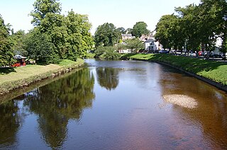
The River Eden is a river that flows through the Eden District of Cumbria, England, on its way to the Solway Firth.

Fairfield is a fell in the English Lake District. It is the highest of a group of hills in the Eastern Fells, standing to the south of the Helvellyn range.

Kirkby Stephen is a market town and civil parish in Cumbria, North West England. Historically part of Westmorland, it lies on the A685, surrounded by sparsely populated hill country, about 25 miles (40 km) from the nearest larger towns: Kendal and Penrith. The River Eden rises 6 miles (9.7 km) away in the peat bogs below Hugh Seat and passes the eastern edge of the town. At the 2001 census the parish had a population of 1,832. In 2011, it had a population of 1,522.

Place Fell is a hill in the English Lake District. It stands at the corner of the upper and middle reaches of Ullswater, with steep western flanks overlooking the villages of Glenridding and Patterdale.
The Cheviot is an extinct volcano and the highest summit in the Cheviot Hills and in the county of Northumberland. Located in the extreme north of England, it is 1+1⁄4 miles from the Scottish border and, with a height of 2,674 feet above sea-level, is located on the northernmost few miles of the Pennine Way, before the descent into Kirk Yetholm.
Orton is a village and civil parish in Cumbria, England. It lies 15 miles (24 km) south of Penrith, 8 miles (13 km) from Appleby-in-Westmorland and 1.5 miles (2.4 km) from the M6 motorway. The village is in the upper Lune Valley, at the foot of Orton Scar in the Orton Fells. The Lake District is nearby. The parish includes a wide area outside the village, and had a population of 594 in 2001, decreasing to 588 at the 2011 Census.

High Seat is a fell in the dale of Mallerstang, Cumbria. With a summit at 709 metres (2,326 ft), it is the fourth highest fell in the Yorkshire Dales after Whernside, Ingleborough and Great Shunner Fell. It is in the north-western part of the Dales, overlooking the deep trench of Mallerstang, and is usually climbed from this side.
Red Screes is a fell in the English Lake District, situated between the villages of Patterdale and Ambleside. It may be considered an outlier of the Fairfield group in the Eastern Fells, but is separated from its neighbours by low cols. This gives Red Screes an independence which is reflected in its prominence.

The Pennine Bridleway is a National Trail in Northern England.

Aisgill is the southernmost of the hamlets that comprise the parish of Mallerstang in the English county of Cumbria. It is on the B6259 road, at the head of Mallerstang dale, just before the boundary between Cumbria and North Yorkshire.

Mallerstang is a civil parish in the extreme east of Cumbria, and, geographically, a dale at the head of the upper Eden Valley. Originally part of Westmorland, it lies about 6 miles (9.7 km) south of the nearest town, Kirkby Stephen. Its eastern edge, at Aisgill, borders on North Yorkshire; and since August 2016 it has been within the Yorkshire Dales National Park.

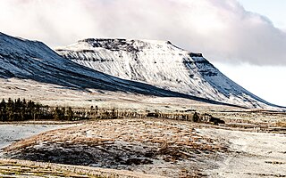
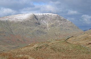
Wild Boar Fell is a mountain in the Yorkshire Dales National Park, on the eastern edge of Cumbria, England. At 2,323 feet (708 m), it is either the 4th-highest fell in the Yorkshire Dales or the 5th, depending on whether nearby High Seat (2,326 ft) is counted or not.

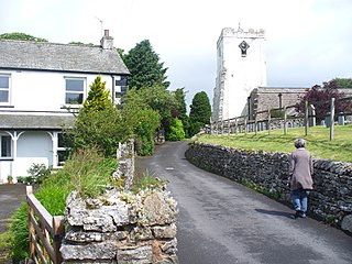
Outhgill is a hamlet in Mallerstang, Cumbria, England. It lies about 5 miles (8 km) south of Kirkby Stephen.

Pendragon Castle is a ruin located in Mallerstang Dale, Cumbria, south of Kirkby Stephen, and close to the hamlet of Outhgill, at grid reference NY781025. It stands above a bend in the River Eden, overlooked by Wild Boar Fell to the south-west and Mallerstang Edge to the east. It is a grade I listed building.

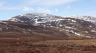
Hugh Seat is a mountain, or more accurately a fell, in Mallerstang on the eastern edge of Cumbria, England. It lies on the border between Cumbria and North Yorkshire.

Swarth Fell is an approximately 1 mile (1.5 km) stretch of high ground situated to the south of Wild Boar Fell, of which it is a continuation.
It is mostly within Mallerstang, Cumbria, but the boundary between Cumbria and North Yorkshire runs along its length, just to the west of the highest points.
