
The Mackinac Bridge is a suspension bridge that connects the Upper and Lower peninsulas of the U.S. state of Michigan. It spans the Straits of Mackinac, a body of water connecting Lake Michigan and Lake Huron, two of the Great Lakes. Opened in 1957, the 26,372-foot-long bridge is the world's 27th-longest main span and is the longest suspension bridge between anchorages in the Western Hemisphere. The Mackinac Bridge is part of Interstate 75 (I-75) and carries the Lake Michigan and Huron components of the Great Lakes Circle Tour across the straits; it is also a segment of the U.S. North Country National Scenic Trail. The bridge connects the city of St. Ignace to the north with the village of Mackinaw City to the south.

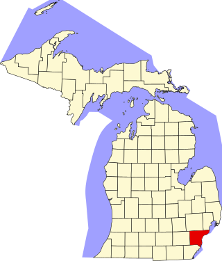
Wayne County is the most populous county in the U.S. state of Michigan. As of 2020, the United States Census placed its population at 1,793,561, making it the 19th-most populous county in the United States. The county seat is Detroit. The county was founded in 1796 and organized in 1815. Wayne County is included in the Detroit-Warren-Dearborn, MI Metropolitan Statistical Area. It is one of several U.S. counties named after Revolutionary War-era general Anthony Wayne.
Grosse Ile Township is a civil township of Wayne County in the U.S. state of Michigan. The population was 10,777 at the 2020 census.

Riverview is a city in Wayne County in the U.S. state of Michigan. The population was 12,486 at the 2010 census.

A toll bridge is a bridge where a monetary charge is required to pass over. Generally the private or public owner, builder and maintainer of the bridge uses the toll to recoup their investment, in much the same way as a toll road.

A swing bridge is a movable bridge that can be rotated horizontally around a vertical axis. It has as its primary structural support a vertical locating pin and support ring, usually at or near to its center of gravity, about which the swing span can then pivot horizontally as shown in the animated illustration to the right.
The Burlington County Bridge Commission is a public agency responsible for the operation and maintenance of several bridges in Burlington County, New Jersey, United States, across the Delaware River. It now manages eight bridges, including the Tacony-Palmyra Bridge, the Burlington-Bristol Bridge, and the Riverside-Delanco Bridge. Minor bridges operated by the Commission are the Pennsauken Creek Bridge, Pompeston Creek Bridge, Route 73 Overpass, Swede Run Bridge and the Twin Pipe Culvert, all along County Route 543.

The Bear Mountain Bridge, ceremonially named the Purple Heart Veterans Memorial Bridge, is a toll suspension bridge in New York State. It carries US 6 and US 202 across the Hudson River between Bear Mountain State Park in Orange County and Cortlandt in Westchester County. At completion in 1924 it was the longest suspension bridge in the world until this record was surpassed 19 months later by the Benjamin Franklin Bridge between Philadelphia and Camden, New Jersey. Like the Williamsburg Bridge in New York City, the approach spans of the Bear Mountain Bridge are unsuspended; only its main span is suspended by cables.
Jefferson Avenue is a 63.71-mile-long (102.53 km) scenic road along the eastern part of the Detroit metropolitan area in the southeastern part of the U.S. state of Michigan. It travels alongside Lake Erie, the Detroit River, and Lake St. Clair. This road also provides access to many recreational facilities in the area. West Jefferson Avenue is primarily commercial, while East Jefferson Avenue contains a historic residential district.

Downriver is a region of the Detroit metropolitan area in the U.S. state of Michigan. Most definitions of the region include the communities in Wayne County, south of Detroit, along the western shore of the Detroit River.
This is a list of the National Register of Historic Places listings in Wayne County, Michigan.

The Wayne County Bridge is a swing bridge that crosses the Trenton Channel in the Detroit River. Located in Wayne County, Michigan, it connects Grosse Ile Township to mainland Trenton and is one of two bridges connecting the island of Grosse Ile to the mainland — the other being the tolled Grosse Ile Toll Bridge to the north. Locally, it is also known as "The Free Bridge".

Mongaugon Township, is a former township of Wayne County in the U.S. state of Michigan. Quarries where gray limestone and celestine associated with calcite, fluorite, gypsum, epsomite, and rarely, sulfur were first worked by the French circa 1749. United States forces aided by Muskrat French defeated United Kingdom forces aided by Native Americans forces at the Battle of Monguagon during the War of 1812.

Sugar Island is a small island in the Detroit River between Grosse Ile and Boblo Island. Sugar Island is part of Grosse Ile Township, Wayne County, Michigan, United States, and lies about 0.5 miles (0.80 km) west of the border with Canada. Currently the island is uninhabited and was recently converted to a wildlife refuge by the US Fish and Wildlife service. The majority of the island is wooded and it is known for its white sandy beaches and easy access by boat.
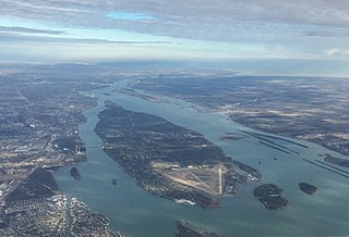
Grosse Ile is an American island in Wayne County in the U.S. state of Michigan. Located just west of the Canada–United States border in the Detroit River, it is the largest island in the river and the most-populated island in the state of Michigan. The island is administered by Grosse Ile Township.
Elizabeth Park is a county-owned public park in southeast Wayne County in the U.S. state of Michigan. The park is located in the city of Trenton along West Jefferson Avenue and the Detroit River just north of the Wayne County Bridge leading to Grosse Ile. Under private ownership until it was given to the county in 1919, Elizabeth Park is recognized as the first county park established in the state of Michigan.

The Parke Lane Road–Thorofare Canal Bridge is a bridge located on Parke Lane Road over the Thorofare Canal in Grosse Ile, Michigan. It was listed on the National Register of Historic Places in 2000.

Hickory Island is an inhabited island in the Detroit River. It is in Wayne County, in southeast Michigan. Its coordinates are 42°05′15″N83°09′20″W, and the United States Geological Survey gave its elevation as 581 ft (177 m) in 1980.

Stony Island is an island in the Detroit River, in southeast Michigan. It has been used for hunting and fishing as long as humans have inhabited the region; from the mid-19th century to the mid-20th century, it was the site of a small settlement and served as a central location for the construction of the Livingstone Channel, as well as various civil engineering projects involving the Detroit River. By the 1990s, it had become completely uninhabited; it is now open to the public and administered by the Michigan Department of Natural Resources.


