
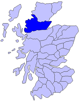
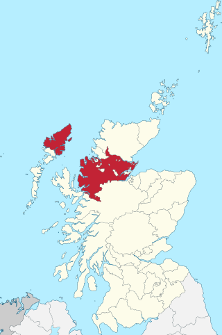
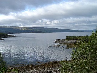
Gruinard Bay is a large remote coastal embayment, located 12 miles north of Poolewe, in northwestern Ross and Cromarty, and is in the former parish of Lochbroom, in the west coast of Scotland.
Gruinard Bay is a large remote coastal embayment, located 12 miles north of Poolewe, in northwestern Ross and Cromarty, and is in the former parish of Lochbroom, in the west coast of Scotland.
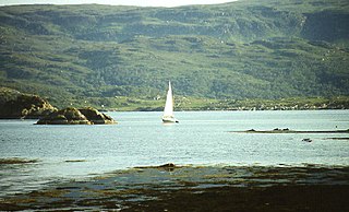
Gruinard Bay has a number of settlements, mainly located on the eastern shore of the bay. On the southeast corner, the small hamlet of Little Gruinard is located, where the similar named river leaves land. On the south coast, the small townships of Sand, First Coast and Second Coast are situated along the A832 road. On the western coast, the former fishing village of Laide, in the nook where the coast turns north, overlooks Gruinard Island to the northeast. Further up the west coast, the villages of Achgarve, the main village of Mellon Udrigle and the smaller crofting township of Opinan have a commanding view of the bay and Gruinard island.
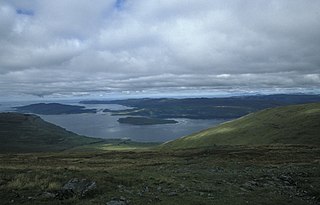
Gruinard Bay is formed from the boundary of Loch Broom to the northeast, encompasses the opening of Little Loch Broom to the east with Static Point further south, and on the west side by the Rubha Mòr peninsula, and Loch Ewe on the southwestern boundary. The bay measures 5.5 miles along its western shore, and 4.5 miles on its eastern shore, forming a L shape. [1]
The bay overlooks the infamous Gruinard Island, which is 0.68 miles (1 km) offshore, at the eastern side of the bay. The Summer Isles are visible to the northeast. [2]
Three fast flowing rivers flow into the Bay. Little Gruinard river, occasionally called River Little Gruinard, flows 4 miles from the Fionn Loch to enter Bay at the settlement of Little Gruinard, and Camas Gaineamhaich beach. River Gruinard river, flows a similar distance from the two lochs, the larger to the east, Loch Sealga and the smaller Loch Ghiubhsachain to the west, into the bay at the western side of Camas Gaineamhaich beach. The smaller stream of Inverianvie river, flows from the small loch, Loch à Mhadaidh Mòr and enters the bay between the two other rivers. [1] [2]
Ross is an area of Scotland. It was first recorded in the tenth century as a province. It was claimed by the Scottish crown in 1098, and from the 12th century Ross was an earldom. From 1661 there was a county of Ross, also known as Ross-shire, covering most but not all of the province, in particular excluding Cromartyshire. Cromartyshire was subsequently merged with the county of Ross in 1889 to form the county of Ross and Cromarty. The area is now part of the Highland council area.

The Dundonnell and Fisherfield Forest covers a large mountainous area of Wester Ross in the Northwest Highlands of Scotland, lying between Loch Maree and Little Loch Broom. It is sometimes nicknamed The Great Wilderness, as the area is entirely devoid of permanent settlements.

Wiay, pronounced "waya" is an uninhabited island in Loch Bracadale, off the coast of the Isle of Skye

The Isle of Ewe is a small Scottish island on the west coast of Ross and Cromarty. The island is inhabited by a single extended family, the Grants, who have lived at the current settlement on the leeward NE side of the island since the 19th century.
Ross-shire, or the County of Ross, was a county in the Scottish Highlands. It bordered Sutherland to the north and Inverness-shire to the south, as well as having a complex border with Cromartyshire, a county consisting of numerous enclaves or exclaves scattered throughout Ross-shire's territory. The mainland had a coast to the east onto the Moray Firth and a coast to the west onto the Minch. Ross-shire was named after and covered most of the ancient province of Ross, and also included the Isle of Lewis in the Outer Hebrides. The county town was Dingwall.

Loch Broom is a sea loch located in northwestern Ross and Cromarty, in the former parish of Lochbroom, on the west coast of Scotland. The small town of Ullapool lies on the eastern shore of the loch.

The A832 is a road in the Scottish Highlands, linking Cromarty, on the east coast, to Gairloch on the west coast, and beyond Gairloch to Braemore Junction. It is 126 miles (203 km) long and runs entirely in the former county of Ross and Cromarty. The road forms part of the Wester Ross Coastal Trail.

Eilean Mòr is the largest of the Crowlin Islands in the Inner Sound off the Isle of Skye, Scotland.

Fiskavaig or Fiscavaig is a picturesque crofting settlement on the north-west shore of the Minginish peninsula, Isle of Skye in the Highland Council area.
Badcall comprises two remote hamlets, called Lower Badcall and Upper Badcall. Upper Badcall, a crofting township, is the larger of the two and is situated on the western shore of Badcall Bay. Lower Badcall is located less than 1 mile to the east on the eastern shore of Badcall Bay. Badcall is on the west coast of Sutherland, Scottish Highlands and is in the Scottish council area of Highland.
Rubha Mòr is a remote peninsula in west Scotland, in the western region of Ross and Cromarty. The peninsula stretches from Greenstone Point in the north to the villages of Poolewe on the southern coastline and Laide on the northern coastline. The region immediately to the east of the peninsula contains Inchgarve Forest and Fionn Loch, which feeds via the Little Gruinard River into Gruinard Bay to the north. Further south are the forests of Letterewe overlooking Loch Maree, and northeast of Fionn Loch are the forests of Fisherfield and Strathnasheallag overlooking Loch na Sealga.
Loch na Keal, meaning Loch of the Kyle, or Narrows, also Loch of the Cliffs, is the principal sea loch on the western, or Atlantic coastline of the island of Mull, in the Inner Hebrides, Argyll and Bute, Scotland. Loch na Keal extends over 20 kilometres (12 mi) inland, almost bisecting Mull, and extending to within 5 km (3 mi) of the eastern shore. The loch gives its name to the Loch na Keal National Scenic Area, one of forty national scenic areas in Scotland.

Enard Bay is a large remote tidal coastal embayment, located 10.5 miles northwest of Ullapool, in northwestern Ross and Cromarty, Scottish Highlands in the west coast of Scotland. The mouth of the bay is about 4.5 miles across running from the head of Rubha Mòr peninsula at Rubna Na CòiGeach point to Rubna Na Brèige to the east.
Glenborrodale Bay is a remote tidal, 200° orientated, coastal embayment, located on the southern coastline of the west to east orientated Ardnamurchan peninsula, at the head of the sea loch Loch Sunart in western Scottish Highlands of Scotland. To the west is the large Ardgour peninsula, of which the Ardnamurchan and the larger Morven peninsula to the south is part of.
Glenmore Bay is a remote, tidal, 150° orientated, coastal embayment, located on the southern coastline of the west to east orientated Ardnamurchan peninsula, at the head of the sea loch Loch Sunart.

Lochbroom is a civil parish in Ross and Cromarty, Scotland, part of the Highland Unitary Authority area. Its name is Gaelic (Lochbraon), meaning "loch of rain showers". It completely surrounds Loch Broom, a sea loch extending from 7 miles (11 km) inland from the Minch on the west coast of Scotland. The former parish church stands at the head of this loch, hence the name of the parish. Lochbroom is also a Community council area, but the north-west corner of the parish is the Coigach community council area.
57°53′35″N5°29′31″W / 57.893°N 5.492°W
| | This Scottish location article is a stub. You can help Wikipedia by expanding it. |