Presidio County is a county located in the U.S. state of Texas. As of the 2010 census, its population was 7,818. Its county seat is Marfa. The county was created in 1850 and later organized in 1875. Presidio County is in the Trans-Pecos region of West Texas and is named for the ancient border settlement of Presidio del Norte. It is on the Rio Grande, which forms the Mexican border.

Jeff Davis County is a county in the U.S. state of Texas. As of the 2010 census, its population was 2,342. Its county seat is Fort Davis. The county is named for Jefferson Davis, who served as the 23rd United States Secretary of War in the 1850s, and as President of the Confederate States of America.

Hudspeth County is a county located in the U.S. state of Texas. As of the 2010 census, the population was 3,476. Its county seat is Sierra Blanca, and the largest community is Fort Hancock. The county is named for Claude Benton Hudspeth, a state senator and United States Representative from El Paso. It is northeast of the Mexico–U.S. border.

Culberson County is a county located in the U.S. state of Texas. As of the 2010 census, its population was 2,398. The county seat is Van Horn. Culberson County was founded in 1911 and organized the next year. It is named for David B. Culberson, a lawyer and Confederate soldier in the American Civil War.

Fredonia (Biscoe) is a city in Prairie County, Arkansas, United States. The population was 363 at the 2010 census.

Van Horn is a town in and the seat of Culberson County, Texas, United States. According to the 2010 census, Van Horn had a population of 2,063, down from 2,435 at the 2000 census. It is the westernmost incorporated community in the Central Time Zone part of the state of Texas.

Eldorado is a city in and the county seat of Schleicher County, Texas, United States. The population was 1,951 at the 2010 census. Eldorado is located on U.S. Highway 277 some 21 miles (34 km) north of Sonora and 43 miles (69 km) south of San Angelo, Texas.

Guadalupe Mountains National Park is an American national park in the Guadalupe Mountains, east of El Paso, Texas. The mountain range includes Guadalupe Peak, the highest point in Texas at 8,749 feet (2,667 m), and El Capitan used as a landmark by travelers on the route later followed by the Butterfield Overland Mail stagecoach line. The ruins of a stagecoach station stand near the Pine Springs visitor center. The restored Frijole Ranch contains a small museum of local history and is the trailhead for Smith Spring. The park covers 86,367 acres in the same mountain range as Carlsbad Caverns National Park, about 25 miles (40 km) to the north in New Mexico. The Guadalupe Peak Trail winds through pinyon pine and Douglas-fir forests as it ascends over 3,000 feet (910 m) to the summit of Guadalupe Peak, with views of El Capitan and the Chihuahuan Desert.

Guadalupe Peak, also known as Signal Peak, is the highest natural point in Texas, with an elevation of 8,751 feet (2,667 m) above sea level. It is located in Guadalupe Mountains National Park, and is part of the Guadalupe Mountains range in southeastern New Mexico and West Texas. The mountain is about 90 miles (140 km) east of El Paso and about 50 miles (80 km) southwest of Carlsbad, New Mexico. The peak rises more than 3,000 feet (910 m) above the arid floor of the Chihuahuan Desert.

El Capitan is a peak in Culberson County, Texas, located within Guadalupe Mountains National Park. The 10th-highest peak in Texas at 8,085 ft, El Capitan is part of the Guadalupe Mountains, an exposed portion of a Permian period reef uplifted and exposed by tectonic activity during the late Cretaceous period. The southern terminus of the Guadalupe Mountains, El Capitan looms over U.S. 62/180, where its imposing height and stark outline have made it one of the iconic images of the Trans-Pecos to generations of travelers.
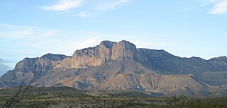
The Guadalupe Mountains are a mountain range located in West Texas and southeastern New Mexico. The range includes the highest summit in Texas, Guadalupe Peak, 8,751 ft (2,667 m), and the "signature peak" of West Texas, El Capitan, both of which are located within Guadalupe Mountains National Park. The Guadalupe Mountains are bordered by the Pecos River valley and Llano Estacado to the east and north, Delaware Mountains to the south, and Sacramento Mountains to the west.
In the geologic timescale, the Roadian is an age or stage of the Permian. It is the earliest or lower of three subdivisions of the Guadalupian epoch or series. The Roadian lasted between 272.95 and 268.8 million years ago (Ma). It was preceded by the Kungurian and followed by the Wordian.
Pine Creek is an 18.4-mile-long (29.6 km) tributary of Penns Creek in central Pennsylvania in the United States. Via Penns Creek, it is part of the Susquehanna River watershed.
Thordenskjold Township is a civil township in Barnes County, North Dakota, United States. As of the 2000 census, its population was 79.

The Delaware River (Texas) or Delaware Creek is an intermittent stream that rises in Guadalupe Mountains National Park about 8 kilometres (5.0 mi) west of Pine Springs and 3 kilometres (1.9 mi) north of Guadalupe Peak in northwestern Culberson County, Texas. It flows into the Pecos River in New Mexico, 5 kilometres (3.1 mi) north of the border with Texas.
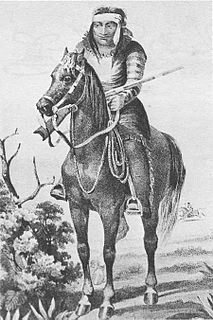
The Battle of the Diablo Mountains was an October 1854 engagement between the U.S. Army and the Lipan Apache. A small force of Mounted Rifles attacked a much larger force of Lipan Apaches at the base of the Diablo Mountains in Texas.

The Guadalupe Mountains of Hidalgo County are a 13 mi (21 km) long, sub–range in southwest Hidalgo County, New Mexico, adjacent the southeast border of Arizona's Cochise County. A small portion of the range is in Cochise County, namely the outlet of Guadalupe Canyon, famous for the Guadalupe Canyon Massacre. The very southern end of the range is also in the border region of Sonora, just north of Federal Highway 2.
Guadalupe Pass is a mountain pass located in the Guadalupe Mountains of Hidalgo County, New Mexico. It lies at an elevation of 5075 feet or 1547 m.

Bush Mountain, at an elevation of 8,631 feet (2,631 m) is the second highest peak in the U.S. state of Texas. Located in the Guadalupe Mountains of Culberson County, Bush Mountain is about 2.87 miles (4.62 km) northwest of Guadalupe Peak, its nearest higher neighbor. Its proximity to Guadalupe Peak gives Bush Mountain the 22nd greatest prominence of any mountain in Texas at 951 feet (290 m). Bush Mountain is within the Guadalupe Mountains Wilderness of Guadalupe Mountains National Park and can only be accessed via hiking or horseback.
Cooke's Wagon Road or Cooke's Road was the first wagon road between the Rio Grande and the Colorado River to San Diego, through the Mexican provinces of Nuevo México, Chihuahua, Sonora and Alta California, established by Philip St. George Cooke and the Mormon Battalion, from October 19, 1846 to January 29, 1847 during the Mexican–American War. It became the first of the wagon routes between New Mexico and California that with subsequent modifications before and during the California Gold Rush eventually became known as the Southern Trail or Southern Emigrant Trail.