Apra Harbor, also called Port Apra, is a deep-water port on the western side of the United States territory of Guam. It is considered one of the best natural ports in the Pacific Ocean. The harbor is bounded by Cabras Island and the Glass Breakwater to the north and the Orote Peninsula in the south. Naval Base Guam and the Port of Guam are the two major users of the harbor. It is also a popular recreation area for boaters, surfers, scuba divers, and other recreationalists.

The Sterling Highway is a 138-mile-long (222 km) state highway in the south-central region of the U.S. state of Alaska, leading from the Seward Highway at Tern Lake Junction, 90 miles (140 km) south of Anchorage, to Homer. To assist in agricultural transport and also open areas to tourism, work began on the Sterling Highway in 1946 to connect the Kenai Peninsula agricultural area with Seward. This highway honors Hawley W. Sterling, lifetime ARC engineer who served as assistant chief engineer from 1932 until his death in 1948.

Piti is a village located on the central west coast of the United States territory of Guam. It contains northern and eastern coastlines of Apra Harbor, including Cabras Island, which has the commercial Port of Guam and the island's largest power plants. Piti was a pre-Spanish CHamoru village and, after Spanish colonization, became the primary port town on Guam. The town was largely destroyed during the 1944 liberation of Guam and the population relocated during the wartime construction of Apra Harbor.

State Route 279 is a primary state highway in the U.S. state of Virginia. Known as Great Neck Road, the state highway runs 5.55 miles (8.93 km) from U.S. Route 58 north to US 60 within the independent city of Virginia Beach.

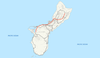
Guam Highway 1 (GH-1), also known as Marine Corps Drive, is one of the primary automobile routes in the United States territory of Guam. It runs in a southwest-to-northeast direction, from the main gate of Naval Base Guam in the southwestern village of Santa Rita in a northeasterly direction to the main gate of Andersen Air Force Base in the village of Yigo. It passes through Guam's capital, Hagåtña, as well as intersecting other territorial highways. The highway runs through tropical forest, urbanized commercial areas, and residential neighborhoods. The US military upgraded and extended the road starting in 1941. Construction ceased with the Japanese invasion in December 1941 and resumed after the Second Battle of Guam in 1944. The highway was formally dedicated to the U.S. Marine Corps by the governor in 2004.
Guam Highway 2 is one of the primary automobile routes in the United States territory of Guam.
Guam Highway 4 (GH-4) is one of the primary automobile highways in the United States territory of Guam.
Guam Highway 3 (GH-3) is one of the primary automobile highways in the United States territory of Guam.
Guam Highway 5 (GH-5) is one of the primary automobile highways in the United States territory of Guam.
Guam Highway 7 (GH-7) is one of the primary automobile highways in the United States territory of Guam.
Guam Highway 8 (GH-8) is one of the primary automobile highways in the United States territory of Guam.
Guam Highway 11 (GH-11) is one of the primary automobile highways in the United States territory of Guam.
Guam Highway 9 (GH-9) is one of the primary automobile highways in the United States territory of Guam.
Guam Highway 10 (GH-10) is one of the primary automobile highways in the United States territory of Guam.
Guam Highway 16 (GH-16), also named Army Drive, is one of the primary automobile highways in the United States territory of Guam.
Guam Highway 10A (GH-10A) is one of the primary automobile highways in the United States territory of Guam.
Guam Highway 17 (GH-17) is one of the primary automobile highways in the United States territory of Guam.
Guam Highway 15 (GH-15) is one of the primary automobile highways in the United States territory of Guam.
Guam Highway 14 (GH-14) is one of the primary automobile highways in the United States territory of Guam.
Tourist Drives in Western Australia are routes through areas of scenic or historic significance, designated by route markers with white numbers on a brown shield. Tourist Drives were introduced into Western Australia while Eric Charlton was the state government Minister for Transport in the 1990s. The 28 numbered routes collectively traverse more than 2,000 kilometres (1,200 mi) across the state. In addition to the Tourist Drives, there are unnumbered routes such as the Golden Pipeline Heritage Trail, and local governments may designate and maintain local scenic drives, generally unnamed and unnumbered.


