The Orinoco is one of the longest rivers in South America at 2,250 kilometres (1,400 mi). Its drainage basin, sometimes known as the Orinoquia, covers 989,000 km2 (382,000 sq mi), with 76.3 percent of it in Venezuela and the remainder in Colombia. It is the fourth largest river in the world by discharge volume of water. The Orinoco River and its tributaries are the major transportation system for eastern and interior Venezuela and the Llanos of Colombia. The environment and wildlife in the Orinoco's basin are extremely diverse.
Guainía is a department of Eastern Colombia. It is in the east of the country, bordering Venezuela and Brazil. Its capital is Inírida. In 1963 Guainía was split off from Vaupés department. The northern part and the Inírida River are included in the Orinoco basin; the rest is part of the Amazon basin. The Guaviare River is the main area of colonization; many colonos come from the Colombian Andean zone, most of them from Boyacá. They are followed by the llaneros, people from the Eastern plains (Llanos). The population is mainly composed of Amerindians, and the largest ethnic groups are the Puinaves and the curripacos. There are a total of 24 ethnic groups in the department; many of them speak four Indigenous languages besides Spanish and Portuguese.

Guaviare is a department of Colombia. It is in the southern central region of the country. Its capital is San José del Guaviare. Guaviare was created on July 4, 1991, by the new Political Constitution of Colombia. Up until that point, it was a national territory that operated as a commissariat, segregated from territory of the then Commissariat of Vaupés on December 23, 1977.

Vaupés is a department of Southeastern Colombia in the jungle covered Amazonía Region. It is located in the southeast part of the country, bordering Brazil to the east, the department of Amazonas to the south, Caquetá to the west, and Guaviare, and Guainía to the north; covering a total area of 54,135 km2. Its capital is the town of Mitú. As of 2018, the population was 40,797, making it the least populous department in Colombia.

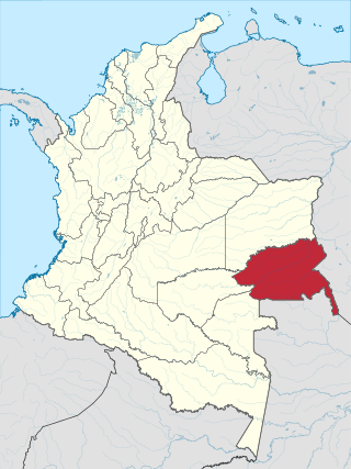
Vichada Department is a department of the Republic of Colombia in South America. Vichada is located in the eastern plains of Colombia, in the Orinoquía Region within the Orinoco river basin bordering the Bolivarian Republic of Venezuela to the north and east. To the north the department also borders with Arauca Department, to the northwest with Casanare Department, to the west with Meta Department, to the southwest narrowly bordering with Guaviare Department and to the south with Guainía Department. The department is the second largest in Colombia and scarcely populated in comparison to other departments.

The Llanos is a vast tropical grassland plain situated to the east of the Andes in Colombia and Venezuela, in northwestern South America. It is an ecoregion of the tropical and subtropical grasslands, savannas, and shrublands biome.

Panaque nigrolineatus, the royal panaque, royal plec, or royal pleco, is an herbivorous freshwater armored catfish native to Brazil, Colombia and Venezuela where it occurs in the Orinoco and Amazon basins. It is known for being one of the few fish that digest wood. It grows to a length of 43.0 centimetres (16.9 in) and is a popular aquarium fish.

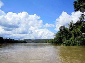
The Guaviare is a tributary of the Orinoco in Colombia. It flows together with the upper Orinoco, which it clearly surpasses in length and water flow. Thus, the Guaviare is hydrologically the main stream of the Orinoco system.
Serranía de la Macarena is an isolated mountain range located in the Meta Department, Colombia. It was named after the Virgin of Hope of Macarena. The mountains are separated by about 40 km (25 mi) at their northern extreme from the East Andes. The range is orientated from north to south and is 120 km (75 mi) in length and 30 km (19 mi) wide. The highest peak reaches 2,615 m (8,579 ft) and is the highest point of the Orinoquía Region. The first national reserve in Colombia was established in the central part of the mountain range in accordance with a Congressional Law promulgated in 1948. The status of National Natural Park was designated in 1971 and the protected area encompasses 6,200 km2 (2,400 sq mi).

Amazonía region in southern Colombia comprises the departments of Amazonas, Caquetá, Guainía, Guaviare, Putumayo and Vaupés, and covers an area of 483,000 km², 35% of Colombia's total territory. The region is mostly covered by tropical rainforest, or jungle, which is a part of the greater Amazon rainforest.

Cumaribo is a town and municipality located in the Department of Vichada, Republic of Colombia. Cumaribo was founded by Jose Nicolino Mattar in 1959.

Because of its natural structure, Colombia can be divided into six distinct natural regions. These consist of the Andean Region, covering the three branches of the Andes mountains found in Colombia; the Caribbean Region, covering the area adjacent to the Caribbean Sea; the Pacific Region adjacent to the Pacific Ocean; the Orinoquía Region, part of the Llanos plains mainly in the Orinoco river basin along the border with Venezuela; the Amazon Region, part of the Amazon rainforest; and finally the Insular Region, comprising the islands in both the Atlantic and Pacific Oceans. Colombia is located in South America.

Jorge Enrique González Torres Airport is an airport serving San José del Guaviare, the capital of the Guaviare Department of Colombia. The runway is just north of the town and parallels the Guaviare River.
Vaupés River is a tributary of the Rio Negro in South America. It rises in the Guaviare Department of Colombia, flowing east through Guaviare and Vaupés Departments. It forms part of the international border between the Vaupés department of Colombia and the Amazonas state of Brazil. On the border it merges with the Papurí River and becomes known as the Uaupés. In 1847 an explorer saw a rapid which hurled its waves 12 or 15 metres in the air, "as if great subaqueous explosions were taking place." The river continues on east through the Alto Rio Negro Indigenous Territory until it flows into the Rio Negro at São Joaquim, Amazonas. Vaupés is a blackwater river.

The Inírida is a river in the north-west of South America, in the territory of Colombia, the largest tributary of the Guaviare.

The Ariari River is a river of Colombia, located entirely within the Meta Department. Part of the Orinoco River basin, it merges with the Guayabero River to forms the Guaviare River, one of the principle tributaries of the Orinoco.

The Negro–Branco moist forests (NT0143) is an ecoregion of tropical moist broadleaf forest to the east of the Andes in southern Venezuela, eastern Colombia and northern Brazil, in the Amazon biome. It lies on the watershed between the Orinoco and Rio Negro basins. It includes both blackwater and whitewater rivers, creating different types of seasonally flooded forest. The vegetation is more typical of the Guiana region than the Amazon.
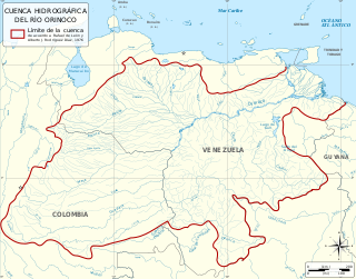
The Orinoco Basin is the part of South America drained by the Orinoco river and its tributaries. The Orinoco watershed covers an area of about 990000 km2, making it the third largest in South America, covering most of Venezuela and eastern part of Colombia.
Chaetostoma formosae is a species of catfish in the family Loricariidae. It is native to South America, where it occurs in the basins of the Meta River and the Guaviare River in the Orinoco drainage in the departments of Meta and Casanare in Colombia. The species reaches 9.7 cm SL. This species is sometimes seen in the aquarium trade, where it is known as the rubberlip pleco or referred to by its L-number, L-444.
Farlowella mitoupibo is a species of catfish in the family Loricariidae. It is native to South America, where it occurs in the upper Guaviare River, which is part of the Orinoco basin in Colombia. The species reaches at least 20.96 cm in standard length. It was described in 2016 by Gustavo A. Ballen, Alexander Urbano-Bonilla, and Jhon Zamudio. Its specific name, mitoupibo, is derived from the Guahibo name for the species. FishBase does not yet list this species.