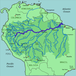
Map of the Amazon River drainage basin with the Amazon River highlightedThe Amazon River drainage basin; with the Casiquiare River, a distributary of the Orinoco River flowing southward into the Negro River, in Venezuela, South America. As such, it forms a unique natural canal between the Orinoco and Amazon river systems. That links two major river systems, a so-called bifurcation.
This page is based on this Wikipedia article Text is available under the CC BY-SA 4.0 license; additional terms may apply. Images, videos and audio are available under their respective licenses.