
The Orinoco is one of the longest rivers in South America at 2,250 kilometres (1,400 mi). Its drainage basin, sometimes known as the Orinoquia, covers 989,000 km2 (382,000 sq mi), with 76.3 percent of it in Venezuela and the remainder in Colombia. It is the fourth largest river in the world by discharge volume of water. The Orinoco River and its tributaries are the major transportation system for eastern and interior Venezuela and the Llanos of Colombia. The environment and wildlife in the Orinoco's basin are extremely diverse.

Santiago de Cali, or Cali, is the capital of the Valle del Cauca department, and the most populous city in southwest Colombia, with 2,227,642 residents according to the 2018 census. The city spans 560.3 km2 (216.3 sq mi) with 120.9 km2 (46.7 sq mi) of urban area, making Cali the second-largest city in the country by area and the third most populous after Bogotá and Medellín. As the only major Colombian city with access to the Pacific Coast, Cali is the main urban and economic center in the south of the country, and has one of Colombia's fastest-growing economies. The city was founded on 25 July 1536 by the Spanish explorer Sebastián de Belalcázar.

Darién is a province in Panama whose capital city is La Palma. With an area of 11,896.5 km2 (4,593.3 sq mi), it is located at the eastern end of the country and bordered to the north by the province of Panamá and the region of Kuna Yala. To the south, it is bordered by the Pacific Ocean and Colombia. To the east, it borders Colombia; to the west, it borders the Pacific Ocean and the province of Panama.

The Mississippi River is a tributary of the Ottawa River in Eastern Ontario, Canada which has no relation with the Mississippi River in the United States. It is 200 kilometres (120 mi) in length from its source at Mackavoy Lake, has a drainage area of 4,450 square kilometres (1,720 sq mi), and has a mean discharge of 40 cubic metres per second (1,400 cu ft/s). There are more than 250 lakes in the watershed.

The Caroní River is the second most important river of Venezuela, the second in flow, and one of the longest, 952 kilometres (592 mi) from the Kukenan tepui through to its confluence with the Orinoco River. The name "Caroní" is applied starting from the confluence of the Kukenan with the Yuruaní River at 182 kilometres (113 mi) from the source of the Kukenan and 770 kilometres (480 mi) from its discharge in the Orinoco. The confluence takes place in Bolivar State.

The Lerma River is Mexico's second longest river.

The Cordillera Occidental is the lowest in elevation of the three branches of the Colombian Andes. The average altitude is 2,000 m (6,600 ft) and the highest peak is Cerro Tatamá at 4,100 m (13,500 ft). The range extends from south to north dividing from the Colombian Massif in Nariño Department, passes north through Cauca, Valle del Cauca, Risaralda, Chocó, and Caldas Departments to the Paramillo Massif in Antioquia and Córdoba Departments. The cordillera is paralleled on the east by the Cauca river. From this massif the range divides further to form the Serranías de Ayapel, San Jerónimo and Abibe. Only to recede into the Caribbean plain and the Sinú River valley.

The Jáchal River is a river in the province of San Juan, Argentina. It is part of the Desaguadero River basin, and one of the most important permanent watercourses in the province, with an average flow of 9 cubic metres per second (320 cu ft/s). It is born from the confluence of the Río de la Palca and the Blanco River, in the northwest of San Juan.
Jamundí is a town and municipality in the Department of Valle del Cauca, Colombia.
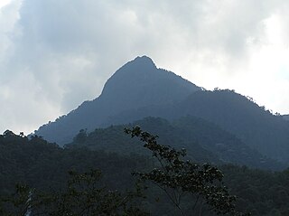
Farallones de Cali is a cluster of mountains in the West Andes of Colombia. It is located west of the city of Cali and gives rise to many of the rivers that provide water and electricity to Cali. The PNN Farallones de Cali encompasses 150,000 ha (580 sq mi) in the mountains as well as much of the Pacific slope and is an area of very high biodiversity. The average temperature ranges from 25 °C (77 °F) in the tropical foothills to 5 °C (41 °F) in the páramo. In this territory are located the district of Pichinde, Andes and Leonera, and two villages Penas Blancas and Lomas de la Cajita.
The Mira River originates in the Andes of Ecuador and flows to the Pacific Ocean in Colombia. For a few kilometers it forms the border between the two countries. The upper course of the Mira is called the Chota River and is notable for its Afro-Ecuadorian inhabitants, its bomba music, and the large number of internationally prominent soccer players it has produced.
The Tamá National Natural Park is a national park located in the Tamá Massif of the Andean Region of Colombia, between the municipalities Toledo and Herrán, in the department of Norte de Santander, in the northeastern part of the Eastern Ranges of the Colombian Andes. One of the main attractions of the park is a 820-metre-high (2,690 ft) waterfall, one of the world's highest.

The Metro Vancouver watersheds, also known as the Greater Vancouver watersheds, supply potable water to approximately 2.7 million residents in the Lower Mainland of British Columbia. They provide tap water to a land area covering more than 2,600 square kilometres (1,000 sq mi), serving a total of 21 member municipalities, one electoral district, and one treaty First Nation. From west to east, the watersheds are the Capilano, the Seymour, and the Coquitlam. They are located in the North Shore Mountains and Coquitlam Mountain, respectively. Each watershed possesses a reservoir for water storage purposes, under the control of Metro Vancouver. The reservoirs are supplied by about 3.5 metres (11 ft) of rain and 4.5 metres (15 ft) of snowpack annually. Two additional off-catchment areas under control of Metro Vancouver contribute to the water supply. The watersheds have a long history of controversies surrounding logging, highway development, and salmon run conservation.

The Angat Watershed Forest Reserve is a conservation area that protects the drainage basin in the southern Sierra Madre range north of Metro Manila in the Philippines where surface water empties into the Angat River and its distributaries. It is spread over an area of 62,309 hectares in the eastern portion of Bulacan and northern Rizal province at an altitude of between 490 and 1,206 metres. The conservation area also extends to the provinces of Nueva Ecija and Quezon and is centered on an artificial lake created by the Angat Dam which, together with the Ipo Dam located 7.5 kilometres (4.7 mi) downstream, supply 97% of the water requirement of Metro Manila via an aqueduct system to the La Mesa Dam and Reservoir and the Balara Filtration Plant in Quezon City. The Angat Dam and Reservoir is also a major source of hydroelectricity for Metro Manila and surrounding provinces, contributing some 200 megawatts to the Luzon grid. The watershed is a popular birdwatching site and is a biodiversity hotspot containing most of the remaining closed-canopy forests in Central Luzon.
The Teusacá River is a river in the Eastern Hills of Bogotá and on the Bogotá savanna. It is a left tributary of the Bogotá River, Colombia. The river of 69 kilometres (43 mi) long originates at an elevation of 3,560 metres (11,680 ft) at the Alto Los Tunjos, Santa Fe, and flows northward through the municipalities La Calera, Guasca, Sopó, to flow into the Bogotá River in Cajicá at an elevation of 2,554 metres (8,379 ft). The upper part of the Teusacá River basin has a páramo ecosystem with the páramos of Chingaza, El Verjón and Cruz Verde surrounding the river. The San Rafael Reservoir in La Calera, important water source for the Colombian capital, is sourced by the Teusacá River.

The Torca River is a river on the Bogotá savanna and a left tributary of the Bogotá River. The river, in a basin of 6,008.69 hectares (23.1997 sq mi), originates in the Eastern Hills of Bogotá at an altitude of 2,837 metres (9,308 ft). It flows in the north of the Colombian capital, through the locality of Usaquén and into the Bogotá River in Suba at the border with Chía, at 2,545 metres (8,350 ft) above sea level. The Torca wetland is located near its mouth.

The Sumapaz River is a major tributary of the Magdalena River in Colombia. The 95 kilometres (59 mi) long river originates in the Eastern Ranges of the Colombian Andes at the largest páramo in the world; Sumapaz, of which it takes its name. It forms the natural boundary between the departments of Cundinamarca and Tolima.

Isluga River is a river in Chile and Bolivia, and is also known as Sitani or Arabilla. It starts at the confluence of the rivers Chaguane and Huinchuta and flows for 54 kilometres (34 mi) before reaching the Laguna Mucalliri of the Salar de Coipasa. It receives water from the volcanoes Isluga, Cabaray and Quimsachata as well as the Sierra Uscana.

The Manitou River is a river flowing in the unorganized territory of Lac-Jérôme and in the municipality of Rivière-au-Tonnerre, in the Minganie Regional County Municipality, in the Côte-Nord region in the province of Quebec, Canada.
The Bouleau River is a salmon river in the Côte-Nord region of Quebec, Canada. It drains an area of the Canadian Shield plateau into the Gulf of Saint Lawrence. The terrain includes large areas of bare rocks, as well as forests dominated by black spruce and balsam fir.
