
The classification of the Indigenous peoples of the Americas is based upon cultural regions, geography, and linguistics. Anthropologists have named various cultural regions, with fluid boundaries, that are generally agreed upon with some variation. These cultural regions are broadly based upon the locations of the Indigenous peoples of the Americas from early European and African contact beginning in the late 15th century. When Indigenous peoples have been forcibly removed by nation-states, they retain their original geographic classification. Some groups span multiple cultural regions.

The Courantyne/Corentyne/Corantijn River is a river in northern South America in Suriname and Guyana. It is the longest river in the country and creates the border between Suriname and the East Berbice-Corentyne region of Guyana.
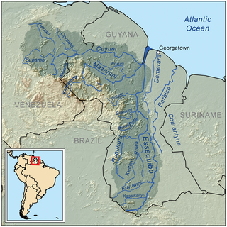
The Rupununi is a region in the south-west of Guyana, bordering the Brazilian Amazon. The Rupununi river, also known by the local indigenous peoples as Raponani, flows through the Rupununi region. The name Rupununi originates from the word rapon in the Makushi language, in which it means the black-bellied whistling duck found along the river.

East Berbice-Corentyne is one of ten regions in Guyana covering the whole of the east of the country. It borders the Atlantic Ocean to the north, the Nickerie District and Sipaliwini District of Suriname to the east, Brazil to the south and the regions of Mahaica-Berbice, Upper Demerara-Berbice, Potaro-Siparuni and Upper Takutu-Upper Essequibo to the west.

Upper Takutu-Upper Esequibo is a region of Guyana. It borders the region of Potaro-Siparuni to the north, the region of East Berbice-Corentyne to the east and Brazil to the south and west. It contains the town of Lethem, and the villages of Aishalton, Nappi and Surama. It is also the largest region of Guyana.

The Takutu River is a river in the Upper Takutu-Upper Essequibo Region of Guyana and Roraima in Brazil. It forms part of the boundary between the two countries. The confluence of the Takutu and Uraricoera Rivers forms the Branco River. The Takutu River's sources almost link with those of the Essequibo River; in the rainy season, flooding links the Takutu to the Rupununi River, a tributary of the Essequibo.
The Siparuni River is a river in the Potaro-Siparuni Region of Guyana. It is a tributary of the Essequibo River. Tributaries of the Siparuni River include the Takutu River, Burro-Burro River, Tipuru River and Levai Creek.

The Iwokrama Forest is a 3,716 square kilometres (1,435 sq mi) nature reserve of central Guyana located in the heart of the Guiana Shield, one of the four last pristine tropical forests in the world. It represents an important transition zone in rainfall, landforms, human histories and biological communities.

The Guyana–Venezuela territorial dispute is an ongoing territorial dispute between Guyana and Venezuela over the Essequibo region, also known as Esequibo or Guayana Esequiba in Spanish, a 159,500 km2 (61,600 sq mi) area west of the Essequibo River. The territory, excluding the Venezuelan-controlled Ankoko Island, is controlled by Guyana as part of six of its regions, based on the 1899 Paris Arbitral Award, but is also claimed by Venezuela as the Guayana Esequiba State. The boundary dispute was inherited from the colonial powers and has persisted following the independence of Venezuela and Guyana.

The following outline is provided as an overview of and topical guide to South America.

Guyana, officially the Co-operative Republic of Guyana, is a country on the northern mainland of South America. Guyana is an indigenous word which means "Land of Many Waters". The capital city is Georgetown. Guyana is bordered by the Atlantic Ocean to the north, Brazil to the south and southwest, Venezuela to the west, and Suriname to the east. With a land area of 215,000 km2 (83,000 sq mi), Guyana is the third-smallest sovereign state by area in mainland South America after Uruguay and Suriname, and is the second-least populous sovereign state in South America after Suriname; it is also one of the least densely populated countries on Earth. It has a wide variety of natural habitats and very high biodiversity.
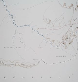
Kutari River, also called Cutari Rivier, Kutari Creek or Cutari Creek, is a small river at the South East of the Tigri Area in the extreme South of Suriname.
The Burro-Burro River is a river of Guyana.
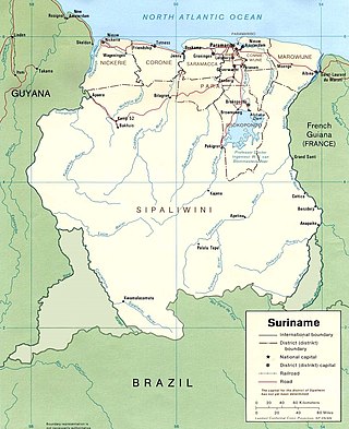
The borders of Suriname consist of land borders with three countries: Guyana, Brazil, and France. The borders with Guyana and France are in dispute, but the border with Brazil has been uncontroversial since 1906.
Surama is an Amerindian village in the North Rupununi area and the Upper Takutu-Upper Essequibo Region of Guyana, with a population of 274 people as of 2012.

Indigenous peoples in Suriname, Native Surinamese, or Amerindian Surinamese, are Surinamese people who are of indigenous ancestry. They comprise approximately 3.5% of Suriname's population of 612,985.
Guyana occurs within the northern part of the Guiana Shield. The Guiana Shield forms the northern part of the Amazonian Craton, the core of the South American continent.
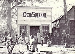
Manchester was a mining town in the Los Burros Mining District in the southern Big Sur region of Monterey County, California from about 1875 to 1895. The town was reached by a 20 miles (32 km) road from King City to Jolon. From Jolon travelers could ride or take a stage or wagon to the Wagon Caves, followed by a difficult 14 miles (23 km) trail over the steep Santa Lucia Mountains to the site, about 4 miles (6.4 km) inland of Cape San Martin. Prospecting began in the area in the 1850s.
Karasabai is an indigenous village of Macushi Amerindians in the Upper Takutu-Upper Essequibo Region of Guyana. It is located in the South Pakaraima Mountains, and near the Ireng River which flows south to the Amazon River.
