Guayana Region, Venezuela

Last updated
Guayana Region
Región Guayana
Guayana Region in Venezuela.svg
Formation11 June 1969
Area
  Total458,344 km2 (176,968 sq mi)
Population
  Total1,383,297

The Guayana Region is an administrative region of eastern Venezuela.

Contents

History

Tepuy Autana (Kuaymayojo) in Amazonas, Venezuela Tepuy Autana (Kuaymayojo).jpg
Tepuy Autana (Kuaymayojo) in Amazonas, Venezuela
Canaima Lagoon, Guayana Region, Venezuela Atardecer en la Laguna de Canaima (Sector Occidental).JPG
Canaima Lagoon, Guayana Region, Venezuela
Relief map of Venezuela Venezuela relief location map (+claimed).jpg
Relief map of Venezuela

In the 1970s, after the process of forming the Political-Administrative Regions through CORDIPLAN  [ es ] in the government of Rafael Caldera, the Region of Guyana was formed. It was originally composed of Bolívar State and Delta Amacuro State (at that time it had the status of a Federal Territory). The Amazonas State (called Territorio Federal Amazonas) was the only one that made up the so-called Southern Region (Región Sur). In the following decade, following a legal reform, the state of Amazonas was integrated into this region.

Geography

The region has a population of 1,383,297 inhabitants and a territory of 458,344 km2 (176,968 sq mi), slightly over half the area of the whole country.

During the colonial period until the early 18th century, it was known as Spanish Guiana. It borders the independent nations of Guyana (formerly British Guiana) and Brazil.

Geologically it is part of the Guiana Shield, and is also known as the Venezuelan Guayana. [1] The higher elevation Guayana Highlands and its tepuis (mesas) are in the southwestern section.

Political division

Almost the entirety of this immense region is formed by the states of Amazonas and Bolívar, but we must also consider that the entire southern part of the state of Delta Amacuro corresponds to it.

The main cities of the region are Ciudad Guayana, with more than half a million inhabitants and which is made up of Puerto Ordaz and San Félix; the capital of the State of Bolívar, Ciudad Bolívar, Upata, Caicara del Orinoco, Tumeremo, Guasipati, El Callao, El Manteco, Santa Elena de Uairén, all of these in the State of Bolívar and the capital of Amazonas, Puerto Ayacucho. As far as the state of Delta Amacuro, south of the Orinoco, is concerned, there is no population with more than a thousand inhabitants. But there are small towns like El Triunfo, which is 22 km from Ciudad Guayana, and Piacoa a little over 50 km.

The region comprises, according to Venezuelan law, four of the federal States of Venezuela:

Some of the biggest towns and cities include:

Ciudad Bolivar (Bolivar City), Bolivar State, Guayana Region PUERTO Y CATEDRAL C BOLIVAR.JPG
Ciudad Bolívar (Bolívar City), Bolívar State, Guayana Region

Relief

The relief of the Guayana Region is very varied, including plains and savannahs, with heights ranging from 100 to 500 m. The Gran Sabana is a plain with an average altitude of 1,000 m. and is home to the tepuis, extraordinary geological formations, including the 2.810 m Roraima, the Auyantepui, with the highest waterfall in the world; the Salto Ángel, with its almost one thousand meters of vertical drop; and several sierras or mountain ranges which reach considerable peaks and whose culminating point is the Marahuaca hill with its 3,840 m. Everything about the relief can be seen in greater detail in each of the states that make up Guyana and will be described separately in each of them.

Weather

Depending on the altitude, a diversity of climates can be found, from torrid (hot) on the banks of the Orinoco, through a very mild (temperate) climate in La Gran Sabana, to the cool climate of the peaks of the tepuy es and the region's mountain ranges.

Vegetation

Due to its immense extension, the vegetation of the Guiana Region, with the exception of that generated by the eternal snows of the Andes and the dunes of Falcon, is a sample of all the vegetation that covers the Venezuelan soil, effectively through its wide geography, There is halophytic vegetation, which is typical of mangroves, herbaceous vegetation of the savannahs, xerophytic vegetation which is that of the thorn or xerophytic forest, the hydrophilic vegetation of the forests, and that of the cloud forest on the mountain slopes.

Geology

The region of the Guiana Shield is mainly composed of mountainous formations called Tepuy (plural "tepuis"), which can be traced back more than 2000 million years, and are the oldest formations on the planet.

Kukenan Tepuy at sunset Kukenan Tepuy at Sunset.jpg
Kukenan Tepuy at sunset

Among these formations are the Roraima (2810 msnm), the Kukenán (2680 masl) and the Auyantepui (2535 masl) all within El Parque Nacional De Canaima.

Economy

The gold mine at El Callao (Venezuela), started in 1871, was for a time one of the richest in the world, and the goldfields as a whole saw over a million ounces exported between 1860 and 1883. The gold mining was dominated by immigrants from the British Isles and the British West Indies, giving an appearance of almost creating an English colony on Venezuelan territory.

In 1926, a Venezuelan mining inspector found one of the richest iron ore deposits near the Orinoco delta, south of the city of San Felix on a mountain named El Florero. Full-scale mining of the ore deposits began after World War II, by a conglomerate of Venezuelan firms and US steel companies. At the start in the early 1950s, about 10,000 tons of ore-bearing soil was mined per day. [2]

Los Pijiguaos, bauxite deposit and associated mining development, on the Pijiguaos Plateau, in western Bolívar state, Venezuela. Discovered in 1974, this large, high-quality, laterite-type deposit underlies some 2,000 square miles (5,200 km2) and is located approximately 25 miles (40 km) east of the Orinoco River.

In the area of the Macizo Guayanés, many resources are extracted, which come mainly from the mines and deposits of the Cuadrilátero Minero Bolivar.

The region also has vast forest reserves, and extensive rivers, as Orinoco and Caroni, that provide much of the electricity consumed in the country, as well as great tourism potential with places like Canaima National Park which includes the highest waterfall in the world (Angel Falls) and is rich in heavy oil that is concentrated in the northern area of Bolivar State.

In the region of Guayana, due to its great hydroelectric potential, it has mining wealth: that is to say, abundance of iron ore and bauxite, one of the main heavy industries of Latin America has been installed. Indeed, Siderúrgica del Orinoco, is a factory of API tubes and should also be considered the aluminum industry and others derived from the processing of steel and aluminum. Other important minerals in the region are nickel, manganese, uranium, coltan and mercury. There are also significant amounts of precious metals, (gold and platinum and diamonds).

See also

Related Research Articles

<span class="mw-page-title-main">Geography of Venezuela</span> Geography of Venezuela

Venezuela is a country in South America, bordering the Caribbean Sea and the North Atlantic Ocean, between Colombia and Guyana. It is situated on major sea and air routes linking North and South America. Located at the northernmost end of South America, Venezuela has a total area of 912,050 km2 (352,140 sq mi) and a land area of 882,050 km2 (340,560 sq mi). It is the 32nd largest country and is slightly smaller than Egypt, or half the size of Mexico. Shaped roughly like an inverted triangle, the country has a 2,800 km (1,700 mi) long coastline. It is bound on the north by the Caribbean Sea and the Atlantic Ocean, on the east by Guyana, on the south by Brazil, and on the west by Colombia. It has the 55th largest Exclusive Economic Zone of 471,507 km2 (182,050 sq mi). Its maritime territory borders Trinidad and Tobago, Dominica, the Dominican Republic, Grenada, St. Kitts and Nevis, St. Vincent and the Grenadines, France, the United Kingdom, the Netherlands, and the United States. Venezuela also claims the region of Guayana Esequiba, currently under the control of Guyana.

<span class="mw-page-title-main">Orinoco</span> River in Venezuela and Colombia

The Orinoco is one of the longest rivers in South America at 2,250 kilometres (1,400 mi). Its drainage basin, sometimes known as the Orinoquia, covers 989,000 km2 (382,000 sq mi), with 76.3 percent of it in Venezuela and the remainder in Colombia. It is the fourth largest river in the world by discharge volume of water. The Orinoco River and its tributaries are the major transportation system for eastern and interior Venezuela and the Llanos of Colombia. The environment and wildlife in the Orinoco's basin are extremely diverse.

<span class="mw-page-title-main">Guiana Shield</span> Precambrian geological formation in northeast South America

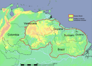
The Guiana Shield is one of the three cratons of the South American Plate. It is a 1.7 billion-year-old Precambrian geological formation in northeast South America that forms a portion of the northern coast. The higher elevations on the shield are called the Guiana Highlands, which is where the table-like mountains called tepuis are found. The Guiana Highlands are also the source of some of the world's most well-known waterfalls such as Angel Falls, Kaieteur Falls and Cuquenan Falls.

<span class="mw-page-title-main">Angel Falls</span> Tallest single drop waterfall in the world, Venezuela

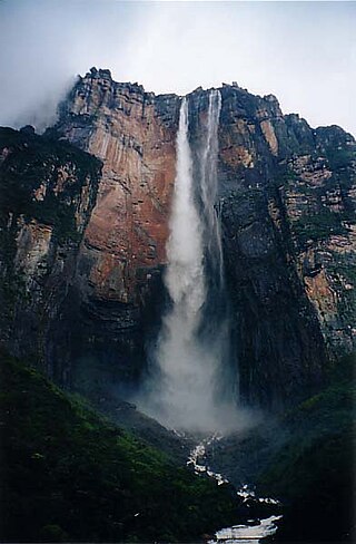
Kerepakupai merú. Receiving its name of after the American adventurer James Angel landed his plane there in 1937 Angel Falls is a waterfall in Venezuela. It is the world's tallest uninterrupted waterfall, with a height of 979 metres (3,212 ft), and a plunge of 807 m (2,648 ft). The waterfall drops over the edge of the Auyán-tepui mountain in the Canaima National Park, a UNESCO World Heritage Site in the Gran Sabana region of Bolívar State. The height figure, 979 m (3,212 ft), mostly consists of the main plunge but also includes about 400 metres (1,300 ft) of sloped cascade and rapids below the drop and a 30-metre-high (100 ft) plunge downstream of the talus rapids.

<span class="mw-page-title-main">Tepui</span> Table-top mountain or mesa in the Guiana Highlands of South America

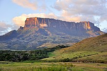
A tepui, or tepuy, is a table-top mountain or mesa found in South America, especially in Venezuela and western Guyana. The word tepui means "house of the gods" in the native tongue of the Pemon, the indigenous people who inhabit the Gran Sabana.

<span class="mw-page-title-main">Auyán-tepui</span> Tepui in Venezuela

Auyán-tepui, also spelt Ayan, is a tepui in Bolívar state, Venezuela. It is the most visited and one of the largest tepuis in the Guiana Highlands, with a summit area of 666.9 km2 (257.5 sq mi) and an estimated slope area of 715 km2 (276 sq mi).

<span class="mw-page-title-main">Bolívar (state)</span> State of Venezuela

Bolívar is one of the 23 states of Venezuela. The state capital city is Ciudad Bolívar, but the largest city is Ciudad Guayana. Bolívar State covers a total surface area of 242,801 km2 (93,746 sq mi) and as of the 2011 census, had a population of 1,410,964. The state contains Angel Falls.

<span class="mw-page-title-main">Delta Amacuro</span> State of Venezuela

Delta Amacuro State is one of the 23 states of Venezuela, and is the location of the Orinoco Delta. The Paria Gulf and the Atlantic Ocean are found to the north, Bolívar State is found to the south, the Atlantic Ocean and Guyana are found to the east, and Monagas State is found to the west. The state capital city is Tucupita.

<span class="mw-page-title-main">Mount Roraima</span> Mountain in Brazil, Guyana and Venezuela

Mount Roraima is the highest of the Pacaraima chain of tepuis or plateaux in South America. It is located at the junction of Brazil, Guyana and Venezuela. A characteristic large flat-topped mountain surrounded by cliffs 400–1,000 m (1,300–3,300 ft) high. The highest point of Mount Roraima is located on the southern edge of the cliff at an altitude of 2,810 m (9,220 ft) in Venezuela, and another protrusion at an altitude of 2,772 m (9,094 ft) at the junction of the three countries in the north of the plateau is the highest point in Guyana. The name Mount Roraima came from the native Pemon people. Roroi in the Pemon language means "blue-green", and ma means "great".

<span class="mw-page-title-main">Pemon</span> Indigenous people living in areas of Venezuela, Brazil, and Guyana

The Pemon or Pemón (Pemong) are indigenous people living in areas of Venezuela, Brazil, and Guyana. The Pemon people are divided into many dialects and traditions, which are; Arekuna, Kamarakoto, and Taurepang.

<span class="mw-page-title-main">Ciudad Guayana</span> Place in Bolívar, Venezuela

Ciudad Guayana is a city in Bolívar State, Venezuela. It stretches 40 kilometers along the south bank of the Orinoco river, at the point where it is joined by its main tributary, the Caroní river. The Caroní flows through the city from south to north, dividing it into its predominant halves — the old town of San Félix, to the east, and the newer area of Puerto Ordaz, to the west.

<span class="mw-page-title-main">Canaima National Park</span> National park in Venezuela

Canaima National Park Guyana is a 30,000 km2 (12,000 sq mi) park in south-eastern Venezuela that roughly occupies the same area as the Gran Sabana region. It is located in Bolívar State, reaching the borders with Brazil and Guyana. The park was named a World Heritage Site by UNESCO.

La Gran Sabana is a region in southeastern Venezuela, part of the Guianan savanna ecoregion.

<span class="mw-page-title-main">Climate of Venezuela</span>

The Climate of Venezuela is characterized for being tropical and megathermal as a result of its geographical location near the Equator, but because of the topography and the dominant wind direction, several climatic types occur which can be the same as found in temperate latitudes, and even polar regions. Latitude exerts little influence on the Venezuelan While the coastal cities of Maracaibo, Barcelona, Porlamar and Maiquetia can get extremely hot, cities located at valleys such as Mérida, Caracas, Los Teques and San Cristobal have cooler climates, and the highest towns of Mucuchies and Apartaderos have cold (tundra) climates.

<span class="mw-page-title-main">Yuruaní-tepui</span>

Yuruaní-tepui, also known by the Pemón name Iwalkarima, Iwalecalima or Iwarkárima, is a tepui of the Eastern Tepuis chain primarily situated in Venezuela, while part of the eastern ridge stretches across the border with Guyana and into the Guayana Esequiba region. It has an elevation of around 2,400 metres (7,900 ft), the high plateau being located entirely within Venezuela, and a summit area of 4.38 km2 (1.69 sq mi). It lies just east of the much smaller Wadakapiapué-tepui. This Tepui is not located in the Canaima National Park unlike most other Tepuis in the area.

The Sierra de Lema is an upland mountain range area with tepuis, located in Bolívar state of southeastern Venezuela.

Solanum tepuiense is a plant species native to Venezuela. It is known from one collection, from a low-elevation sandstone flat-topped mountain named Sororopán-Tepuí, near the Gran Sabana Region in the State of Bolívar in the eastern part of the country.

<span class="mw-page-title-main">Tourism in Venezuela</span>

Tourism in Venezuela has been developed considerably for decades, particularly because of its geographical position, the variety of landscapes, the richness of plants and wildlife, the artistic expressions and the privileged tropical climate of the country, which affords each region throughout the year. Since 2013 the country is having a very severe economic and political crisis affecting tourism all over the country.

<span class="mw-page-title-main">Guayana natural region</span> Geographic region of Venezuela

The Guayana natural region, also simply known as Guayana in Venezuela, is a large massif of approximately 441,726 km2 (170,551 sq mi) area, equivalent to 48.2% of the total continental territory of the country.

<span class="mw-page-title-main">Formaciones de Tepuyes Natural Monument</span>

The Formaciones de Tepuyes Natural Monument also known as tepui Also Formaciones de Tepuyes Is a protected natural space since 1991, located in Venezuela more specifically in the states of Amazonas and Bolívar. Should not be confused with the Canaima national park that contains part of the tepuyes.

References

  1. Berry, P.E., B.K. Holst & K. Yatskievych (eds.) (1995). Flora of the Venezuelan Guayana. Volume 1. Introduction. Missouri Botanical Garden Press, St. Louis.
  2. Magazines, Hearst (July 1949). Popular Mechanics. Hearst Magazines.