
Guinea-Bissau, officially the Republic of Guinea-Bissau, is a country in West Africa that covers 36,125 square kilometres (13,948 sq mi) with an estimated population of 2,026,778. It borders Senegal to its north and Guinea to its southeast.
The region now known as Guinea-Bissau has been inhabited for thousands of years. In the 13th century, it became a province of the Mali Empire that later became independent as the Empire of Kaabu. The region was claimed by Portugal beginning in the 1450s. During most of this period, Portuguese control of the region was limited to a number of forts along the coast. Portugal gained full control of the mainland after the pacification campaigns of 1912–15. The offshore Bijago islands were not colonised until 1936. After independence in 1974, the country was controlled by a single-party system until 1991. The introduction of multi-party politics in 1991, brought the first multi-party elections in 1994. A civil war broke out from 1998 to 1999.

The economy of Guinea-Bissau comprises a mixture of state-owned and private companies. Guinea-Bissau is among the world's least developed nations and one of the 10 poorest countries in the world, and depends mainly on agriculture and fishing. Cashew crops have increased remarkably in recent years, and the country ranked ninth in cashew production for the year 2019.

Bissau is the capital and largest city of Guinea-Bissau. As of 2015, it had a population of 492,004. Bissau is located on the Geba River estuary, off the Atlantic Ocean, and is Guinea-Bissau's largest city, major port, its administrative and military centre.

Portuguese Guinea, called the Overseas Province of Guinea from 1951 until 1972 and then State of Guinea from 1972 until 1974, was a West African colony of Portugal from 1588 until 10 September 1974, when it gained independence as Guinea-Bissau.
Articles related to Guinea-Bissau include:

Buba is the largest city in southern Guinea-Bissau and the capital of the Quinara region. Itlies on the extreme end of the Rio Grande de Buba, near the Contanhez National Park, and has a population 6,815.

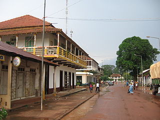
Cacheu is a town in northwestern Guinea-Bissau lying on the Cacheu River, capital of the eponymous region. Its population was estimated to be 9,849 as of 2008.
Gabu is the largest town in eastern Guinea-Bissau and capital of the Gabu Region.
The lançados were settlers and adventurers of Portuguese origin in Senegambia, Cabo Verde, Guinea, Sierra Leone, and other areas on the coast of West Africa. Many were Jews—often New Christians—escaping persecution from the Portuguese Inquisition. Lançados often took African wives from local ruling families, securing protection and advantageous trading ties. They established clandestine trading networks in weaponry, spices, and slaves. This black market angered the Portuguese Crown by disrupting its ability to collect taxes.

The geography of North Africa has been reasonably well known among Europeans since classical antiquity in Greco-Roman geography. Northwest Africa was known as either Libya or Africa, while Egypt was considered part of Asia.
The Forte de São João Baptista de Ajudá is a small restored fort in Ouidah, Benin. Built in 1721, it was the last of three European forts built in that town to tap the slave trade of the Slave Coast. Following the legal abolition of the slave trade early in the 19th century, the Portuguese fort lay abandoned most of the time until it was permanently reoccupied in 1865.

The Kingdom of Loango was a pre-colonial African state, during approximately the 16th to 19th centuries in what is now the western part of the Republic of the Congo, Southern Gabon and Cabinda. Situated to the north of the more powerful Kingdom of Kongo, at its height in the 17th century Loango influence extended from Cape St Catherine in the north to almost the mouth of the Congo River.
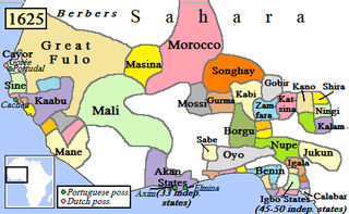
Kaabu (1537–1867), also written Gabu, Ngabou, and N'Gabu, was a federation of Mandinka kingdoms in the Senegambia region centered within modern northeastern Guinea-Bissau, large parts of today's Gambia, and extending into Koussanar, Koumpentoum, and the Casamance in Senegal.

Rivières du Sud was a French colonial division in West Africa, roughly corresponding to modern coastal sections of Guinea. While the designation was used from the 18th to 20th century, the administrative division only existed from 1882-1891.
Papels, also known as Moium, Oium, Papei, Pepel or Pelels, are an ethnic group primarily located in Guinea-Bissau, though are also found in Casamance (Senegal) and Guinea. Their population in Guinea-Bissau is about 183,000, with 9,000 living outside of the country. They traditionally engaged in hunting and agriculture.

The Biafada people is an ethnic group of Guinea-Bissau, Senegal and Gambia. This group is often considered as a subgroup of the Tenda people. They are also known as Biafara, Beafada, Biafar, Bidyola, Dfola, Dyola, Fada, and Yola.
Fort São José of Amura, also known locally as Amura Fort, is a fortification located in the city of Bissau, region of Bissau, capital of Guinea-Bissau, in West Africa.
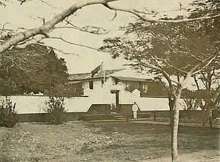
British Guinea or Colony of Bolama and Bolama River, was a colony of the United Kingdom in West Africa. Its capital was in the city of Bolama.
