The Global 200 is the list of ecoregions identified by the World Wide Fund for Nature (WWF), the global conservation organization, as priorities for conservation. According to WWF, an ecoregion is defined as a "relatively large unit of land or water containing a characteristic set of natural communities that share a large majority of their species dynamics, and environmental conditions". For example, based on their levels of endemism, Madagascar gets multiple listings, ancient Lake Baikal gets one, and the North American Great Lakes get none.
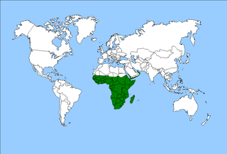
The Afrotropical realm is one of the Earth's eight biogeographic realms. It includes Sub-Saharan Africa, the southern Arabian Peninsula, the island of Madagascar, and the islands of the western Indian Ocean. It was formerly known as the Ethiopian Zone or Ethiopian Region.

Tropical and subtropical moist broadleaf forests (TSMF), also known as tropical moist forest, is a subtropical and tropical forest habitat type defined by the World Wide Fund for Nature.
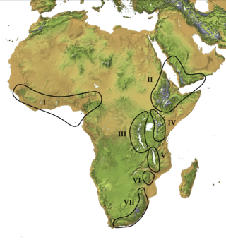
In West Africa, the Dahomey Gap refers to the portion of the Guinean forest-savanna mosaic that extends all the way to the coast in Benin, Togo, and Ghana, thus separating the forest zone that covers much of the south of the region into two separate parts. The forest region west of the gap is called the Upper Guinean forests or Guinean forest zone, and the portion east of the gap is called the Lower Guinean forests, Lower Guinean-Congolian forests, or Congolian Forest Zone.

The Guinean forests of West Africa is a biodiversity hotspot designated by Conservation International, which includes the belt of tropical moist broadleaf forests along the coast of West Africa, running from Sierra Leone and Guinea in the west to the Sanaga River of Cameroon in the east. The Dahomey Gap, a region of savanna and dry forest in Togo and Benin, divides the Guinean forests into the Upper Guinean forests and Lower Guinean forests.

The Upper Guinean forests is a tropical seasonal forest region of West Africa. The Upper Guinean forests extend from Guinea and Sierra Leone in the west through Liberia, Côte d'Ivoire and Ghana to Togo in the east, and a few hundred kilometers inland from the Atlantic coast. A few enclaves of montane forest lie further inland in the mountains of central Guinea and central Togo and Benin.
The Lower Guinean forests also known as the Lower Guinean-Congolian forests, are a region of coastal tropical moist broadleaf forest in West Africa, extending along the eastern coast of the Gulf of Guinea from eastern Benin through Nigeria and Cameroon.

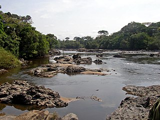
The Congolian rainforests are a broad belt of lowland tropical moist broadleaf forests which extend across the basin of the Congo River and its tributaries in Central Africa.

Forest–savanna mosaic is a transitory ecotone between the tropical moist broadleaf forests of Equatorial Africa and the drier savannas and open woodlands to the north and south of the forest belt. The forest–savanna mosaic consists of drier forests, often gallery forest, interspersed with savannas and open grasslands.
The Afromontane regions are subregions of the Afrotropical realm, one of the Earth's eight biogeographic realms, covering the plant and animal species found in the mountains of Africa and the southern Arabian Peninsula. The Afromontane regions of Africa are discontinuous, separated from each other by lower-lying areas, and are sometimes referred to as the Afromontane archipelago, as their distribution is analogous to a series of sky islands.

The Northern Congolian forest–savanna mosaic is a forest and savanna ecoregion of central Africa. It extends east and west across central Africa, covering parts of Cameroon, Central African Republic, Democratic Republic of the Congo, South Sudan, and Uganda. It is part of the belt of transitional forest-savanna mosaic that lie between Africa's moist equatorial Guineo-Congolian forests and the tropical dry forests, savannas, and grasslands to the north and south.

The Atlantic Equatorial coastal forests, also known as the Congolian coastal forests, are a tropical moist broadleaf forest ecoregion of Central Africa, covering hills, plains, and mountains of the Atlantic coast of Cameroon, Equatorial Guinea, Gabon, Republic of the Congo, Angola, and Democratic Republic of the Congo.

The Rumpi Hills are an undulating mountain range with its highest peak, Mount Rata about 1,800 m (5,900 ft) located between the villages of Dikome Balue and Mofako Balue, Ndian division in the Southwest region of Cameroon. The hills are situated at 4°50’N 9°07’E, cutting across four local councils, with the eastern slopes in Dikome Balue, southern slopes in Ekondo Titi, western slopes in Mundemba, and northern slopes in Toko local councils respectively. These hills are located about 80 km (50 mi) north of Mount Cameroon; about 50 km (31 mi) west of the Bakossi Mountains and some 15 km (9.3 mi) southeast of the Korup National Park.

Northern Zanzibar–Inhambane coastal forest mosaic, also known as the Northern Swahili coastal forests and woodlands, is a tropical moist broadleaf forest ecoregion of coastal East Africa. The ecoregion includes a variety of habitats, including forest, savanna and swamps.
Moyencharia winteri is a moth of the family Cossidae. It is found in south-western Sudan and the north-eastern part of the Democratic Republic of the Congo. The range probably extends into the Central African Republic. The habitat consists of a mosaic of wooded farmland, swampy sites, savanna with drier peripheral semi-evergreen Guineo-Congolian rain forests and riparian forests at low elevations.

The southern Congolian forest–savanna mosaic is an ecoregion that covers a large area of the southern Democratic Republic of the Congo and northeastern Angola. Its rich blend of habitats provides key insights into the biogeography of central Africa with the extensive climatic variation that it has been experiencing for the last 10 million years. The human population is not high.
The Northeastern Congolian lowland forests is a tropical moist broadleaf forest ecoregion that spans the Democratic Republic of the Congo and the Central African Republic.

The Northwestern Congolian lowland forests is a tropical moist broadleaf forest ecoregion that spans Cameroon, Gabon, the Republic of Congo, the Central African Republic and a minuscule part of the Democratic Republic of the Congo. It forms part of the larger Congolian rainforests region in Central Africa. The region is noteworthy for very high levels of species richness and endemism. It is home to a core population of the critically endangered Western lowland gorilla. There are also large populations of forest elephants.

The Victoria Basin forest–grassland mosaic is an ecoregion that lies mostly in Uganda and extends into neighboring countries. The ecoregion is centered north and west of Lake Victoria, with an outlier on the border of Ethiopia and South Sudan.
The Zambezian region is a large biogeographical region in Africa. The Zambezian region includes woodlands, savannas, grasslands, and thickets, extending from east to west in a broad belt across the continent. The Zambezian region lies south of the rainforests of the Guineo-Congolian region. The Zambezian region is bounded by deserts and xeric shrublands on the southwest, the Highveld grasslands of South Africa to the south, and the subtropical Maputaland forests on the southeast.


