
Franklin is a town in and the county seat of Macon County, North Carolina, United States. It is situated within the Nantahala National Forest. The population was reported to be 4,175 in the 2020 census, an increase from the total of 3,845 tabulated in 2010.

The Rotten Calder is a river to the east of East Kilbride, South Lanarkshire, Scotland and along with the Rotten Burn it forms the southern and western boundaries of Blantyre.

Afon Mellte or the River Mellte is a river in south Wales. It is formed by the confluence of the Afon Llia and the Afon Dringarth. It then flows south through the village of Ystradfellte to Pontneddfechan where it joins with the Nedd Fechan to become the River Neath. The river derives its name from 'mellt' - the Welsh word for 'lightning' - after its tendency to rise and fall rapidly in response to heavy rainfall.

The Afon Rheidol is a river in Ceredigion, Wales, 19 miles (31 km) in length. The source is Plynlimon. Receiving an average annual rainfall of 40 inches (1.02 m), Plynlimon is also the source of both the Wye and the Severn.
Dalry is a small town in the Garnock Valley in Ayrshire, Scotland. Drakemyre is a northern suburb.

Glen Affric is a glen south-west of the village of Cannich in the Highland region of Scotland, some 15 miles west of Loch Ness. The River Affric runs along its length, passing through Loch Affric and Loch Beinn a' Mheadhoin. A minor public road reaches as far as the end of Loch Beinn a' Mheadhoin, but beyond that point only rough tracks and footpaths continue along the glen.

Meikle Auchengree is a hamlet near Kilbirnie and Longbar in North Ayrshire, Scotland.
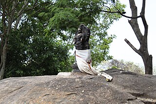
Kumbakkarai Falls are lesser known falls in the foothills of the Kodaikanal Hills. They are located at 10°10′48″N77°31′50″E in Theni district, 9 kilometers (5.6 mi) from Periyakulam. Kumbakkarai Falls are located along the Kodai-Vellagavi-Periyakulam footpath.
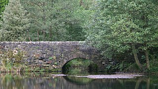
Bentley Brook is a stream in Derbyshire, England. It rises on Matlock Moor, flowing south through Cuckoostone Dale, under the A632, into Lumsdale, gathering the valley's waters—notably from Knabhall Brook, out of Tansley, itself dammed and supporting large mills. In Lumsdale it enters a now disused mill pond or reservoir, then flows over a waterfall in the course of passing several historical mill ruins. Finally, it runs through control gates into the outside bend of a tight oxbow of the River Derwent, just beyond Hall Leys Park in Matlock. Although only about five miles in length, Bentley Brook is classed as a 'main river' by the Environment Agency.

ʻŌpaekaʻa Falls is a waterfall located on the ʻŌpaekaʻa Stream in Wailua River State Park on the eastern side of the Hawaiian island of Kauai. It is a 151-foot (46 m) waterfall that flows over basalt from volcanic eruptions millions of years ago. Below the ridge down into the ravine through which the water falls can be seen the vertical dikes of basalt that cut through the horizontal Koloa lava flows. The name "ʻŌpaekaʻa" means rolling shrimp, "ʻopae" being Hawaiian for "shrimp," and "kaʻa" for "rolling". The name dates back to days when the native freshwater shrimp Atyoida bisulcata were plentiful in the stream and were seen rolling and tumbling down the falls and into the churning waters at the fall's base.
The Bonnington Pavilion or Hall of Mirrors, now a ruin, is situated in the grounds of the old estate of Bonnington, near New Lanark, overlooking Corra Linn falls on the River Clyde in Lanarkshire, Scotland. Alternative names are the Corra Linn Pavilion and the Falls of Clyde summerhouse. It is said to have been the first Camera obscura built in Scotland. The name comes from the Gaelic 'currach', a marshy place. A legend gives 'Cora' as a daughter of King Malcolm II, who leapt to her death here whilst trying to escape imagined danger.
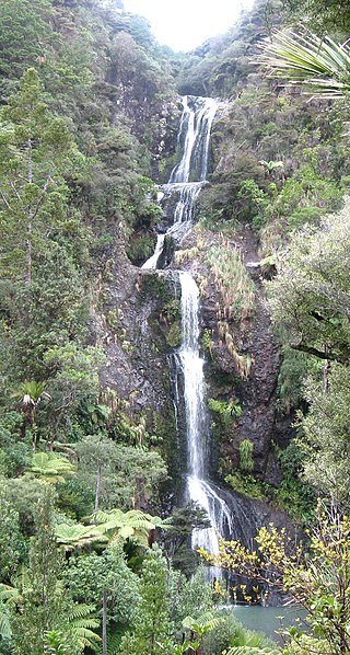
Kitekite Falls is a scenic 3-tiered waterfall near Auckland, New Zealand. The falls drop a total of 40 metres (130 ft). From the lookout on Kitekite track the falls appear even higher because there is white water running over rocks into a small pool from the upper swimming hole, then falling down into a large pool, then falling to a small pool before beginning an almost vertical descent in the final 3-tiers, making the total height closer to 80 metres (260 ft). They are located on the Glen Esk stream near Piha Beach.

The Grey Mare's Tail is a waterfall on the very edge of the Snowdonia National Park near Gwydir Castle in the county of Conwy, north Wales. It lies just off the B5106 road between the town of Llanrwst and the large village of Trefriw. The Welsh name, Rhaeadr y Parc Mawr, derives from the fact that the falls are fed by a large stream that has its source in the Gwydir Forest, and flows through the old Parc Mine, about a mile to the southeast. The name 'Grey Mare's Tail' was given to it by Lady Willoughby of Gwydir Castle, possibly "in compliment to Lord Byron and the Staubbach"

Tomich is a Victorian model conservation village situated in the Scottish Highlands at the western end of Strathglass, approximately 30 miles from Inverness.

Coelbren is a small rural village within the community of Tawe Uchaf in southernmost Powys, Wales. It lies on the very northern edge of the South Wales Coalfield some six miles north-east of Ystradgynlais and just outside the southern boundary of the Brecon Beacons National Park. It is known for Henrhyd Falls, a 27m high waterfall which serves as a National Trust-managed visitor attraction on the Nant Llech. To the east of the village flows the Afon Pyrddin which plunges over two more spectacular falls.

The Hukou Waterfall, is the largest waterfall on the Yellow River, the second largest waterfall in China, and the world's largest yellow waterfall. It is located at the intersection of the provinces of Shanxi and Shaanxi, 165 km (103 mi) to the west of Fenxi County, and 50 km (31 mi) to the east of Yichuan County where the middle reaches of the Yellow River flow through Jinxia Grand Canyon. The width of the waterfall changes with the season, usually 30 metres (98 ft) wide but increasing to 50 m (164 ft) during flood season. It has a height of over 20 m (66 ft). When the Yellow River approaches the Hukou Mountain, blocked by mountains on both sides, its width is abruptly narrowed down to 20–30 m (66–98 ft). The water's velocity increases, and then plunges over a narrow opening on a cliff, forming a waterfall 15 m (49 ft) high and 20 m (66 ft) wide, as if water were pouring down from a huge teapot. Hence it gets the name Hukou Waterfall.

The Poesten Kill is a 26.2-mile-long (42.2 km) creek in upstate New York located entirely in Rensselaer County, which flows westerly from its source at Dyken Pond in the town of Berlin to its mouth at the Hudson River in the city of Troy. The Poesten Creek has historically been used as a source of water for the local inhabitants and farmers. In later times it's become even more important as a source of water power during the Industrial Revolution, during which many mills and factories sprung up along its banks

Plodda Falls is a waterfall, situated 5 km south-west of the village of Tomich, near Glen Affric, in the Highlands of Scotland. The falls are 46 m high, and are on the Allt na Bodachan, near where it flows into the Abhainn Deabhag, which in turn joins with the River Affric to form the River Glass.

