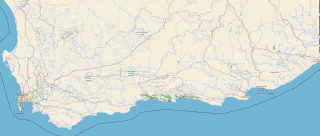
The Garden Route is a 300-kilometre (190 mi) stretch of the south-eastern coast of South Africa which extends from Witsand in the Western Cape to the border of Tsitsikamma Storms River in the Eastern Cape. The name comes from the verdant and ecologically diverse vegetation encountered here and the numerous estuaries and lakes dotted along the coast. It includes towns such as Knysna, Plettenberg Bay, Mossel Bay, Great Brak River, Little Brak River, Wilderness, Sedgefield and Nature's Valley; with George, the Garden Route's largest city and main administrative centre.

The Maputaland-Pondoland bushland and thickets is one of the ecoregions of South Africa. It consists of the montane shrubland biome.

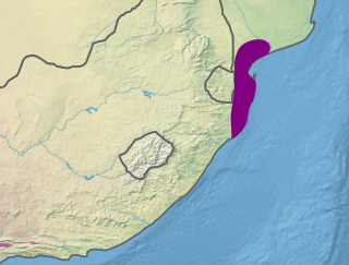
The Kwazulu-Cape coastal forest mosaic is a subtropical moist broadleaf forest ecoregion of South Africa. It covers an area of 17,800 square kilometers (6,900 sq mi) in South Africa's Eastern Cape and KwaZulu-Natal provinces.
The Maputaland coastal forest mosaic is a subtropical moist broadleaf forest ecoregion on the Indian Ocean coast of Southern Africa. It covers an area of 29,961 square kilometres (11,568 sq mi) in southern Mozambique, Eswatini, and the KwaZulu-Natal Province of South Africa. Mozambique's capital Maputo lies within the ecoregion.
Eastern Cape Parks are the national parks, marine protected areas, nature reserves and other nature conservation areas in the Eastern Cape province of South Africa. Eastern Cape Parks and Tourism Agency (ECPTA) is the governmental organisation responsible for maintaining wilderness areas and public nature reserves in the Eastern Cape, based in East London.
East London Coast Nature Reserve is a protected area in Eastern Cape Province, South Africa that is managed by Eastern Cape Parks. It covers an area of 3,424 hectares and incorporates 12 smaller nature reserves and protected areas.

The Garden Route National Park is a national park in the Garden Route region of the Western Cape and Eastern Cape provinces in South Africa. It is a coastal reserve well known for its indigenous forests, dramatic coastline, and the Otter Trail. It was established on 6 March 2009 by amalgamating the existing Tsitsikamma and Wilderness National Parks, the Knysna National Lake Area, and various other areas of state-owned land.
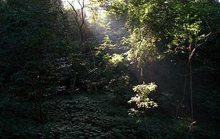
Areas of forest which grow in KwaZulu-Natal, South Africa mostly on south facing slopes in higher rainfall areas, and along the humid coastal areas. Different types of forest can be identified by their species composition which depends mostly on the altitude, latitude and substrate in which they grow. South facing slopes are favourable for the development of forest as they are more shaded, and therefore cooler and retain more moisture than the northern slopes. The extra moisture on the south slopes is not only favoured by forest trees, but also helps to prevent or subdue wildfires. Fires can also be blocked by cliff faces and rocks or boulders on these slopes, and by streams or rivers at the base of the slopes. The coastal regions are conducive to forest formation, because of high rainfall and humidity which are favoured by forest trees and also help to prevent or subdue fires. The rivers of the coastal areas are also broader than further inland, which may often prevent fires from spreading long distances, and fires generally burn uphill and therefore more often away from areas at low altitude.

Kogelberg Nature Reserve is a nature reserve of 3,000 ha comprising the Kogelberg Mountain Range, to the east of Cape Town, South Africa.

The De Hoop Marine Protected Area lies between Arniston and the mouth of the Breede River on the south coast of South Africa adjacent to the De Hoop Nature Reserve. The MPA is 51 kilometres long, and extends 5 nautical miles to sea. The whole MPA is a restricted area and is part of the migratory route and calving area for Southern right whales. The area protects habitats for several economically important inshore reef fish species, and ensures the retention of marine biomass in this part of the coast. The limestone coastline is includes archaeological sites and middens that date back centuries. The MPA is close to the Breede River estuary and, provides protection for species like cob that breed in the estuary and then return to the ocean.
The Dwesa-Cwebe Marine Protected Area is an inshore and offshore conservation region, off the coast of the Dwesa-Cwebe Nature Reserve in the Eastern Cape province, in the territorial waters of South Africa.
The Stilbaai Marine Protected Area is an inshore conservation region in the territorial waters near Stilbaai on the south coast of the Western Cape province of South Africa.
The Bot River Estuary, also known as the Bot River Lagoon, is part of the Bot-Kleinmond Estuarine System in the Overberg region on the Western Cape of South Africa. It became a Ramsar site wetland in 2017.
The Cape Morgan Nature Reserve, part of the greater East London Coast Nature Reserve, is a coastal forest reserve in the Wild Coast region of the Eastern Cape. On its western side lies the Morgan Bay estuary, while it's flanked on the eastern side by the Cwili estuary. Nearby are the of villages of Morgan Bay and Kei Mouth. Southwest of the reserve is the Morgan Bay beach.
The Double Mouth Nature Reserve, part of the greater East London Coast Nature Reserve, is a coastal reserve in the Wild Coast region of the Eastern Cape. Alongside it are the Quko River mouth and the 50-metre high Morgan Bay Cliffs.
The Cape Henderson Nature Reserve, part of the greater East London Coast Nature Reserve, is a coastal forest reserve in the Wild Coast region of the Eastern Cape, South Africa.
The Kwelera Nature Reserve, part of the greater East London Coast Nature Reserve, is a coastal forest reserve in the Wild Coast region of the Eastern Cape, South Africa. Access to the reserve is through the adjacent Kwelera National Botanical Garden, which the reserve now serves as part of the botanical garden. The reserve stretches from the Kwelera River on the eastern side, to the Gqunube River (Gonubie) at the western end of the reserve.
The Nahoon Nature Reserve, part of the greater East London Coast Nature Reserve, is a nature reserve in the Wild Coast region of the Eastern Cape. The reserve is located on the northern bank of the Nahoon River estuary.
