Related Research Articles

The Murrumbidgee River is a major tributary of the Murray River within the Murray–Darling basin and the second longest river in Australia. It flows through the Australian state of New South Wales and the Australian Capital Territory, descending 1,500 metres (4,900 ft) over 1,485 kilometres (923 mi), generally in a west-northwesterly direction from the foot of Peppercorn Hill in the Fiery Range of the Snowy Mountains towards its confluence with the Murray River near Boundary Bend.

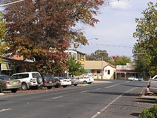
Gundagai is a town in New South Wales, Australia. Although a small town, Gundagai is a popular topic for writers and has become a representative icon of a typical Australian country town. Located along the Murrumbidgee River and Muniong, Honeysuckle, Kimo, Mooney Mooney, Murrumbidgee and Tumut mountain ranges, Gundagai is 390 kilometres (240 mi) south-west of Sydney. Until 2016, Gundagai was the administrative centre of Gundagai Shire local government area. In the 2021 census, the population of Gundagai was 2,057.
Tumbarumba is a town in New South Wales, Australia, about 480 kilometres (300 mi) southwest of the state capital, Sydney. Tumbarumba is located on the periphery of the Riverina and South West Slopes regions at the western edge of the Snowy Mountains. The 2016 census showed the population of the town and surrounding area to be 1,862 people. Locals refer to the town as 'Tumba'.

The Riverina is an agricultural region of south-western New South Wales, Australia. The Riverina is distinguished from other Australian regions by the combination of flat plains, warm to hot climate and an ample supply of water for irrigation. This combination has allowed the Riverina to develop into one of the most productive and agriculturally diverse areas of Australia. Bordered on the south by the state of Victoria and on the east by the Great Dividing Range, the Riverina covers those areas of New South Wales in the Murray and Murrumbidgee drainage zones to their confluence in the west.
Group 9 is a rugby league competition based in Wagga Wagga, New South Wales, Australia, and surrounding areas. The competition is played in six grades, with these being Under 16s, Under 18s, Women's Tackle, Women's League-Tag, Reserve-Grade and First-Grade.

Cootamundra, nicknamed Coota, is a town in the South West Slopes region of New South Wales, Australia and within the Riverina. It is within the Cootamundra-Gundagai Regional Council. At the 2016 Census, Cootamundra had a population of 6,782. It is located on the Olympic Highway at the point where it crosses the Muttama Creek, between Junee and Cowra. Its railway station is on the Main Southern line, part of the Melbourne-to-Sydney line.

Tumut is a town in the Riverina region of New South Wales, Australia, situated on the banks of the Tumut River.

The Division of Riverina is an Australian electoral division in the state of New South Wales.

The South Western Slopes, also known as the South West Slopes, is a region predominantly in New South Wales, Australia. It covers the lower inland slopes of the Great Dividing Range, extending from north of Dunedoo through central NSW and into northeast Victoria, meeting its southwestern end around Beechworth. More than 90% of the region is in the state of New South Wales and it occupies about 10% of that state.

Batlow is a town in the South West Slopes region of New South Wales, Australia, on the edge of the Great Dividing Range, 775 m above sea level.
Cootamundra is an electoral district of the Legislative Assembly in the Australian state of New South Wales.
Wynyard was an electoral district for the Legislative Assembly in the Australian State of New South Wales from 1904 to 1913, including the town of Tumut and named after Wynyard County. It replaced all of the abolished district of Tumut and part of the abolished district of Gundagai. Its only member was Robert Donaldson. The Federal Capital Territory was removed from New South Wales in 1911 and Wynyard was abolished in the 1912 redistribution. Most of the district, including the town of Tumut was absorbed by the district of Yass and the balance was distributed between the surrounding districts of Cootamundra, Wagga Wagga and Albury.

The Tumut and Kunama railway lines are disused railway lines in the south of New South Wales, Australia. The Tumut line was a 104 kilometres (65 mi) long branch of the Main South line, branching southwards from it at Cootamundra and heading to the town of Tumut. The line served the towns of Tumut and Gundagai, where the line crosses the Murrumbidgee River with a large iron girder bridge and wooden viaduct. Villages on the line included Brawlin, Muttama, Coolac and Tumblong.
Australian rivers have been subject to devastating floods in New South Wales, recorded since colonisation. Flooding in New South Wales has predominately been caused by excessive flows into rivers located in New South Wales and, to a lesser extent, excessive flows into rivers located in Queensland and Victoria. Floods can devastate local communities and impact the entire local economy.
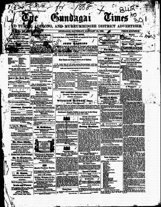
The Gundagai Times and Tumut, Adelong, and Murrumbidgee District Advertiser, often referred to as simply the Gundagai Times, was a newspaper published in Gundagai, New South Wales, Australia from 1868 to 1931. It was a direct successor of The Wynyard Times and Tumut and Adelong Advertiser and The Tumut and Adelong Times, published in Tumut, New South Wales, and was absorbed into The Gundagai Independent in 1931.
The Maher Cup was an Australian rugby league challenge cup contested between towns of the South West Slopes and northern Riverina areas of New South Wales between 1920 and 1971. The main teams involved were Cootamundra, Tumut, Gundagai, Temora, West Wyalong, Young, Harden-Murrumburrah, Junee, Barmedman, Cowra, Grenfell and Boorowa.

The South Eastern Highlands is an interim Australian bioregion in eastern Australia, that spans parts of the states and territories of New South Wales, the Australian Capital Territory, and Victoria. The bioregion comprises 8,375,961 hectares and is approximately 3,860 kilometres (2,400 mi) long. The Australian Alps as well as the South West Slopes bound the region from the south and west; and to the northeast, the Sydney Basin bioregion, as well as the bioregion of the South East Corner, to the east.

Cootamundra–Gundagai Regional Council (CGRC) is a local government area located in the South West Slopes and Riverina regions of New South Wales, Australia. The council was formed on 12 May 2016 through a merger of the Cootamundra and Gundagai shires. Originally named Gundagai Council, the name was changed to Cootamundra–Gundagai Regional Council on 7 September 2016.

The Murrumbidgee River railway bridge is a heritage-listed railway bridge across the Murrumbidgee River located on the Tumut railway line at Gundagai in the Cootamundra-Gundagai Regional Council local government area of New South Wales, Australia. It was built in 1903. It is also known as the Gundagai Rail Bridge over Murrumbidgee River and the Murrumbidgee River Railway Bridge. The property was added to the New South Wales State Heritage Register on 2 April 1999.
The Salt Clay Creek railway disaster was one of Australia's first railway accidents involving multiple fatalities. It occurred on the evening of 25 January 1885, when a mail train from Albury to Sydney failed to negotiate a flooded creek, around 5 km from Cootamundra. Seven people were killed and dozens seriously injured.
References
- 1 2 3 James Halliday. "Gundagai Wine Region". James Halliday’s Wine Atlas of Australia. Retrieved 2 June 2016.
- ↑ "Gundagai". Register of Protected GIs and Other Terms. Wine Australia . Retrieved 2 June 2016.
- ↑ "Gundagai Wine Region". Find a Winery - Australia. Retrieved 2 June 2016.