
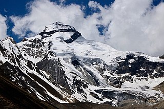
Mount Kailash is a mountain in Ngari Prefecture, Tibet Autonomous Region of China. It lies in the Kailash Range of the Transhimalaya, in the western part of the Tibetan Plateau. The peak of Mount Kailash is located at an elevation of 6,638 m (21,778 ft), north of the western trijunction of the border between China, India and Nepal.

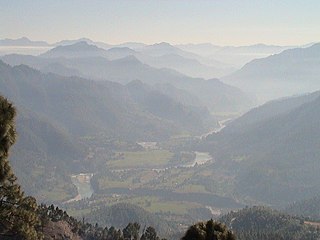
Pithoragarh district is the easternmost district in the state of Uttarakhand. It is located in the Himalayas and has an area of 7,110 km2 (2,750 sq mi) and a population of 483,439. The city of Pithoragarh, located in Saur Valley, is its headquarters. The district is within the Kumaon division of Uttarakhand state. The Tibet plateau is situated to the north and Nepal is to the east. The Kali River which originates from the Kalagiri Mountain flows south, forming the eastern border with Nepal. The Hindu pilgrimage route for Mount Kailash-Lake Manasarovar passes through this district via Lipulekh Pass in the greater Himalayas. The district is administratively divided into six Tehsils: Munsyari; Dharchula; Didihat; Berinag; Gangolihat; and Pithoragarh. Naini Saini Airport is the nearest civil airport, but it does not have a regular scheduled commercial passenger service. The mineral deposits present in the district are magnesium ore, copper ore, limestone, and slate. There are 11 tehsils.

Om Parvat is a mountain located in Pithoragarh district, Uttarakhand, India. Om Parvat's peak elevation is 5,590 m (18,340 ft) above sea level.
Askot or Askote is a small Himalayan town in Pithoragarh district of Uttarakhand in India. It is the part of Kanalichhina development Block and Didihat Tehsil.

Dharchula is a town in Pithoragarh district in the northern state of Uttarakhand, India, situated at an elevation of 940 m above sea level, surrounded by peaks from all sides and Kali river cutting through the middle, dividing the area into two towns on either bank of the river - one in India and the other in Nepal. River Kali originates from Lipulekh Pass and forms the border between India and Nepal. People of the two towns have similar traditions, culture, and lifestyle, and can move across the border without a passport or visa. The area has a mixture of Kumaouni and Rung language, traditions and culture. They move freely across the river as Indians and Nepalis do not need passport or visa to cross the soft border. Dharchula lies about 92 km (57 mi) north of Pithoragarh town, along the route of the Kailash-Mansarovar pilgrimage tour. It lies on the Pithoragagh-Lipulekh Pass Highway (PLPH).
Sangthang is the Himalayan peak in Kumaon Himalayas in Darchula District of Sudurpashchim state of Nepal. But this is in dispute by India.
Sin La is a high Himalayan mountain pass located in the eastern Kumaon in Pithoragarh District of Uttarakhand state in India.

Darma valley is a Himalayan valley situated in the Pithoragarh District of Uttarakhand state of India. This valley is located in the eastern part of Uttarakhand at Kumaon division.
Kuti Valley is a Himalayan valley, an area administered by India and also claimed by Nepal, is situated in the Pithoragarh district of Uttrakhand state of India. It is the last valley before the border with Tibet. It runs along the Limpiyadhura Pass & Adi Kailash in northwest to Gunji in southeast axis, formed by the river Kuti Yankti, which is one of the headwaters of the Kali River. It is reached by the Pithoragagh-Lipulekh Pass Highway (PLPH).

Purang County or Burang County (Tibetan: སྤུ་ཧྲེང་རྫོང; Chinese: 普兰县) is an administrative division of Ngari Prefecture in the Tibet Autonomous Region (TAR) of China. The county seat is Purang Town, known as Taklakot in Nepali. The county covers an area of 12,539 square kilometres (4,841 sq mi), and has a population of 9,657 as of 2010.
Lipulekh La, Lipulekh Pass or Lipu Gad as called in Kumaoni is a Himalayan pass in the border between Kumaon, India and Tibet region held by China. The Old Lipulekh Peak or Old Lipulekh Pass, a Mount Kailash viewing point at 17,500 ft elevation, lies west of Lipulekh Pass. The Lipulekh pass is near the trading town of Taklakot (Purang) in Tibet and used since ancient times by traders, mendicants and pilgrims transiting between India and Tibet. It is also used by pilgrims to Kailas and Manasarovar. It is reached by the Pithoragagh-Lipulekh Pass Highway (PLPH), and a spur from Nabhidhang (Nabidhang) runs along a glaciated river to Om Parvat. The Mount Kailash in Tibet can be viewed from India from the Old Lipulekh Peak which lies northeast of Gunji and the Limpiyadhura Pass which lies northwest of Gunji. The Kali River rises from the Limpiyadhura northeast of Gunji and flows by the KMVN Huts at Nabhidhang, ITBP Base Camp, Indian Forest Police Checkpost to Gunji.
Gori Ganga is a river in the Munsiari tehsil of the Pithoragarh District, part of the state of Uttarakhand in northern India. Its principal source is the Milam Glacier, just northeast of Nanda Devi along with the Glaciers of the Ralam River, and the Pyunshani and Uttari & Dakshini Balati Glaciers that lie on the western face of the Panchachuli Peaks.

Purang or Burang, known as Puhreng in Tibetan, (Nepali:ताक्लाकोट) is a town which serves as the administrative center of Purang County, Ngari Prefecture of the Tibet Autonomous Region (TAR), China. The town lies at an altitude of 3,900m in the valley of the Karnali River. The town spans an area of 3,257.81 square kilometres (1,257.85 sq mi), and has a permanent population 6,047 as of 2010, and a hukou population of 4,477 as of 2018. To the south are Gurla Mandhata and the Abi Gamin ranges. Lake Manasarovar and Mount Kailash are to the north. This region is the mythological and actual river nexus of the Himalaya with sources of the Indus, Ganges and Yarlung Tsangpo/Brahmaputra all within 110 kilometres (70 mi) of Purang.

Johar Valley is a valley located in Pithoragarh district of Uttarakhand, India, along the Gori Ganga river. The valley used to be a major trade route with Tibet. The best known villages in the valley are Martoli and Milam.

The Sharda River is the downstream of Kali River that originates in the northern Uttarakhand state of India in the Great Himalayas on the eastern slopes of Nanda Devi massif, at an elevation of 3,600 m (11,800 ft) in the Pithoragarh district. It then flows between the Nepal and India border. Descending, it enters the Indo-Gangetic Plain at Brahmadev Mandi in Nepal, where it expands above the Sharda Barrage. From that point onward, it is known as the Sharda River. The river proceeds southeastward into India through northern Uttar Pradesh before merging with the Ghaghara River southwest of Bahraich, covering a distance of approximately 300 miles.
Bhotiyas are people of presumed Tibetan heritage that live along the Indo-Tibetan border in the upper reaches of the Great Himalayas, at elevations ranging from 6,500 feet (2,000 m) to 13,000 feet (4,000 m). In Uttarakhand, they inhabit seven river valleys, three in the Garhwal division and four in the Kumaon division. They follow Hinduism with Buddhism and traditionally speak West Himalayish languages related to the old Zhangzhung language. Their main traditional occupation used to be Indo-Tibetan trade, with limited amounts of agriculture and pastoralism. The Ido-Tibetan trade came to a halt following the 1962 Sino-Indian war, and was resumed only in the early 1990s under state-regulated mechanisms. Their major livelihood at present is the collection of medicinal and aromatic plants in the Himalayas. Many have also migrated out of their traditional habitats to towns at lower elevations. The traditional transhumance and pastoralism have also drastically reduced.
The Kalapani territory is an area under Indian administration as part of Pithoragarh district in the Kumaon Division of the Uttarakhand state, but it is also claimed by Nepal since 1997. According to Nepal's claim, it lies in Darchula district, Sudurpashchim Province. The territory represents part of the basin of the Kalapani river, one of the headwaters of the Kali River in the Himalayas at an altitude of 3600–5200 meters. The valley of Kalapani, with the Lipulekh Pass at the top, forms the Indian route to Kailash–Manasarovar, an ancient pilgrimage site. It is also the traditional trading route to Tibet for the Bhotiyas of Kumaon and the Tinkar valley of Nepal.
Adi Kailash, also known as Shiva Kailash, Chota Kailash, Baba Kailash or Jonglingkong Peak, is a mountain located in the Himalayan mountain range in the Pithoragarh district of Uttarakhand, India. It is the second most important peak among the group of five separate peaks in Himalayas in separate locations collectively known as the Panch Kailash or "Five Kailashas", other being Mount Kailash in first place, Shikhar Kailash in third, Kinnaur Kailash in fourth and Manimahesh Kailash in fifth place in terms of importance. Gauri Kund and Parvati Tal glacial lakes are at the base of the Adi Parvat. Adi Kailash & Limpiyadhura Pass are both located northwest of Gunji. The Lipulekh Pass, Old Lipulekh Peak & Om Parvat are located northeast of Gunji. Adi Kailash base camp, near the Hindu Shiva temple on the banks of sacred Jolingkong Lake, is located 17 km northwest of Kuthi (Kuti) village in Kuthi Yankti Valley. The Adi Kailash Yatra Circuit route-1 via Gunji, the eastern-southeastern route, is reached by the Pithoragagh-Lipulekh Pass Highway (PLPH) and its Gunji-Lampiya Dhura Pass Road (GLDPR) paved motorable spur via Kuthi Yankti Valley from Gunji to Adi Kailash. The permits for this route are issued at Dharchula and medical check-up is conducted there. The homestay accommodation is available in the villages along the route in Gunji, Napalachchu, Nabhi, Juli Kong and Kuti. The Adi Kailash Yatra Circuit route-2 via Darma Valley, the western-southwestern route, begins by going up the Darma Valley and then crossing the Sin La pass south of Brahma Parvat to go to Kuthi Yankti Valley to Jolingkong Lake Base Camp. Many travellers who take the route-2, after the Adi Kailash darshan chose to traverse the route-1 in reverse direction till Gunji where they can join the Om Parvat & Mount Kailash-Lake Manasarovar Tibetan pilgrimage route along the Sharda River. Kailash-Mansarovar, Adi Kailash and Om Parvat are sacred to Hindus.

Char Dham National Highway, is an under construction two-lane 889 km long National Highway with a minimum width of 10 metres in the Indian state of Uttarakhand under Char Dham Pariyojana. The under construction highway will complement the under-construction Char Dham Railway by connecting the four holy places in Uttarakhand states namely Badrinath, Kedarnath, Gangotri and Yamunotri. The project includes 889 km national highways which will connect the whole of Uttarakhand state. It will connect Delhi–Dehradun Expressway on its southern end to India-China Border Roads on its northern ends.
Tinkar is a village in the Byans Rural Municipality of Darchula District in the Sudurpashchim province of Nepal. It is named after the Tinkar Khola river, a tributary of the Mahakali River, which it joins near the village of Chhangru.

