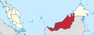
Sarawak is a state of Malaysia. The largest among the 13 states, with an area almost equal to that of Peninsular Malaysia, Sarawak is located in northwest Borneo Island, and is bordered by the Malaysian state of Sabah to the northeast, Kalimantan to the south, and Brunei in the north. The capital city, Kuching, is the largest city in Sarawak, the economic centre of the state, and the seat of the Sarawak state government. Other cities and towns in Sarawak include Miri, Sibu, and Bintulu. As of the 2022, the population of Sarawak was 2.97 million. Sarawak has an equatorial climate with tropical rainforests and abundant animal and plant species. It has several prominent cave systems at Gunung Mulu National Park. Rajang River is the longest river in Malaysia; Bakun Dam, one of the largest dams in Southeast Asia, is located on one of its tributaries, the Balui River. Mount Murud is the highest point in the state. Sarawak is the only state of Malaysia with a Christian majority.

East Malaysia, or the Borneo States, also known as Malaysian Borneo, is the part of Malaysia on and near the island of Borneo, the world's third-largest island. Near the coast of Sabah is a small archipelago called Labuan. East Malaysia lies to the east of Peninsular Malaysia, the part of the country on the Malay Peninsula. The two are separated by the South China Sea.
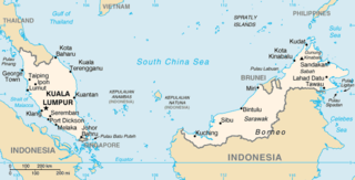
The geography of Malaysia includes both the physical and the human geography of Malaysia, a Southeast Asian country made up of two major landmasses separated by water—Peninsular Malaysia to the west and East Malaysia to the east—and numerous smaller islands that surround those landmasses. Peninsular Malaysia is on the southernmost part of the Malay Peninsula, south of Thailand, north of Singapore and east of the Indonesian island of Sumatra; East Malaysia comprises most of the northern part of Borneo island, and shares land borders with Brunei to the north and Indonesian Borneo to the south.
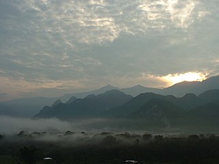
The Gunung Mulu National Park is a national park in Miri Division, Sarawak, Malaysia. It is a UNESCO World Heritage Site that encompasses caves and karst formations in a mountainous equatorial rainforest setting. The park is famous for its caves and the expeditions that have been mounted to explore them and their surrounding rainforest, most notably the Royal Geographical Society Expedition of 1977–1978, which saw over 100 scientists in the field for 15 months. This initiated a series of over 20 expeditions now named the Mulu Caves Project.
Sarawak Chamber is the largest known cave chamber in the world by area and the second largest by volume after the Miao Room in China. It is in Gua Nasib Bagus, which is located in Gunung Mulu National Park, in the Malaysian Territory of Sarawak on the island of Borneo.
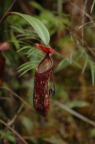
Nepenthes muluensis, or the Mulu pitcher-plant, is a tropical pitcher plant endemic to Borneo. It grows in highland habitats at elevations of 1700 to 2400 m above sea level.
Mount Benarat is a mountain located in Gunung Mulu National Park in Sarawak, Malaysia. Consisting of limestone on the western side which is overlain by gritstone on the eastern side. It contains many caves which have been discovered and explored by British and American cavers. The Benarat 2005 Caving Expedition discovered Moon Cave after climbing 60 m up the cliffs on the southern end of the mountain. On the eastern side, the Headhunter's Trail leads from the Melinau River to the mouth of the Terikan River at the Medalam River. Neighbouring Mount Buda and Mount Api are part of the same formation, separated from Mount Benarat by the Medalam and Melinau Rivers, respectively. It is also home to Benarat Cavern.

Mount Mulu is a sandstone and shale mountain. At 2376 m, it is the second highest mountain in the state of Sarawak, after Mount Murud. It is located within the boundaries of Gunung Mulu National Park, which is named after it.
Shorea atrinervosa is a species of plant in the family Dipterocarpaceae. The species name is derived from Latin and refers to leaf venation which is black in herbarium specimens.
Gua Nasib Bagus or Lubang Nasib Bagus is a cave located in the state of Sarawak in Malaysia. It is one of many caves found within Gunung Mulu National Park, a World Heritage Site on the island of Borneo.
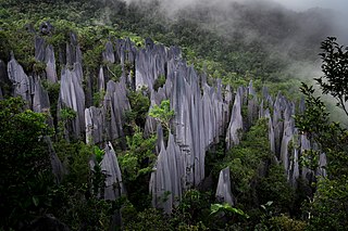
Mount Api is a limestone mountain located in Gunung Mulu National Park in Sarawak, Malaysia. Neighbouring Mount Benarat and Mount Buda are part of the same formation. Mount Api is famous for its striking limestone karst formations, commonly called "the pinnacles".

Deer Cave, located near Miri, Sarawak, Malaysia, is a show cave attraction of Gunung Mulu National Park. It was surveyed in 1961 by G. E. Wilford of the British Borneo Geological Survey, who predicted that Mulu would yield many more caves in the future. The cave, which is also known as Gua Payau or Gua Rusa by the local Penan and Berawan people, is said to have received its name because of the deer that go there to lick salt-bearing rocks and shelter themselves.

The Borneo lowland rain forests is an ecoregion, within the tropical and subtropical moist broadleaf forests biome, of the large island of Borneo in Southeast Asia. It supports approximately 15,000 plant species, 380 bird species and several mammal species. The Borneo lowland rain forests is diminishing due to logging, hunting and conversion to commercial land use.
The Pulong Tau National Park is a national park in Kelabit Highlands in Limbang Division and Miri Division of Sarawak, Malaysia.
Biocyclone Cave is a cave in Gunung Buda National Park, Sarawak, Malaysia. The cave has a 100-metre (330 ft) wide entrance. Its length is 2,278 metres (7,474 ft), with a vertical range of 152 metres (499 ft). It was first explored and surveyed by an American expedition in 1995.

The Clearwater Cave System in Gunung Mulu National Park, Sarawak, Malaysia is believed to be one of the largest interconnected cave systems in the world by volume and the 9th longest cave in the world at 236.796 km (147.138 mi) (2020). The system lies mainly under the western margins of Gunung Api between the Melinau Gorge and Cave of the Winds.
Lithocarpus muluensis is a tree in the beech family Fagaceae. It is named for Gunung Mulu mountain in Sarawak, Borneo.
The Southern Ladan Hills comprise a tract of some 25,000 ha of forested land in the interior of the Belait and Tutong Districts of Brunei, in north-western Borneo, which has been identified by BirdLife International as an Important Bird Area (IBA). Lying at an altitude of 100–300 m, it contains mixed dipterocarp, lower montane, tropical heath and limestone forest. It lies along the international border between Brunei and the Malaysian state of Sarawak, and is contiguous with the Gunung Mulu and Gunung Buda National Parks there.
