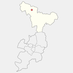
Yeongju is a city in the far north region of North Gyeongsang province in South Korea, covering 668.84 km2 with a population of 113,930 people according to the 2008 census. The city borders Bonghwa county to the east, Danyang county of North Chungcheong province to the west, Andong city and Yecheon county to the south, and Yeongwol county of Gangwon province to the north.

Danyang County is in North Chungcheong Province, South Korea.
Muju County (Muju-gun), is a county in North Jeolla Province (Jeollabuk-do), South Korea. Muju is known for its Muju Firefly Festival and is a tourist area.
Jincheon County is a county in Chungcheongbuk-do Province, South Korea.

Anseong is a city in Gyeonggi Province, South Korea, 80 kilometres (50 mi) south of Seoul. Its geographical location is 37°0′N127°16′E.

Guri is a city in Gyeonggi Province, South Korea. It is located immediately to the east of Seoul, in the heart of the Capital Metropolitan Area.

Dangjin is a city in South Chungcheong Province, South Korea. It stands on the south shore of the Bay of Asan. Dangjin borders Incheon, Pyeongtaek, and Hwaseong by sea, and Seosan, Yesan, and Asan by land. Its name means "Tang ferry," and refers to the historic role of Dangjin's harbor in connecting Korea to the other side of the Yellow Sea. This role continues to be important in the city's economy, which relies on a mixture of agriculture and heavy industry. The city has the same Hanja name (唐津市) as Karatsu in Saga Prefecture, Japan.

Yesan is a county in South Chungcheong Province, South Korea. Famous people from Yesan include independence fighter Yoon Bong-Gil.
Gyeongsan is satellite city in North Gyeongsang Province, South Korea. Its western border abuts the metropolitan city of Daegu, and much of Gyeongsan lies within the Daegu metropolitan area.

Mungyeong is a city in North Gyeongsang Province, South Korea. The local government, economy, and transportation networks are all centered in Jeomchon, the principal town. Mungyeong has a lengthy history, and is known today for its various historic and scenic tourist attractions. The city's name means roughly "hearing good news." Recently, development has been somewhat stagnant with the decline of the coal industry. Since the 1990s, the proportion of people who rely on the tourism industry through Mungyeong Saejae has gradually increased.
Sangju is a city in North Gyeongsang Province, central South Korea. Although Sangju is rather rural, it is very old and was once a key city. Along with Gyeongju, it gives rise to half of the name of the Gyeongsang provinces. Sangju is nicknamed Sam Baek, or "Three Whites", referring to three prominent agricultural products rice, silkworm cocoons, and dried persimmons from the area.

Bonghwa County (Bonghwa-gun) is a county in North Gyeongsang Province, South Korea. It lies inland, at the northern edge of the province, and borders Gangwon province to the north. To the east it is bounded by Yeongyang and Uljin counties, to the south by Andong, and to the west by Yeongju. The county is ringed by the Taebaek and Sobaek Mountains, the highest of which is Taebaeksan (1,566.7m). Because of its mountainous location, Bonghwa has a colder climate than most of the province, with an average annual temperature of 10 °C (50 °F).
Chilgok County (Chilgok-gun) is located at south-west part of North Gyeongsang Province. It is close by Gunwi County on the east while adjoins with Gimchon-si, Seongju County on the west. It is also a transportation hub where the Nakdong river flows through and an Urban-Farming complex that adjoins with Gumi City and Daegu Metropolitan city.

Goryeong County is a county in North Gyeongsang Province, South Korea.
Seongju County (Seongju-gun) is a county in North Gyeongsang Province, South Korea. This largely agricultural area is located immediately west of the metropolitan city of Daegu. The capital of the county is the town of Seongju.

Uiseong County (Uiseong-gun) is a county in Gyeongsangbuk-do Province, South Korea. Located near the center of the province, it is bounded by Andong on the north, Cheongsong on the east, Gunwi County on the south, and Sangju and Yecheon on the west. As in most parts of Korea, most of the land is vacant and forested; only about 19% of the county's area is farmland. The county is largely rural, with an economy dominated by agriculture; the only urbanized area is the county seat, Uiseong-eup.

Yecheon County is a county in the province of North Gyeongsang, South Korea. It is 661 km2 in area, and in 2004 had a population of 52,311. It has lost over 2/3 of its inhabitants since the mid-1960s. It consists of twelve administrative districts. The county borders Yeongju city to the northeast, Andong city to the east, Uiseong county to the southeast, Mungyeong city to the west, Sangju city to the southwest, and Danyang county of North Chungcheong province to the northwest.

Yeongyang County (Yeongyang-gun) is an inland county in the north-eastern area of North Gyeongsang Province, South Korea.
Gimhae is a city in South Gyeongsang Province, South Korea, situated near the Nakdong River.
Geochang County is a county in South Gyeongsang Province, South Korea. The Geochang International Festival of Theater, which was started in 1989, is renowned as the best play festival in Korea. The District Office is located in Geochang-eup, and has jurisdiction over 1 eup and 11 myeon.