Related Research Articles

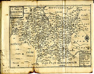
Leicestershire is a ceremonial county in the East Midlands of England. It is bordered by Derbyshire, Nottinghamshire, and Lincolnshire to the north, Rutland to the east, Northamptonshire to the south-east, Warwickshire to the south-west, and Staffordshire to the west. The city of Leicester is the largest settlement and the county town.

John Nichols was an English printer, author and antiquary. He is remembered as an influential editor of the Gentleman's Magazine for nearly 40 years; author of a monumental county history of Leicestershire; author of two compendia of biographical material relating to his literary contemporaries; and as one of the agents behind the first complete publication of Domesday Book in 1783.

Oadby and Wigston is a local government district with borough status in Leicestershire, England. It covers the two towns of Oadby, where the council is based, and Wigston, which is the larger town. Both form part of the Leicester urban area, lying south-east of the city.

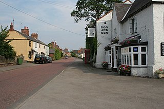
Wigston, or Wigston Magna, is a town in the Oadby and Wigston district of Leicestershire, England, just south of Leicester on the A5199. It had a population of 32,321 in 2011.
Framland was a hundred in north-east Leicestershire, England, roughly corresponding to today's borough of Melton. It was recorded in the Domesday Book as one of Leicestershire's four wapentakes.
Sparkenhoe was a hundred of Leicestershire, England in the south-west of the county, covering Market Bosworth and Hinckley, broadly corresponding to the modern districts of Blaby and Hinckley and Bosworth. The meeting place of the Sparkenhoe Hundred was probably at Shericles Farm near Desford (SK467026), which derives from scirac meaning "the hundred oak". Sparkenhoe hundred was not recorded in the Domesday Book as a wapentake, being formed in 1346 from part of Guthlaxton and Goscote.
Goscote was a wapentake in the county of Leicestershire, England; consisting of the north and north-west of the county. It was recorded in the Domesday Book, but as the wapentakes evolved to form hundreds, was split into East Goscote Hundred and West Goscote Hundred in 1346.
This article is intended to give an overview of the history of Leicestershire.

The Diocese of Leicester is a Church of England diocese based in Leicester and including the current county of Leicestershire. The cathedral is Leicester Cathedral, where the Bishop of Leicester has his episcopal chair.

Scraptoft is a village in Leicestershire, England. It has a population of about 1,500, measured at the 2011 census as 1,804. It lies north of the A47 road east of Leicester, and runs directly into the built up area of Thurnby and Bushby to the south. For local government the village forms part of the district of Harborough, and constitutes a civil parish.
Kilby is a village and civil parish in the Blaby district of Leicestershire, England. Kilby is the easternmost village in the district, and is 6.1 miles (9.8 km) south east of Leicester. Kilby civil parish includes the former parish of Foston and its deserted medieval village. Nearby places are Countesthorpe 2.21 miles (3.56 km), Fleckney 2.12 miles (3.41 km), Arnesby 1.96 miles (3.15 km), Wistow 1.4 miles (2.3 km) and Kilby Bridge 1.18 miles (1.90 km).

Sharnford is a village and civil parish in Blaby of Leicestershire. The parish has a population of about 1,000, measured at the 2011 census as 985. The village is about four miles east of Hinckley, and is near to Aston Flamville, Wigston Parva and Sapcote.

Seagrave is a village and civil parish in the Charnwood district of Leicestershire, England. It has a population of around 500, measured at the 2011 census as 546, It is north of Sileby and close to Thrussington and Barrow upon Soar.

Burton Overy is a village and civil parish in the Harborough district of Leicestershire, about nine miles south-east of Leicester city centre, and not far from Great Glen. According to the 2001 census, the parish had a population of 289., increasing at the 2011 census to 440.

Sheepy is a civil parish in the Borough of Hinckley and Bosworth in Leicestershire, England. It contains the villages of Sheepy Magna, Sheepy Parva, Sibson, Wellsborough, Upton, Pinwall and Cross Hands—collectively 449 homes. At the 2001 census, the parish had a population of 1,192, including Orton on the Hill but falling slightly to 1,174 at the 2011 census.
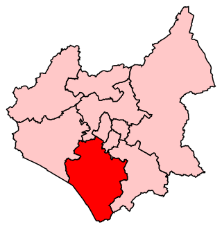
South Leicestershire is a constituency represented in the House of Commons of the UK Parliament since 2015 by Alberto Costa, a member of the Conservative Party.

Claybrooke Magna is a village and civil parish in the Harborough district of Leicestershire, England, close to the A5 trunk road. The village is located between junctions 20 and 21 of the M1, and the towns of Leicester, Rugby, Lutterworth and Market Harborough are easily accessible.
Bushloe High School was a middle school with academy status located in Wigston, Leicestershire, England.
Wigston College, previously known as Guthlaxton College, is a coeducational sixth form located in Wigston Magna in the English county of Leicestershire. The college forms part of The Wigston Academies Trust, together with neighbouring Wigston Academy.
References
- ↑ Open Domesday: Guthlaxton Wapentake, accessed March 2020.
- ↑ "Hundred of Guthlaxton | Domesday Book". Archived from the original on 5 April 2015. Retrieved 28 January 2015. Domesday Map: Guthlaxton
- ↑ Sam Turner, Aspects of the development of public assembly in the Danelaw Archived 2007-07-04 at the Wayback Machine
- ↑ John Curtis, A Topographical History of the County of Leicester (1831)
52°30′N1°12′W / 52.5°N 1.2°W
| | This Leicestershire location article is a stub. You can help Wikipedia by expanding it. |