Gyrotheodolite

Last updated
A Wild GAK gyroscope mounted on a Wild T-16 theodolite. WildT16+GAK sept1989.jpg
A Wild GAK gyroscope mounted on a Wild T-16 theodolite.

In surveying, a gyrotheodolite (also: surveying gyro) is an instrument composed of a gyrocompass mounted to a theodolite. It is used to determine the orientation of true north. It is the main instrument for orientation in mine surveying [1] and in tunnel engineering, where astronomical star sights are not visible and GPS does not work.

Contents

History

In 1852, the French physicist Léon Foucault discovered that a gyro with two degrees of freedom points north. This principle was adapted by Max Schuler in 1921 to build the first surveying gyro. In 1949, the gyro-theodolite – at that time called a "meridian pointer" or "meridian indicator" [2] – was first used by the Clausthal Mining Academy underground. Several years later it was improved with the addition of autocollimation telescopes. In 1960, the Fennel Kassel company produced the first of the KT1 series of gyro-theodolites. [3] Fennel Kassel and others later produced gyro attachments that can be mounted on normal theodolites. [4]

Operation

A gyroscope is mounted in a sphere, lined with Mu-metal to reduce magnetic influence, connected by a spindle to the vertical axis of the theodolite. The battery-powered gyro wheel is rotated at 20,000 rpm or more, until it acts as a north-seeking gyroscope. [2] A separate optical system within the attachment permits the operator to rotate the theodolite and thereby bring a zero mark on the attachment into coincidence with the gyroscope spin axis. By tracking the spin axis as it oscillates about the meridian, a record of the azimuth of a series of the extreme stationary points of that oscillation may be determined by reading the theodolite azimuth circle. A midpoint can later be computed from these records that represents a refined estimate of the meridian. Careful setup and repeated observations can give an estimate that is within about 10 arc seconds of the true meridian. [5] This estimate of the meridian contains errors due to the zero torque of the suspension not being aligned precisely with the true meridian and to measurement errors of the slightly damped extremes of oscillation. These errors can be moderated by refining the initial estimate of the meridian to within a few arc minutes and correctly aligning the zero torque of the suspension. [6]

When the spinner is released from restraint with its axis of rotation aligned close to the meridian, the gyroscopic reaction of spin and Earth's rotation results in precession of the spin axis in the direction of alignment with the plane of the meridian. This is because the daily rotation of the Earth is in effect continuously tilting the east–west axis of the station. The spinner axis then accelerates towards and overshoots the meridian, it then slows to a halt at an extreme point before similarly swinging back towards the initial point of release. This oscillation in azimuth of the spinner axis about the meridian repeats with a period of a few minutes. In practice the amplitude of oscillation will only gradually reduce as energy is lost due to the minimal damping present. [4] Gyro-theodolites employ an undamped oscillating system because a determination can be obtained in less than about 20 minutes, while the asymptotic settling of a damped gyro-compass would take many times that before any reasonable determination of meridian could possibly be made. [1]

When not in operation, the gyroscope assembly is anchored within the instrument. The electrically powered gyroscope is started while restrained and then released for operation. During operation the gyroscope is supported within the instrument assembly, typically on a thin vertical tape that constrains the gyroscope spinner axis to remain horizontal. The alignment of the spin axis is permitted to rotate in azimuth by only the small amount required during operation. An initial approximate estimate of the meridian is needed. This might be determined with a magnetic compass, from an existing survey network or by the use of the gyro-theodolite in an extended tracking mode.

Uses

Gyro-theodolites are primarily used in the absence of astronomical star sights and GPS. For example, where a conduit must pass under a river, a vertical shaft on each side of the river might be connected by a horizontal tunnel. A gyro-theodolite can be operated at the surface and then again at the foot of the shafts to identify the directions needed to tunnel between the base of the two shafts. [7] During the construction of the Channel Tunnel, which runs under the English Channel from France to the UK, gyro-theodolites were used to align the tunnels. [8]

Limitations

Although a gyro-theodolite functions at the equator and in both the northern and southern hemispheres, it cannot be used at either the North Pole or South Pole, where the Earth's axis is precisely perpendicular to the horizontal axis of the spinner and the meridian is undefined. Gyro-theodolites are not normally used within about 15 degrees of the pole where the angle between the earth's rotation and the direction of gravity is too small for it to work reliably.

Unlike an artificial horizon or inertial navigation system, a gyro-theodolite cannot be relocated while it is operating. It must be restarted again at each site.

When available, astronomical star sights are able to give the meridian bearing to better than one hundred times [ citation needed ] the accuracy of the gyro-theodolite. Where this extra precision is not required, the gyro-theodolite is able to produce a result quickly without the need for night observations.

Related Research Articles

<span class="mw-page-title-main">Geodesy</span> Science of measuring the shape, orientation, and gravity of the Earth and other astronomical bodies

Geodesy is the science of measuring and representing the geometry, gravity, and spatial orientation of the Earth in temporally varying 3D. It is called planetary geodesy when studying other astronomical bodies, such as planets or circumplanetary systems.

<span class="mw-page-title-main">Latitude</span> Geographic coordinate specifying north–south position

In geography, latitude is a coordinate that specifies the north–south position of a point on the surface of the Earth or another celestial body. Latitude is given as an angle that ranges from –90° at the south pole to 90° at the north pole, with 0° at the Equator. Lines of constant latitude, or parallels, run east–west as circles parallel to the equator. Latitude and longitude are used together as a coordinate pair to specify a location on the surface of the Earth.

<span class="mw-page-title-main">Precession</span> Periodic change in the direction of a rotation axis

Precession is a change in the orientation of the rotational axis of a rotating body. In an appropriate reference frame it can be defined as a change in the first Euler angle, whereas the third Euler angle defines the rotation itself. In other words, if the axis of rotation of a body is itself rotating about a second axis, that body is said to be precessing about the second axis. A motion in which the second Euler angle changes is called nutation. In physics, there are two types of precession: torque-free and torque-induced.

<span class="mw-page-title-main">Gyroscope</span> Device for measuring or maintaining orientation and angular velocity

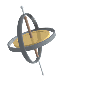
A gyroscope is a device used for measuring or maintaining orientation and angular velocity. It is a spinning wheel or disc in which the axis of rotation is free to assume any orientation by itself. When rotating, the orientation of this axis is unaffected by tilting or rotation of the mounting, according to the conservation of angular momentum.

<span class="mw-page-title-main">Gyrocompass</span> Type of non-magnetic compass based on the rotation of the Earth

A gyrocompass is a type of non-magnetic compass which is based on a fast-spinning disc and the rotation of the Earth to find geographical direction automatically. The use of a gyrocompass is one of the seven fundamental ways to determine the heading of a vehicle. A gyroscope is an essential component of a gyrocompass, but they are different devices; a gyrocompass is built to use the effect of gyroscopic precession, which is a distinctive aspect of the general gyroscopic effect. Gyrocompasses are widely used for navigation on ships, because they have two significant advantages over magnetic compasses:

<span class="mw-page-title-main">Azimuth</span> Horizontal angle from north or other reference cardinal direction

An azimuth is an angular measurement in a spherical coordinate system. More specifically, it is the horizontal angle from a cardinal direction, most commonly north.

<span class="mw-page-title-main">Equatorial coordinate system</span> Celestial coordinate system used to specify the positions of celestial objects

The equatorial coordinate system is a celestial coordinate system widely used to specify the positions of celestial objects. It may be implemented in spherical or rectangular coordinates, both defined by an origin at the centre of Earth, a fundamental plane consisting of the projection of Earth's equator onto the celestial sphere, a primary direction towards the vernal equinox, and a right-handed convention.

<span class="mw-page-title-main">Foucault pendulum</span> Device to demonstrate Earths rotation

The Foucault pendulum or Foucault's pendulum is a simple device named after French physicist Léon Foucault, conceived as an experiment to demonstrate the Earth's rotation. A long and heavy pendulum suspended from the high roof above a circular area was monitored over an extended time period, showing that the plane of oscillation rotated.

<span class="mw-page-title-main">Theodolite</span> Optical surveying instrument

A theodolite is a precision optical instrument for measuring angles between designated visible points in the horizontal and vertical planes. The traditional use has been for land surveying, but it is also used extensively for building and infrastructure construction, and some specialized applications such as meteorology and rocket launching.

<span class="mw-page-title-main">Telescope mount</span> Mechanical structure which supports a telescope

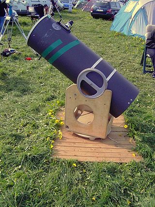
A telescope mount is a mechanical structure which supports a telescope. Telescope mounts are designed to support the mass of the telescope and allow for accurate pointing of the instrument. Many sorts of mounts have been developed over the years, with the majority of effort being put into systems that can track the motion of the fixed stars as the Earth rotates.

<span class="mw-page-title-main">Altazimuth mount</span> Support mechanism with rotation about the horizontal and vertical axes

An altazimuth mount or alt-azimuth mount is a simple two-axis mount for supporting and rotating an instrument about two perpendicular axes – one vertical and the other horizontal. Rotation about the vertical axis varies the azimuth of the pointing direction of the instrument. Rotation about the horizontal axis varies the altitude angle of the pointing direction.

Geodetic astronomy or astronomical geodesy (astro-geodesy) is the application of astronomical methods into geodetic networks and other technical projects of geodesy.

<span class="mw-page-title-main">Meridian circle</span> Astronomical instrument for timing of the passage of stars

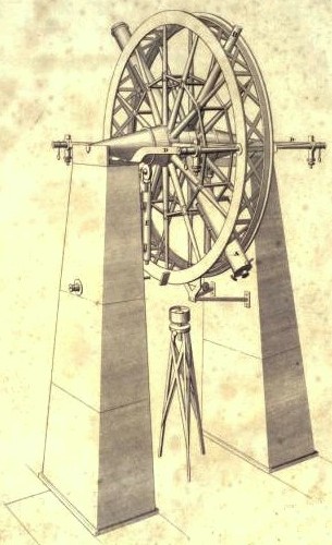
The meridian circle is an instrument for timing of the passage of stars across the local meridian, an event known as a culmination, while at the same time measuring their angular distance from the nadir. These are special purpose telescopes mounted so as to allow pointing only in the meridian, the great circle through the north point of the horizon, the north celestial pole, the zenith, the south point of the horizon, the south celestial pole, and the nadir. Meridian telescopes rely on the rotation of the sky to bring objects into their field of view and are mounted on a fixed, horizontal, east–west axis.

<span class="mw-page-title-main">Gyro monorail</span>

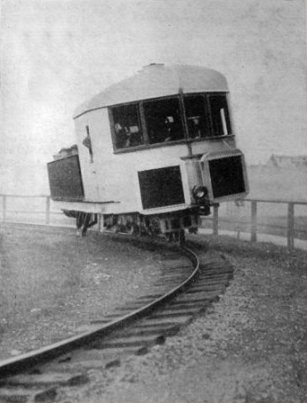
The gyro monorail, gyroscopic monorail, gyro-stabilized monorail, or gyrocar are terms for a single rail land vehicle that uses the gyroscopic action of a spinning wheel to overcome the inherent instability of balancing on top of a single rail.

A Rate integrating gyroscope is a rate gyro with a built in integrator. It is usually a component of an Inertial Measurement Unit or a stabilization system.

<span class="mw-page-title-main">Transit instrument</span> Small telescope used for precise astrometry

In astronomy, a transit instrument is a small telescope with extremely precisely graduated mount used for the precise observation of star positions. They were previously widely used in astronomical observatories and naval observatories to measure star positions in order to compile nautical almanacs for use by mariners for celestial navigation, and observe star transits to set extremely accurate clocks which were used to set marine chronometers carried on ships to determine longitude, and as primary time standards before atomic clocks. The instruments can be divided into three groups: meridian, zenith, and universal instruments.

<span class="mw-page-title-main">Inertial navigation system</span> Continuously computed dead reckoning

An inertial navigation system (INS) is a navigation device that uses motion sensors (accelerometers), rotation sensors (gyroscopes) and a computer to continuously calculate by dead reckoning the position, the orientation, and the velocity of a moving object without the need for external references. Often the inertial sensors are supplemented by a barometric altimeter and sometimes by magnetic sensors (magnetometers) and/or speed measuring devices. INSs are used on mobile robots and on vehicles such as ships, aircraft, submarines, guided missiles, and spacecraft. Other terms used to refer to inertial navigation systems or closely related devices include inertial guidance system, inertial instrument, inertial measurement unit (IMU) and many other variations. Older INS systems generally used an inertial platform as their mounting point to the vehicle and the terms are sometimes considered synonymous.

<span class="mw-page-title-main">LN-3 inertial navigation system</span>

The LN-3 inertial navigation system is an inertial navigation system (INS) that was developed in the 1960s by Litton Industries. It equipped the Lockheed F-104 Starfighter versions used as strike aircraft in European forces. An inertial navigation system is a system which continually determines the position of a vehicle from measurements made entirely within the vehicle using sensitive instruments. These instruments are accelerometers which detect and measure vehicle accelerations, and gyroscopes which act to hold the accelerometers in proper orientation.

Spacecraft attitude control is the process of controlling the orientation of a spacecraft with respect to an inertial frame of reference or another entity such as the celestial sphere, certain fields, and nearby objects, etc.

<span class="mw-page-title-main">Burt's solar compass</span> Surveying instrument that uses the suns direction instead of magnetism

Burt's solar compass or astronomical compass is a surveying instrument that makes use of the Sun's direction instead of magnetism. William Austin Burt invented his solar compass in 1835. The solar compass works on the principle that the direction to the Sun at a specified time can be calculated if the position of the observer on the surface of the Earth is known, to a similar precision. The direction can be described in terms of the angle of the Sun relative to the axis of rotation of the planet.

References

  1. 1 2 Wang Hong-lan (September 1987), "Analysis of the motion of a gyro-theodolite", Applied Mathematics and Mechanics, 8 (9): 889–900, doi:10.1007/BF02019527, S2CID   121190508
  2. 1 2 Staley, William Wesley (1964), Introduction to mine surveying, Stanford University Press, pp. 169–170, ISBN   0-8047-0361-2
  3. Deumlich, Fritz (1982), Surveying instruments, Walter de Gruyter, p. 18, ISBN   3-11-007765-5
  4. 1 2 Heribert Kahmen, Wolfgang Faig (1988), Surveying, Walter de Gruyter, pp. 112–116, ISBN   3-11-008303-5
  5. Smith, James Raymond (1997), Introduction to geodesy: the history and concepts of modern geodesy, Wiley-IEEE, p. 174, ISBN   0-471-16660-X
  6. Wilfred Schofield, Mark Breach (2007), Engineering surveying, Butterworth-Heinemann, pp. 519–533, ISBN   978-0-7506-6949-8
  7. N. Korittke; H. Klapperich (1998), "Application of high precision gyro-theodolites in tunneling", in Arsenio Negro; Argimiro A. Ferreira (eds.), Tunnels and metropolises: proceedings of the World Tunnel Congress'98 on tunnels and metropolises : Sao Paulo, Brazil, 25-30 april 1998, Taylor & Francis, pp. 823–827, ISBN   90-5410-936-X
  8. Kirkland, Colin J. (1995), Engineering the Channel Tunnel, Taylor & Francis, pp. 55–56, ISBN   0-419-17920-8