Hafslovatnet

Last updated
Hafslovatnet
Hafslovatnet Norway.jpg
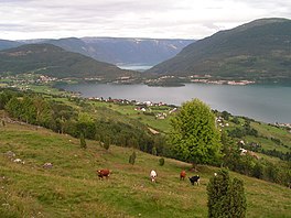
Hafslovatnet with the Lustrafjord in the background
Norway Vestland adm location map.svg
Red pog.svg
Hafslovatnet
Location of the lake
Relief Map of Norway.png
Red pog.svg
Hafslovatnet
Hafslovatnet (Norway)
Location Luster, Vestland
Coordinates 61°18′07″N07°10′19″E / 61.30194°N 7.17194°E / 61.30194; 7.17194
Primary inflows Soget
Primary outflows Årøyelvi
Basin  countries Norway
Max. length8 km (5.0 mi)
Max. width1.5 km (0.93 mi)
Surface area5.97 km2 (2.31 sq mi)
Average depth22 m (72 ft)
Max. depth72.5 m (238 ft)
Water volume130,432,000 m3 (4.6062×10⁹ cu ft)
Surface elevation168 m (551 ft)
Settlements Hafslo
References NVE

Hafslovatnet is a lake in the municipality of Luster in Vestland county, Norway.

Contents

The lake lies at an elevation of 168 m (551 ft), [1] has a surface area of 5.97 km2 (2.31 sq mi), and a water volume of 130,432,000 m3 (4.6062×10⁹ cu ft). [2] It serves as a reservoir for the hydroelectric power station in Årøy. [1] The primary inflow of the Hafslovatnet is via the short river Soget from the lake Veitastrondsvatnet. The primary outflow is the river Årøyelvi, which flows south into the Barsnesfjord, an inner part of the Sogndalsfjord, which, in turn, is a northern branch of the Sognefjord. [3]

The eponymous village of Hafslo lies at the northern shore of the lake. The eastern end of the lake lies at a distance of less than 2 km (1.2 mi) from the village of Solvorn, which lies at the northern shore of the Lustrafjord. The western part of the lake lies in the bird reserve Hafslovatnet. [3]

See also

Related Research Articles

<span class="mw-page-title-main">Mjøsa</span> Largest lake in Norway

Mjøsa is Norway's largest lake, as well as one of the deepest lakes in Norway and in Europe. It is the fourth-deepest lake in Norway. It is located in the southern part of Norway, about 100 kilometres (62 mi) north of the city of Oslo. Its main tributary is the river Gudbrandsdalslågen flowing in from the north; the only distributary is the river Vorma in the south. Inflows would theoretically need 5.6 years to fill the lake. With an average depth of about 150 metres (490 ft), most of the lake's volume is under sea level. The average outflow of the lake (measured from 1931–1982) is 316 cubic metres per second (11,200 cu ft/s) which is about 9,959,000,000 cubic metres per year (1.1145×10¹⁰ cu ft/Ms). Mjøsa contains about 56.2 km3 (13.5 cu mi) of water compared to the 14.8 km3 (3.6 cu mi) in the lake Røssvatnet, the second largest lake by volume in Norway.

<span class="mw-page-title-main">Storsjøen (Rendalen)</span> Lake in Rendalen and Åmot, Hedmark, Norway

Storsjøen is the ninth-deepest lake in Norway at 309 metres (1,014 ft) in depth. The 48.09-square-kilometre (18.57 sq mi) lake lies in Rendalen and Åmot municipalities which are in Innlandet county, Norway. The lake is 35 kilometres (22 mi) long, but only 1.7 kilometres (1.1 mi) wide at its broadest point. The lake lies 252 metres (827 ft) above sea level, has an area of 48.09 square kilometres (18.57 sq mi), and a volume of 6.69 km3 (1.61 cu mi).

Holmvatnet is a lake and a reservoir in the municipality of Rana in Nordland county, Norway. It is located northeast of the villages of Mæla and Myklebustad.

<span class="mw-page-title-main">Einavatnet</span> Lake in Innlandet, Norway

Einavatnet is a lake which lies in Vestre Toten Municipality in Innlandet county, Norway. The 13.82-square-kilometre (5.34 sq mi) lake lies at an elevation of 398 metres (1,306 ft) above sea level. The lake lies in the southern portion of the municipality, about 12 kilometres (7.5 mi) south of the municipal centre, Raufoss. The village of Eina lies at the northern end of the lake. The Eina Church is located on the eastern shore of the lake. The Norwegian National Road 4 runs along the eastern shore of the lake. The river Hunnselva flows north out of the lake towards the town of Gjøvik where it drains into the large lake Mjøsa.

<span class="mw-page-title-main">Oltedalsvatnet</span> Lake in Gjesdal, Norway

Oltedalsvatnet is a lake in the municipality of Gjesdal in Rogaland county, Norway. The 3.12-square-kilometre (1.20 sq mi) lake lies just south of the village of Oltedal. It is a reservoir along the river Oltedalsåna that is used to store water for the Oltedal Hydroelectric Power Station. The lake sits at an elevation of 101.5 to 112.5 metres and it holds about 28,800,000 cubic metres.

<span class="mw-page-title-main">Viddalsdammen</span> Lake in Aurland, Norway

Viddalsdammen is a lake and a reservoir in Aurland Municipality in Vestland county, Norway. The reservoir has an area of 4.13-square-kilometre (1.59 sq mi) and the elevation varies between 930 metres (3,050 ft) and 868 m (2,848 ft) above sea level. Viddalsdammen is located at the end of the Låvisdalen valley, about 11 kilometres (6.8 mi) southeast of the village of Aurlandsvangen, about 7 kilometres (4.3 mi) southeast of the village of Flåm, and about 6 kilometres (3.7 mi) northeast of Myrdal Station.

<span class="mw-page-title-main">Toke (lake)</span> Lake in Telemark, Norway

Toke is a lake in Vestfold og Telemark county, Norway. The lake is located primarily in Drangedal Municipality, but it also extends a little into Kragerø Municipality and Bamble Municipality. The lake consists of several areas: Upper Toke and Lower Toke, which is connected via Straumen, literally 'the stream'. At the north end of Upper Toke is the village of Prestestranda. In the south, the eastern arm of Lower Toke (Rørholtfjorden) reaches into Bamble municipality and the southern part reaches into Kragerø, where its outlet is the river Lundereidelva where the Dalfoss hydroelectric plant is located. The lake, with its inflow, constitutes the majority of the Kragerø watershed.

Edlandsvatnet is a lake in the municipality of Gjesdal in Rogaland county, Norway. The 2.11-square-kilometre (0.81 sq mi) lake lies just south of the large village of Ålgård, immediately southwest of the lake Limavatnet. The European route E39 highway runs along the northern shore of the lake. The lake empties into the river Figgjoelva on the northwestern end of the lake. The lake has many brown trout in it.

Flassavatnet is a lake in Rogaland county, Norway. The lake lies on the border of the municipalities of Gjesdal and Sandnes. The 0.9243-square-kilometre (0.3569 sq mi) lake sits about 1 kilometre (0.62 mi) north of the large village of Ålgård, not far north of the lakes Edlandsvatnet and Limavatnet. The lake is a reservoir with a small dam on the southern edge of the lake. The water level is kept at about 177 metres (581 ft) above sea level. The reservoir holds about 900,000 cubic metres.

Langsjøen is a lake in the municipalities of Tolga and Engerdal in Innlandet county, Norway. The 6.35-square-kilometre (2.45 sq mi) lake lies in the Sømådalen valley in the southeastern part of the municipality, just west of the large lake Femund. The village of Øversjødalen lies at the north end of the lake and the mountain Elgspiggen lies about 10 kilometres (6.2 mi) west of the lake.

<span class="mw-page-title-main">Lomnessjøen</span> Lake in Rendalen, Norway

Lomnessjøen is a lake in Rendalen Municipality in Innlandet county, Norway. The villages Åkre and Otnes are located on the shores of the lake. The lake is part of the Renaelva river system. The Renaelva river flows into the lake from the north. The south end of the river drains into the larger lake Storsjøen which is about 3 kilometres (1.9 mi) to the south of this lake.

Falningsjøen is a lake in Tynset Municipality in Innlandet county, Norway. The lake lies about 4.5 kilometres (2.8 mi) northeast of the village of Yset. The Ya River begins at this lake. The Forollhogna National Park boundary lies at the north end of the lake.

Galtsjøen is a lake on the border of the municipalities of Rendalen and Engerdal in Innlandet county, Norway. The 3.5-square-kilometre (1.4 sq mi) lake is considered the headwaters of the river Femundselva which flows south into Sweden. The lake inlet is through the Galtstrømmen which comes from the small lake Galthåen which in turn has an inlet from the lake Isteren and Femund. The lake Sølensjøen lies about 2.5 kilometres (1.6 mi) to the west of Galtsjøen.

Harrsjøen is a lake in Rendalen Municipality in Innlandet county, Norway. The 2.31-square-kilometre (0.89 sq mi) lake lies about 3 kilometres (1.9 mi) southwest of the village of Bergset and about 8 kilometres (5.0 mi) northeast of the village of Hanestad. The lake has an outlet in the south through the river Hårenna, a tributary of the river Renaelva.

Innerdalsvatnet is a lake in Tynset Municipality in Innlandet county, Norway. It is a significant part of the Orkla watershed. The 5.88-square-kilometre (2.27 sq mi) lake lies about 10 kilometres (6.2 mi) west of the village of Yset. The northwest end of the lake has a large dam on it to control the level of the water for hydropower. The dam is actually located on the municipal and county border. The lake holds about 150,000,000 cubic metres (4.0×10¹⁰ US gal) of water which is run through a long tunnel to two nearby power stations.

Siksjøen is a lake in the municipality of Os in Innlandet county, Norway. The 2.69-square-kilometre (1.04 sq mi) lake is located in the Tufsingdalen valley in the southeastern part of the municipality, about 25 kilometres (16 mi) southeast of the village of Os.

<span class="mw-page-title-main">Sølensjøen</span>

Sølensjøen is a lake in Rendalen Municipality in Innlandet county, Norway. The 22.43-square-kilometre (8.66 sq mi) lake is part of the 46-mile (74 km) long Sølna river system. The lake itself is about 14 kilometres (8.7 mi) long and 3 kilometres (1.9 mi) wide, and its greatest depth is 58 metres (190 ft). Sølensjøen has abundant populations of Arctic char, trout, grayling, whitefish, pike, burbot and perch, which has made it the locale of Norway's largest inland fishing village Fiskevollen which is located on its northwestern shore. The mountain Sølen lies about 5 kilometres (3.1 mi) to the southwest of the lake.

<span class="mw-page-title-main">Hafslo (village)</span> Village in Western Norway, Norway

Hafslo is a village in Luster Municipality in Vestland county, Norway. The village is located on the northern shore of the lake Hafslovatnet, about 3 kilometres (1.9 mi) northwest of the village of Solvorn which sits on the shores of the Lustrafjorden. The lake Veitastrondvatnet is located to the northwest of Hafslo. The village of Sogndalsfjøra lies 15 kilometres (9.3 mi) to the south; the village of Gaupne lies about 15 kilometres (9.3 mi) to the north; and the village of Veitastrond lies about 25 kilometres (16 mi) to the northwest. The Norwegian County Road 55 runs through the village on its way from Sogndalsfjøra to Gaupne.

Venneslafjorden is a lake in the municipality of Vennesla in Agder county, Norway. The 1.56-square-kilometre (390-acre) lake is located along the river Otra. There are several islands and islets located in the northern part of the lake, the largest of which is Drivenesøya. The village of Vennesla is located along the southern end and there are also settlements that extend along the east side of the lake. The lake is dammed as a reservoir for the Hunsfos hydropower plants.

<span class="mw-page-title-main">Sjønstå River</span> River in Fauske, Norway

The Sjønstå River is a river in the municipality of Fauske in Nordland county, Norway. The river is located in the valley between the town of Fauske and the village of Sulitjelma.

References

  1. 1 2 "NVE Atlas" (in Norwegian). Norwegian Water Resources and Energy Directorate. Map layer: Vannkraft – Utbygd vannkraft – Magasin. Retrieved 2021-05-26.
  2. "NVE Atlas" (in Norwegian). Norwegian Water Resources and Energy Directorate. Map layer: Vassdrag – Innsjødatabase – Dybdekart. Retrieved 2021-05-26.
  3. 1 2 Store norske leksikon. "Hafslovatnet" (in Norwegian). Retrieved 2021-05-26.