Hagersville, Ontario

Last updated

Hagersville
Unincorporated Community
Hagersville, ON.jpg
Canada Ontario location map 2.svg
Red pog.svg
Hagersville
Canada location map 2.svg
Red pog.svg
Hagersville
Coordinates: 42°57′35.6″N80°03′08.3″W / 42.959889°N 80.052306°W / 42.959889; -80.052306
CountryCanada
Province Ontario
County Haldimand
Government
  Mayor of HaldimandShelley Ann Bentley [1]
  Governing bodyThe Council of the Corporation of Haldimand County
  Ward 4 (Hagersville) CouncillorMarie Trainer
   MP Leslyn Lewis (Conservative)
   MPP Bobby Ann Brady (Independent)
Area
  Land3.15 km2 (1.22 sq mi)
Elevation
223 m (732 ft)
Population
 (2021)
  Total3,059
  Density971.5/km2 (2,516/sq mi)
Demonym Hagersvillian
Time zone UTC−05:00 (EST)
  Summer (DST) UTC−04:00 (EDT)
Forward sortation area
N0A
Area code(s) 905, 289, 365

Hagersville is a community in Haldimand County, Ontario in Canada.

Contents

History

Upon the construction of Highway 6, known formerly as the Plank Road, a small village popped up around 1855 when Charles and David Hager bought most of the land in the centre of the area. David Almas owned the land on the east side of the road, while John Porter owned the land in the west end.

The building of the Canada Southern Railroad in 1870, and of the Hamilton and Lake Erie Railway three years later helped to make Hagersville a prosperous village in 1879.

Close by the rail crossing was The Junction Hotel, later becoming The Lawson Hotel after a change in ownership. Perhaps it was best known as Murph's Place when retired NHL player Ron Murphy took ownership. It was also known as the Hagersville Inn, but today it is known as The Old Lawson House. In 1852, Charles Hager built a frame hotel at the corner of the Plank Road and Indian Line. Hagersville's first post office was in this hotel and Joseph Seymour suggested the community be called Hagersville to honour the Hager brothers. As of 2020, the Lawson property offered rooms as affordable housing for many residents.

Historical plaque at the site of No. 16 Service Flying Training School RCAF No. 16 SFTS Historical Plaque.JPG
Historical plaque at the site of No. 16 Service Flying Training School

During World War II No. 16 Service Flying Training School RCAF was established by the Royal Canadian Air Force as part of the British Commonwealth Air Training Plan [2] [3] at 274 Concession 11 Walpole 3.5 km (2.2 mi) southwest of Hagersville. No. 16 SFTS opened on 8 August 1941 and closed on 30 March 1945. After the RCAF finished with the site it was used by the Canadian Army for various purposes and was known as Camp Hagersville. The camp was closed in 1964. [4] Between the 1960s and 1990s, the camp was used as a residence for youth and then a flea market. As of 2013 the site was an industrial park. Some of the military homes are still there, and the housing area is known as "White Oaks Village". A good view of the site and the old hangars is had from Concession 10 Walpole. The base was located at 42°55′42″N080°07′33″W / 42.92833°N 80.12583°W / 42.92833; -80.12583 (Hagersville Airport) . [5]

In 1990, a large uncontrolled tire fire emitted fumes of toxic smoke into the atmosphere for seventeen days. The fire itself occurred in Townsend, a neighbouring community, but media credited it to Hagersville due to Townsend's relatively unknown status in the area. The so-called "Hagersville Tire Fire" has reportedly been linked to long-term health issues, including some "rare, aggressive cancers," among firefighters who experienced the event first-hand. [6] [7] [8] [9]


Location and airports

Climate

Climate data for Hagersville
MonthJanFebMarAprMayJunJulAugSepOctNovDecYear
Record high °C (°F)15
(59)
18
(64)
25.5
(77.9)
30.5
(86.9)
32.5
(90.5)
35.5
(95.9)
38.5
(101.3)
36.5
(97.7)
32
(90)
28.5
(83.3)
20
(68)
18
(64)
38.5
(101.3)
Mean daily maximum °C (°F)−0.7
(30.7)
−0.2
(31.6)
5.1
(41.2)
12.1
(53.8)
19.4
(66.9)
24.5
(76.1)
26.9
(80.4)
25.5
(77.9)
21.1
(70.0)
14.4
(57.9)
7.2
(45.0)
1.2
(34.2)
13.1
(55.6)
Daily mean °C (°F)−4.4
(24.1)
−4.1
(24.6)
0.7
(33.3)
7
(45)
13.7
(56.7)
18.8
(65.8)
21.3
(70.3)
20.1
(68.2)
15.9
(60.6)
9.8
(49.6)
3.7
(38.7)
−2.1
(28.2)
8.4
(47.1)
Mean daily minimum °C (°F)−8
(18)
−8
(18)
−3.8
(25.2)
1.8
(35.2)
7.9
(46.2)
13
(55)
15.7
(60.3)
14.6
(58.3)
10.6
(51.1)
5
(41)
0.1
(32.2)
−5.3
(22.5)
3.6
(38.5)
Record low °C (°F)−26.5
(−15.7)
−26
(−15)
−20
(−4)
−11
(12)
−2.5
(27.5)
2
(36)
4.5
(40.1)
4
(39)
−2
(28)
−6
(21)
−14
(7)
−23
(−9)
−26.5
(−15.7)
Average precipitation mm (inches)61.8
(2.43)
48.2
(1.90)
75.7
(2.98)
80.6
(3.17)
76.9
(3.03)
84.7
(3.33)
88.2
(3.47)
85.8
(3.38)
94.1
(3.70)
83.2
(3.28)
86.9
(3.42)
73.9
(2.91)
939.9
(37.00)
Source: Environment Canada [10]

Demographics and area

Hagersville is a population centre with a land area of 3.17 km2 (1.22 sq mi).

Hagersville's 2021 population was 3,059, a 4.1% growth from the 2016 population. [11]

Hagersville's 2016 population was 2,815, a 14% growth from the 2011 population of 2,579. [12] Of the total population, 87.5% are European, 9% are First Nation and 3.5% are visible minorities (mostly Filipino, South Asian and Latin American). [12]

Hagersville is adjacent to Mississaugas of the Credit and Six Nations of the Grand River First Nation reserves.

Canada census – Hagersville community profile
2021 2016
Population3,059 (+4.1% from 2016)2,939 (+14.0% from 2011)
Land area3.15 km2 (1.22 sq mi)3.17 km2 (1.22 sq mi)
Population density971.5/km2 (2,516/sq mi)926.3/km2 (2,399/sq mi)
Median age45.2 (M: 43.6, F: 46.4)45.1 (M: 43.8, F: 44.8)
Private dwellings1,290 (total) 1,225 (total) 
Median household income$82,000$68,352
References: 2021 [13] 2016 [14] earlier [15] [16]

Ethnicity

Only those populations which compose more than 1% of the population have been included.

Ethnic Groups in the Community of Hagersville, Ontario (2021)
Ethnic
Group
2021 [17] 2016 [18]
Pop. % Pop. %
Canadian 5551,170
English 1,080930
Irish 600530
Scottish 720635
French [lower-alpha 1] 185225
German 450440
Italian 205200
Ukrainian 50115
Dutch 210210
Polish 9060
Norwegian 3510
Portuguese 4520
American 4520
Hungarian 10050
Mohawk 35
Total responses2,9702,820
Total population3,0592,939
Note: Totals greater than 100% due to multiple origin responses.

Language

As of the 2021 census, there were 2,920 citizens that spoke English only, 70 that spoke both official languages and 5 that spoke neither. [17]

Religion

As of the 2021 census, there were 1,655 citizens identifying as Christian and 1,295 as non-religious and secular perspectives. [17]

Education

Public education in Hagersville is administered by the Grand Erie District School Board and the Catholic schools by the Brant Haldimand Norfolk Catholic District School Board. Schools located in Hagersville include:

Activities

Parks

Annual

Notable people

Notes

  1. Statistic includes all individuals that identified as having a French origin but not otherwise specified.

Related Research Articles

<span class="mw-page-title-main">Brampton</span> City in Ontario, Canada founded 1853

Brampton is a city in the Canadian province of Ontario. It is part of the Greater Toronto Area (GTA) and is a lower-tier municipality within Peel Region. The city has a population of 656,480 as of the 2021 Census, making it the ninth most populous municipality in Canada and the third most populous city in the Greater Golden Horseshoe urban area, behind Toronto and Mississauga.

<span class="mw-page-title-main">Brantford</span> City in Ontario, Canada

Brantford is a city in Ontario, Canada, founded on the Grand River in Southwestern Ontario. It is surrounded by Brant County, but is politically separate with a municipal government of its own that is fully independent of the county's municipal government.

<span class="mw-page-title-main">Regional Municipality of Durham</span> Regional municipality in Ontario, Canada

The Regional Municipality of Durham, informally referred to as Durham Region, is a regional municipality in Southern Ontario, Canada. Located east of Toronto and the Regional Municipality of York, Durham forms the east-end of the Greater Toronto Area and part of the Golden Horseshoe region. It has an area of approximately 2,500 km2 (970 sq mi). The regional government is headquartered in Whitby.

<span class="mw-page-title-main">Golden Horseshoe</span> Secondary region in Ontario, Canada

The Golden Horseshoe is a secondary region of Southern Ontario, Canada, which lies at the western end of Lake Ontario, with outer boundaries stretching south to Lake Erie and north to Lake Scugog, Lake Simcoe and Georgian Bay of Lake Huron. The region is the most densely populated and industrialized in Canada. Based on the 2021 census, with a population of 7,759,635 people in its core and 9,765,188 in its greater area, the Golden Horseshoe accounts for over 20 percent of the population of Canada and more than 54 percent of Ontario's population. It is part of the Quebec City–Windsor Corridor, itself part of the Great Lakes megalopolis.

<span class="mw-page-title-main">Northumberland County, Ontario</span> County in Ontario, Canada

Northumberland County is an upper-tier municipality situated on the north shore of Lake Ontario, east of Toronto in Central Ontario. The Northumberland County headquarters are located in Cobourg.

<span class="mw-page-title-main">Caledonia, Ontario</span> Unincorporated community in Ontario, Canada

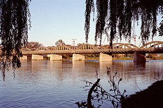
Caledonia is a community located on the Grand River in Haldimand County, Ontario, Canada. It had a population of 12,179 as of the 2021 Canadian Census. Caledonia is within Ward 3 of Haldimand County. The Councillor elected for Ward 3 is Dan Lawrence. As of 2021, there were 4,310 private dwellings in Caledonia.

<span class="mw-page-title-main">Regional Municipality of Niagara</span> Regional municipality in Ontario, Canada

The Regional Municipality of Niagara, also colloquially known as the Niagara Region or Region of Niagara, is a regional municipality comprising twelve municipalities of Southern Ontario, Canada. The regional seat is in Thorold. It is the southern end of the Golden Horseshoe, the largest megalopolis in Canada.

<span class="mw-page-title-main">County of Brant</span> City in Ontario, Canada

The County of Brant is a single-tier municipality in the Canadian province of Ontario. Although it retains the word "county" in its name, the municipality is a single-tier municipal government and has no upper tier. The County of Brant has service offices in Burford, Paris, Oakland, Onondaga and St. George. The largest population centre is Paris.

<span class="mw-page-title-main">Haldimand County</span> City in Ontario, Canada

Haldimand County is a rural city-status single-tier municipality on the Niagara Peninsula in Southern Ontario, Canada, on the north shore of Lake Erie, and on the Grand River. Despite its name, it is no longer a county by definition, as all municipal services are handled by a single level of government. Municipal offices are located in Cayuga.

<span class="mw-page-title-main">Norfolk County, Ontario</span> City in Ontario, Canada

Norfolk County is a rural single-tier municipality on the north shore of Lake Erie in Southwestern Ontario, Canada with a 2016 population of 67,490. Despite its name, it is no longer a county by definition, as all municipal services are handled by a single level of government. The largest community in Norfolk County is Simcoe, whose 2016 population was 13,922. The other population centres are Port Dover, Delhi, Waterford and Port Rowan, and there are many smaller communities. For several years in the late 20th century, the county was merged with Haldimand County but the merged entity was dissolved in 2000.

<span class="mw-page-title-main">Dufferin County</span> County in Ontario, Canada

Dufferin County is a county and census division located in Central Ontario, Canada. The county seat is Orangeville, and the current Warden is Wade Mills. The current chief administrative officer is Sonya Pritchard. Dufferin covers an area of 1,486.31 square kilometres (573.87 sq mi), and its population was 61,735 at the time of the 2016 Census.

<span class="mw-page-title-main">Dunnville</span> Unincorporated community in Ontario, Canada

Dunnville is an unincorporated community located near the mouth of the Grand River in Haldimand County, Ontario, Canada, near the historic Talbot Trail. It was formerly an incorporated town encompassing the surrounding area with a total population of 12,000.

<span class="mw-page-title-main">Duncan, British Columbia</span> City in British Columbia, Canada

Duncan is a city on southern Vancouver Island in British Columbia, Canada. It is the smallest city by area in Canada. It was incorporated in 1912.

<span class="mw-page-title-main">Castlegar, British Columbia</span> City in British Columbia, Canada

Castlegar is a community in the West Kootenay region of British Columbia, Canada. In the Selkirk Mountains, at the confluence of the Kootenay and Columbia Rivers, it is a regional trade and transportation centre, with a local economy based on forestry, mining and tourism.

<span class="mw-page-title-main">Hearst, Ontario</span> Town in Ontario, Canada

Hearst is a town in the district of Cochrane, Ontario, Canada. It is located on the Mattawishkwia River in Northern Ontario, approximately 92 kilometres (57 mi) west of Kapuskasing, approximately 520 kilometres (320 mi) east of Thunder Bay along Highway 11. At Hearst, Highway 583 extends northward to Lac-Sainte-Thérèse and southward to Jogues, Coppell and Mead. Just over 96% of the town's residents speak French as their mother language, the highest proportion in Ontario.

<span class="mw-page-title-main">Cayuga, Ontario</span> Unincorporated Community in Ontario, Canada

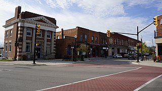
Cayuga is an unincorporated community and county seat of Haldimand County, Ontario, Canada located at the intersection of Highway 3 and Munsee Street and along the Grand River. Cayuga is about a 20-minute drive from Lake Erie and 30 minutes south of Hamilton and 115 minutes south of Toronto and consequently it has some cottages and recreational properties in the area. In the past, there was some light industry. It has the local district detachment for the Ontario Provincial Police. It is also uniquely located among larger communities on both the American and Canadian sides of the border boasting television reception from Toronto, Buffalo, New York, Hamilton, Kitchener and Erie, Pennsylvania.

<span class="mw-page-title-main">Mackenzie, British Columbia</span> District municipality in British Columbia, Canada

Mackenzie is a district municipality within the Fraser-Fort George Regional District in central British Columbia, Canada. The community is located at the south end of Williston Lake. The townsite, established by Alexandra Forest Industries and Cattermole Timber, was named for Sir Alexander MacKenzie (1764–1820).

<span class="mw-page-title-main">Alnwick/Haldimand</span> Township in Ontario, Canada

The Township of Alnwick/Haldimand is a township in central Ontario, Canada, in Northumberland County, situated between Lake Ontario and Rice Lake. It was formed in 2001 by the merger of Alnwick Township in the north and Haldimand Township in the south. Alderville First Nation is an autonomously governed First Nation contained within the township boundaries, in two non-contiguous sections along County Roads 45 and 18.

<span class="mw-page-title-main">Jarvis, Ontario</span> Community in Haldimand County, Ontario, Canada

Jarvis is a small community in Haldimand County, Ontario, Canada.

<span class="mw-page-title-main">Warman, Saskatchewan</span> City in Saskatchewan, Canada

Warman (/ˈwɔrmən/) is the ninth-largest city in the province of Saskatchewan, Canada. It is located approximately 20 kilometres (12 mi) north of the city of Saskatoon, and 5 kilometres (3.1 mi) northeast of the city of Martensville. According to the 2021 census, Warman is the fastest growing municipality in Saskatchewan, and was the fastest growing municipality in Canada between 2011 and 2016. Warman is a bedroom community of Saskatoon. The current mayor is Gary Philipchuk.

References

  1. "Shelley Ann Bentley". Haldimand County. Retrieved 15 March 2023.
  2. Hatch, F. J. (1983). The Aerodrome of Democracy: Canada and the British Commonwealth Air Training Plan, 1939-1945. Ottawa: Directorate of History, Department of National Defence. ISBN   0660114437.
  3. "Record". 20 July 2017.
  4. Forsyth, Bruce (1998). "A Short History of Abandoned and Downsized Canadian Military Bases". Military Bruce Historical Writings by Bruce Forsyth. Archived from the original on 4 September 2013. Retrieved 24 August 2013.
  5. Anon (2009). "Abandoned Aerodromes". Canada Flight Supplement Effective 0901Z 12 MArch 2009 To 0901Z 7 May 2009. Ottawa: Nav Canada. p. A35.
  6. Sonnenberg, Monte (4 December 2009). "Hagersville Tire Fire Fallout". Brantford Expositor. Retrieved 1 October 2015.
  7. Schneider, Keith; Times, Special To the New York (2 March 1990). "Worst Tire Inferno Has Put Focus on Disposal Problem". The New York Times.
  8. "Fire Threatens Disaster in Canada : Environment: Thousands of burning tires could produce tons of oil laden with toxic chemicals". Los Angeles Times. 21 February 1990.
  9. Nolan, Daniel (12 February 2015). "25 years ago today: The Hagersville tire fire that burned 17 days". TheRecord.com.
  10. Environment Canada Canadian Climate Normals 1971–2000, accessed 30 April 2010
  11. Government of Canada, Statistics Canada (1 February 2023). "Census Profile, 2021 Census - Hagersville [Population centre], Ontario and Ontario [Province]". www12.statcan.gc.ca. Retrieved 3 August 2023.
  12. 1 2 Government of Canada, Statistics Canada (8 February 2017). "Census Profile, 2016 Census - Hagersville [Population centre], Ontario and Ontario [Province]". www12.statcan.gc.ca. Retrieved 23 January 2019.
  13. "2021 Community Profiles". 2021 Canadian Census . Statistics Canada. 4 February 2022.
  14. "2016 Community Profiles". 2016 Canadian Census . Statistics Canada. 12 August 2021.
  15. "2006 Community Profiles". 2006 Canadian Census . Statistics Canada. 20 August 2019.
  16. "2001 Community Profiles". 2001 Canadian Census . Statistics Canada. 18 July 2021.
  17. 1 2 3 "Census Profile: Hagersville Ontario (Population centre)". Canada 2021 Census . Statistics Canada . Retrieved 11 August 2023.
  18. "Census Profile: Hagersville Ontario (Population centre)". Canada 2016 Census . Statistics Canada . Retrieved 11 August 2023.
  19. "Official web site: Neil Peart" . Retrieved 10 December 2007.