Halifax River

Last updated
Halifax River
HalifaxRiverSouthbound0890.JPG
A view of the Halifax River southbound from the Seabreeze Bridge, Daytona Beach, Volusia County, Florida. Three other bridges can be seen from this vista: Main Street Bridge (closest), Broadway Bridge, and Veterans Memorial Bridge. Two boat marinas can be seen to the right.
Halifaxrivermap fl.png
Halifax River Drainage Basin
EtymologyGeorge Montagu-Dunk, 2nd Earl of Halifax
Location
Country United States
State Florida
Cities Ormond Beach, FL, Holly Hill, FL, Daytona Beach, FL, South Daytona, FL, Port Orange, FL
Physical characteristics
SourceTomoka Basin
  location Tomoka State Park, Volusia County, FL
  coordinates 29°21′40″N81°05′30″W / 29.36111°N 81.09167°W / 29.36111; -81.09167
  elevation5 ft (1.5 m)
Mouth Atlantic Ocean
  location
Ponce Inlet, Volusia County, FL
  coordinates
29°04′25″N80°55′22″W / 29.07361°N 80.92278°W / 29.07361; -80.92278
  elevation
0 ft (0 m)
Length25 mi (40 km)
Basin size1,009 sq mi (2,610 km2)
Discharge 
  location Ponce Inlet, FL
Basin features
Tributaries 
  leftHalifax Creek
  right Tomoka River, Spruce Creek

The Halifax River is part of the Atlantic Intracoastal Waterway, located in northeast Volusia County, Florida. The waterway was originally known as the North Mosquito River, but was renamed after George Montagu-Dunk, 2nd Earl of Halifax (for whom Halifax, Nova Scotia, Canada is also named), during the British occupation of Florida (1763–1784). [1] [2]

Contents

Geography

The Halifax River originates at Tomoka Bay, at the confluence of the Tomoka River, Bulow Creek, and Halifax Creek, adjoining Tomoka State Park. The Halifax River's drainage basin (or catchment) includes most of eastern Volusia County, which includes the flow from the Tomoka River and Halifax Creek. The total area covered is 1008.3 km². [3] Water flows south for a distance of 25 miles (40 km). The Halifax River merges with Spruce Creek and the Mosquito Lagoon just before it connects to the Atlantic Ocean via the Ponce de Leon Inlet.

The Halifax River runs through the cities of Ormond Beach, and Daytona Beach. It also runs next to the Jackie Robinson Ballpark on City Island and the Ponce de Leon Inlet Lighthouse. The Halifax Harbor Marina is located on the waterway as well.

Cities along the river

The Halifax River runs through two cities, and past four cities and one town, and was used to define portions of these cities' borders. The middle of the riverbed at the time the borders were established was the line to define the borders between cities. The cities below have either historic significance or cultural lore connecting them to the Halifax River. They are ordered from the beginning of the river to its end.

Bridges

There are currently six bridges along the river, including one bascule bridge. They are ordered from north to south.

History

Native Americans

The area of the Halifax River was first settled about 7,000 years ago, by Native American tribes who were the ancestors of tribes such as the Timucua Indians. The natives lived on fish and oysters, leaving shell mounds on both sides of the Halifax River. Most of the shell mounds were used by later settlers to build roads, but a few remain in the area, preserved as historical sites, such as Green Mound, Nocoroco, Ormond Mound, and Spruce Creek Mound Complex. The natives were likely part of the St. Johns culture.

European exploration

First Spanish occupation 1513-1763

After Juan Ponce de León claimed Florida in April 1513, and Pedro Menéndez de Avilés established St. Augustine in 1565, the Spanish continued to explore the region. In 1569 Captain Antonio de Prado first explored the area around Ponce de Leon Inlet (which he named los Mosquitos, due to the large number of gnats that inhabited the area), and mentioned Nocoroco in his report to the King of Spain, noting that the village was located between two rivers (now known as Tomoka and Halifax). In 1605, Spanish explorer Alvaro Mexia visited and mapped the Halifax River area (named North Mosquito River on his map), noting the native villages of Nocoroco, Cacaroy, Cicale, and Caparaca in his report. [9] [10]

The Spanish brought in Franciscan friars and established Catholic Missions in Florida, in an attempt to convert the natives to Christianity. At their peak, there were 44 such Spanish missions in Florida, and some of them may have been in the Halifax River area. The Spanish also recruited the natives to grow food on primitive farms. However, epidemics of yellow fever in 1649, smallpox in 1650, and measles in 1659 decimated both the Indian and Spanish population in Florida. Several Indian revolts also decimated the population further. By the time Spain ceded Florida to the British in 1763, they had little progress to show for their efforts in the colony and Florida was left as a "hollow shell", practically devoid of population when the Spanish evacuated. [10]

British occupation 1763-1783

Spain ceded Florida to the British in 1763, in exchange for Cuba, at the end of the Seven Years' War/French and Indian War. Britain then divided the territory into East Florida and West Florida, and gave out many land grants to encourage settlers. During the survey of these land grants, the Halifax River received its name in honor of Lord Halifax, who was the British President of the Board of Trade. The British Council of East Florida made 576 grants on family right totaling more than 210,000 acres (850 km2), and 114 grants, totaling 1,443,000 acres (5,840 km2), by the approval of the King. After the American Revolution began, Florida became the destination for loyalists from the southern colonies, who were offered land free of taxes or levies for ten years. Colonists that settled in the Halifax River area named their colony Halifax City, which was located near present-day Allandale in Port Orange. [11] [12]

It was during the British occupation when Dr. Andrew Turnbull created the notorious New Smyrna colony, just to the south of the Halifax River, in 1768. The New Smyrna colonists complained about mistreatment during their indentured servitude, and the British Governor in St. Augustine eventually allowed them to leave.

Second Spanish occupation 1783-1821

The Spanish joined with the French on the Colonial side, against the British during the American Revolution. After the British loss, they surrendered Florida to Spain in exchange for the Bahamas in the Treaty of Paris (1783). According to the terms of the treaty, the British were obligated to evacuate their colonial subjects; however, Spain allowed any colonists to stay, provided they agreed to swear allegiance to the Spanish Kingdom and convert to Catholicism.

During this occupation period, the Spanish made three large land grants in the Halifax River area, one of which went to James Ormond, a Scottish sea captain, namesake of Ormond Beach, Florida. Ormond transported Franciscan friars to Florida for the Spanish, who gave him the 2,000-acre (8.1 km2) grant in 1807 as compensation. Two other Spanish land grants (roughly encompassing Daytona Beach and Port Orange) went to absentee landlords, and the areas remained undeveloped.

Recreation

Boating

Boating is a popular activity, and there are several marinas and yacht clubs located throughout the Halifax River. The Halifax River Yacht Club was founded in 1896. [13]

Fishing

Fishing is another popular activity in the Halifax River. Fishing is allowed from boats, the banks of the river, or from any of the bridges crossing the waterway. Some of the species that can be found include: trout, catfish, flounder, sheepshead, tarpon, snook, black drum, mangrove snapper and red drum. [14]

Wildlife Viewing

The Halifax river supports a diverse community of waterfowl, wading birds, fish, and other wildlife. The river and several of its tributaries (Tomoka River, Strickland, Thomson and Dodson Creek) are designated as a Manatee Sanctuary. Other rare species that inhabit the river basin include the wood stork, bald eagle, and Atlantic salt marsh snake. Numerous other birds can be viewed in the general area of the Halifax River Basin.

The Halifax River Trail forms part of the East Coast Greenway, a system of trails connecting Maine to Florida.

Intracoastal Waterway

Prior to 1913, navigation channels and canals in Florida were maintained chiefly by private enterprise. [15] In 1882 the Florida East Coast Line Canal and Transportation Co. was organized to develop a waterway from Jacksonville to Biscayne Bay by connecting with canals the St Johns, Matanzas, and Halifax rivers, Mosquito Lagoon, Indian river, Lake Worth, Hillsboro river, New river, and Snake Creek; in 1908 this vast undertaking was completed. [15]

The Rivers and Harbors Act of 1927, passed by Congress, authorized the Atlantic Intracoastal Waterway, using the route planned out by the Jacksonville District of the U.S. Army Corps Of Engineers. The Waterway was valuable during World War II, after German submarines sank numerous merchant ships off the East Coast. The Corps continues to maintain the navigation channel today, conducting dredgings as needed. [16]

See also

Related Research Articles

<span class="mw-page-title-main">Volusia County, Florida</span> County in Florida, United States

Volusia County is located in the east-central part of the U.S. state of Florida between the St. Johns River and the Atlantic Ocean. As of the 2020 census, the county was home to 553,543 people, an increase of 11.9% from the 2010 census. It was founded on December 29, 1854, from part of Orange County, and was named for the community of Volusia, located in northwestern Volusia County. Its first county seat was Enterprise. Since 1887, its county seat has been DeLand.

<span class="mw-page-title-main">Daytona Beach, Florida</span> City in Florida, United States

Daytona Beach, or simply Daytona, is a coastal resort city in Volusia County, Florida, United States. Located on the East Coast of the United States, its population was 72,647 at the 2020 census. It is part of the Deltona–Daytona Beach–Ormond Beach metropolitan area, and is a principal city of the Fun Coast region of Florida.

<span class="mw-page-title-main">Ormond Beach, Florida</span> City in Volusia County, Florida, US

Ormond Beach is a city in Volusia County, Florida, United States. The population was 43,080 at the 2020 census. Ormond Beach lies directly north of Daytona Beach and is a principal city of the Deltona–Daytona Beach–Ormond Beach, FL Metropolitan Statistical Area. The city is known as the birthplace of speed, as early adopters of motorized cars flocked to its hard-packed beaches for yearlong entertainment, since paved roads were not yet commonplace. Ormond Beach lies in Central Eastern Florida.

<span class="mw-page-title-main">Ormond-by-the-Sea, Florida</span> CDP in Florida, United States

Ormond-by-the-Sea is a census-designated place and an unincorporated town in Volusia County, Florida, United States. The population was 7,312 as of the 2020 census, a decrease from 7,406 in the 2010 census.

<span class="mw-page-title-main">Port Orange, Florida</span> City in Florida, United States

Port Orange is a city in Volusia County, Florida. The city's population was estimated at 64,842 in 2019 by the U.S. Census Bureau.

<span class="mw-page-title-main">Broadway Bridge (Daytona Beach)</span> Bridge in Daytona Beach, Florida, US

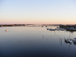
The Broadway Bridge is a segmental bridge that spans the Halifax River and Intracoastal Waterway in downtown Daytona Beach, Florida, carrying U.S. Route 92.

<span class="mw-page-title-main">Florida State Road 5A</span>

State Road 5A (SR 5A), also known as Nova Road, is a north–south highway that begins and ends at U.S. Highway 1 or US 1, in Port Orange and Ormond Beach, respectively. It is noted that when 5A was built, it was used more as a bypass or beltway, but in recent years with growth reaching far beyond SR 5A, it sees more use as a major thoroughfare that passes through the heart of the region.

<span class="mw-page-title-main">Florida State Road 441</span>

State Road 441 is a 5.4-mile-long (8.7 km) street in Port Orange, Daytona Beach Shores, and Daytona Beach. It is locally known as Peninsula Drive, and signed as a north–south road.

<span class="mw-page-title-main">Florida State Road 415</span>

State Road 415 is a north–south route in Central Florida running between State Road 44 in Volusia County and SR 46 in Seminole County.

<span class="mw-page-title-main">Florida State Road 40</span> Highway in Florida

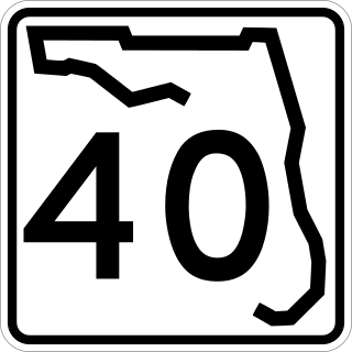
State Road 40 is a 91.8-mile-long (147.7 km) east–west highway across northern and east-central Florida, running from U.S. Highway 41 (US 41) in Rainbow Lakes Estates eastwards through Ocala over the Ocklawaha River and through the heart of the Ocala National Forest to SR A1A in Ormond Beach. Names of the road include Silver Springs Boulevard in Ocala, Fort Brooks Road from Silver Springs through Astor, Butler Road in Astor, and Granada Boulevard in Ormond Beach. Former sections in Ormond Beach are named "Old Tomoka Road" and "Old Tomoka Avenue."

<span class="mw-page-title-main">Tomoka State Park</span> State park in Florida, United States

Tomoka State Park is an 2,000-acre (8.1 km2) Florida State Park located along the Tomoka River, three miles (5 km) north of Ormond Beach on North Beach Street.

<span class="mw-page-title-main">Deltona–Daytona Beach–Ormond Beach, Florida Metropolitan Statistical Area</span> Metropolitan statistical area in Florida, United States

The Deltona–Daytona Beach–Ormond Beach, Florida Metropolitan Statistical Area is a metropolitan statistical area (MSA) in central and the north portions of Florida consisting of Volusia and Flagler counties in the state of Florida. As of 2013, it is the 88th-largest MSA in the United States, with a census-estimated population of 600,756.

<span class="mw-page-title-main">Tomoka River</span> River in Florida, United States of America

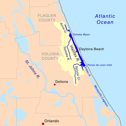
The Tomoka River is a north-flowing river in Volusia County, Florida, United States. It drains an area of about 110 square miles (280 km2) and has a length of 19.6 miles (31.5 km).

Volusia County Schools is the public school district for Volusia County, Florida, United States. The district serves the 16 cities of Daytona Beach, DeBary, DeLand, DeLeon Springs, Deltona, Edgewater, Enterprise, Holly Hill, Lake Helen, New Smyrna Beach, Oak Hill, Orange City, Ormond Beach, Osteen, Pierson, and Port Orange. It is the 57th largest school district in the United States and serves approximately 63,000 students. The district is composed of 45 elementary schools, 12 middle schools, and 9 high schools. In addition there are 9 alternative schools, 7 charter schools, 2 combination schools, and 1 district virtual instruction program. The district is accredited by the Southern Association of Colleges and Schools/AdvancED.

<span class="mw-page-title-main">Port Orange Causeway</span> Bridge in Florida, United States of America

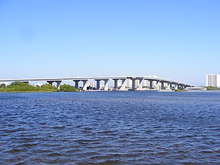
The Port Orange Causeway, commonly called the Port Orange Bridge or the Dunlawton Bridge, spans the Halifax River and Intracoastal Waterway in Port Orange, Volusia County, Florida. The bridge carries approximately 29,000 vehicles per day across four lanes of State Road A1A and Dunlawton Avenue.

<span class="mw-page-title-main">Granada Bridge (Ormond Beach)</span> Structure in Florida, United States

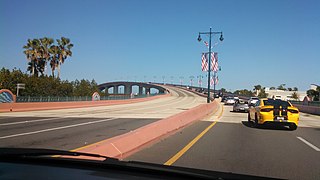
The Granada Bridge is a high-clearance bridge that spans the Halifax River and Intracoastal Waterway, linking the mainland and beach peninsula parts of Ormond Beach, Volusia County, Florida. Granada Bridge carries four lanes of State Road 40 and Granada Blvd. The Casements, along with City Hall Plaza, Fortunato Park, and Riverbridge Park reside at the four corners of Ormond Beach's Granada Bridge, which give their collective name to the annual "Four Corners Festival" in Ormond Beach.

Seabreeze is a beachside neighborhood in Daytona Beach, Florida, which existed as an independent city from May 24, 1901 until January 1, 1926, when it merged with Daytona and Daytona Beach to become one consolidated city.

<span class="mw-page-title-main">Ormond Scenic Loop and Trail</span>

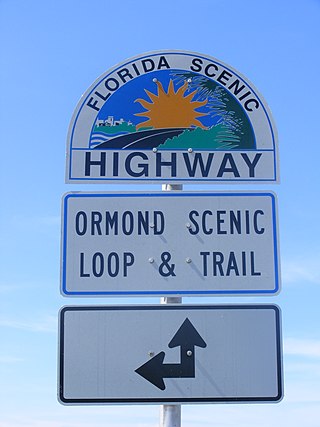
The Ormond Scenic Loop and Trail is a series of scenic state and county highways in Volusia County, Florida. CR 2002 is the northern leg of the trail. CR 4011(Old Dixie Highway and North Beach Street) is the western leg, with a spur onto Pine Tree Drive. SR 40(East Granada Boulevard) is the southern leg of the trail. CR 2803(John Anderson Drive) is the central leg of the trail, and SR A1A is the eastern leg of the trail. Florida Scenic Highway, designated this route on July 9, 2007.

<span class="mw-page-title-main">Veterans Memorial Bridge (Daytona Beach)</span> Bridge in Florida, United States of America

The Veterans Memorial Bridge, commonly called the Orange Avenue Bridge, spans the Halifax River and Intracoastal Waterway in Daytona Beach, Florida, Volusia County, Florida. The bridge carries vehicles across two lanes of CR 4050 from Orange Avenue and Silver Beach Avenue.

<span class="mw-page-title-main">Mosquito Roarers</span> Florida militia active across Central Florida during the Second Seminole War

The Mosquito Roarers were a Florida militia consisting of residents working in or near many of the sugar plantations of coastal Mosquito County, from present-day Hillsborourgh County to Volusia County. Called into service during the Fall of 1835, the militia became Company B of the Florida militia. They were involved in battles against the Seminole people.

References

  1. "Hometown News: East Volusia has rich history". Archived from the original on 2010-06-12. Retrieved 2008-11-19.
  2. "The Montague Millennium: George Montagu Dunk, 1716-1771". Archived from the original on 2008-12-18. Retrieved 2008-11-20.
  3. "Halifax River Watershed Facts". St. Johns River Water Management District. Retrieved 2008-11-17.[ dead link ]
  4. Ormond Beach Historical Trail
  5. Gold, Pleasant Daniel (1927). History of Volusia County, Florida. DeLand, FL: The E. O. Painter Printing Co.
  6. Fifth International Bridge Engineering Conference: Tampa, Florida April 3–5 - Page 31 by National Research Council (U.S.). Transportation Research Board - Bridges - 2000
  7. "Home". veteransmemorialbridge.com.
  8. Cardwell, Harold and Priscilla (2000). Images of America: Port Orange. Arcadia Publishing. ISBN   0-7385-0618-4.
  9. Haunted Daytona Beach: A Ghostly Tour of the World's Most Famous Beach by Dusty Smith (2007)
  10. 1 2 An Environmental History of Northeast Florida By James J. Miller (1998)
  11. Loyalists in East Florida 1774-1785, Wilbur H. Siebert , DeLand Florida (1929)
  12. Florida Place Names: Alachua to Zolfo Springs, Allen Morris, (1995)
  13. Gaby, Donald C. (2003): Heaven on the Halifax : a short history of the Halifax River Yacht Club, 1896-2003 (New Baskerville, Fla.: Halifax River Yacht Club, 2003)
  14. Daytona Beach News Journal Online: Fishing Report Archived 2008-12-22 at the Wayback Machine
  15. 1 2 Wikisource-logo.svg One or more of the preceding sentences incorporates text from a publication now in the public domain :  Chisholm, Hugh, ed. (1911). "Florida". Encyclopædia Britannica . Vol. 10 (11th ed.). Cambridge University Press. p. 542.
  16. "Jacksonville District, Setting the Pace" (PDF). U.S. Army Corps of Engineers. Archived from the original (PDF) on 2011-07-22. Retrieved 2010-08-07.