Halsua

Last updated
Halsua
Halso
Municipality
Halsuan kunta
Halso kommun
Halsua municipal office 20190703.jpg
Halsua municipal office
Halsua.vaakuna.svg
Halsua sijainti Suomi.svg
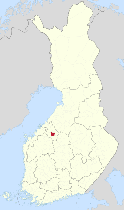
Location of Halsua in Finland
Coordinates: 63°27.8′N024°10′E / 63.4633°N 24.167°E / 63.4633; 24.167
CountryFlag of Finland.svg  Finland
Region Central Ostrobothnia
Sub-region Kaustinen sub-region
Charter 1868
Government
  Municipal managerKalevi Lindfors
Area
 (2018-01-01) [1]
  Total428.34 km2 (165.38 sq mi)
  Land413.01 km2 (159.46 sq mi)
  Water15.63 km2 (6.03 sq mi)
  Rank 201st largest in Finland
Population
 (2023-12-31) [2]
  Total1,013
  Rank 293rd largest in Finland
  Density2.45/km2 (6.3/sq mi)
Population by native language
[3]
   Finnish 95.2% (official)
   Swedish 0.6%
  Others4.3%
Population by age
[4]
  0 to 1413.3%
  15 to 6452%
  65 or older34.6%
Time zone UTC+02:00 (EET)
  Summer (DST) UTC+03:00 (EEST)
Website www.halsua.fi

Halsua (Swedish : Halso) is a municipality of Finland.

Contents

Halsua is located in the province of Western Finland and is part of the Central Ostrobothnia region. The municipality has a population of about 1200 in 2019's and covers an area of 428.34 square kilometres (165.38 sq mi) of which 15.63 km2 (6.03 sq mi) is water. [1] The population density is 2.45 inhabitants per square kilometre (6.3/sq mi).

Neighbouring municipalities are Kaustinen, Kokkola, Lestijärvi, Perho and Veteli.

The municipality is unilingually Finnish.

See also

Related Research Articles

<span class="mw-page-title-main">Evijärvi</span> Municipality in Southern Ostrobothnia, Finland

Evijärvi is a municipality of Finland. It is located in the Southern Ostrobothnia region. The municipality has a population of 2,297 and covers an area of 390.71 square kilometres (150.85 sq mi) of which 36.7 km2 (14.2 sq mi) is water. The population density is 6.49 inhabitants per square kilometre (16.8/sq mi).

<span class="mw-page-title-main">Juupajoki</span> Municipality in Pirkanmaa, Finland

Juupajoki is a municipality of Finland. It is located in the Pirkanmaa region. The municipality has a population of 1,708, which makes it the smallest municipality in Pirkanmaa in terms of population. It covers an area of 274.95 square kilometres (106.16 sq mi) of which 16.47 km2 (6.36 sq mi) is water. The population density is 6.61 inhabitants per square kilometre (17.1/sq mi). Korkeakoski is the administrative center of the municipality.

<span class="mw-page-title-main">Kaustinen</span> Municipality in Central Ostrobothnia, Finland

Kaustinen is a municipality of Finland. It is part of the Central Ostrobothnia region. The municipality has a population about 4300 and covers an area of 361.12 square kilometres (139.43 sq mi) of which 7.09 km2 (2.74 sq mi) is water. The population density is 11.68 inhabitants per square kilometre (30.3/sq mi).

<span class="mw-page-title-main">Kiuruvesi</span> Town in Northern Savonia, Finland

Kiuruvesi is a town and municipality of Finland located in the Northern Savonia region. The municipality has a population of 7,475 and covers an area of 1,422.90 square kilometres (549.38 sq mi) of which 94.79 km2 (36.60 sq mi) is water. The population density is 5.63 inhabitants per square kilometre (14.6/sq mi). Neighbour municipalities are Iisalmi, Pielavesi, Pyhäjärvi, Pyhäntä and Vieremä. The municipality is unilingually Finnish.

<span class="mw-page-title-main">Kronoby</span> Municipality in Ostrobothnia, Finland

Kronoby is a municipality of Finland. It is located in the province of Western Finland and is part of the Ostrobothnia region. The municipality has a population of 6,366 and covers an area of 752.65 square kilometres (290.60 sq mi) of which 40.3 km2 (15.6 sq mi) is water. The population density is 8.93 inhabitants per square kilometre (23.1/sq mi). The municipality is bilingual, with the majority speaking Swedish (76.5%) and the minority Finnish (19.2%).

<span class="mw-page-title-main">Lapinlahti</span> Municipality in Northern Savonia, Finland

Lapinlahti is a municipality of Finland. It is part of the Northern Savonia region, located 59 kilometres (37 mi) north of the city of Kuopio. The municipality has a population of 8,972 and covers an area of 1,245.16 square kilometres (480.76 sq mi) of which 148.58 km2 (57.37 sq mi) is water. The population density is 8.18 inhabitants per square kilometre (21.2/sq mi). The municipality is unilingually Finnish.

<span class="mw-page-title-main">Lappajärvi</span> Municipality in Southern Ostrobothnia, Finland

Lappajärvi is a municipality in Finland in Southern Ostrobothnia region. It is 78 kilometres (48 mi) from Lappajärvi to Seinäjoki, 80 kilometres (50 mi) to Kokkola and 117 kilometres (73 mi) to Vaasa. The municipality has a population of 2,789 and covers an area of 522.98 square kilometres (201.92 sq mi) of which 102.89 km2 (39.73 sq mi) is water. The population density is 6.63 inhabitants per square kilometre (17.2/sq mi).

<span class="mw-page-title-main">Lieto</span> City in Southwest Finland, Finland

Lieto is a city and municipality of Finland.

<span class="mw-page-title-main">Mynämäki</span> Municipality in Southwest Finland, Finland

Mynämäki is a municipality of Finland located in the Southwest Finland region. Neighbouring municipalities are Aura, Eura, Laitila, Masku, Nousiainen, Pöytyä, Rusko, Taivassalo, Turku and Vehmaa.

<span class="mw-page-title-main">Perho</span> Municipality in Central Ostrobothnia, Finland

Perho is a municipality of Finland. It is located in the province of Western Finland and is part of the Central Ostrobothnia region. The distance between Perho and the regional center Kokkola is about 100 kilometres (62 mi). The municipality has a population of 2,578 and covers an area of 775.19 square kilometres (299.30 sq mi) of which 27.25 km2 (10.52 sq mi) is water. The population density is 3.45 inhabitants per square kilometre (8.9/sq mi).

<span class="mw-page-title-main">Pomarkku</span> Municipality in Satakunta, Finland

Pomarkku is a municipality of Finland.

<span class="mw-page-title-main">Pyhäntä</span> Municipality in North Ostrobothnia, Finland

Pyhäntä is a municipality of Finland. It is located in the Northern Ostrobothnia region. The municipality has a population of 1,646 (31 December 2023) and covers an area of 847.48 square kilometres (327.21 sq mi) of which 36.72 km2 (14.18 sq mi) is water. The population density is 2.03 inhabitants per square kilometre (5.3/sq mi). The municipality is unilingually Finnish.

<span class="mw-page-title-main">Pyhäranta</span> Municipality in Southwest Finland, Finland

Pyhäranta is a municipality of Finland. It is located in the province of Western Finland and is part of the Southwest Finland region. The municipality has a population of 1,927 and covers an area of 291.75 square kilometres (112.65 sq mi) of which 148.5 km2 (57.3 sq mi) is water. The population density is 13.43 inhabitants per square kilometre (34.8/sq mi).

<span class="mw-page-title-main">Ristijärvi</span> Municipality in Kainuu, Finland

Ristijärvi is a municipality of Finland.

<span class="mw-page-title-main">Rusko</span> Municipality in Southwest Finland, Finland

Rusko is a municipality of Finland.

<span class="mw-page-title-main">Siikainen</span> Municipality in Satakunta, Finland

Siikainen is a municipality of Finland.

<span class="mw-page-title-main">Siikajoki</span> Municipality in North Ostrobothnia, Finland

Siikajoki is a municipality of Finland. It is part of the North Ostrobothnia region. The municipality has a population of 4,838 (31 December 2023) and covers an area of 1,653.89 square kilometres (638.57 sq mi) of which 601.94 km2 (232.41 sq mi) is water. The population density is 4.58 inhabitants per square kilometre (11.9/sq mi). Neighbour municipalities are Hailuoto, Liminka, Lumijoki, Raahe and Siikalatva.

<span class="mw-page-title-main">Utajärvi</span> Municipality in North Ostrobothnia, Finland

Utajärvi is a municipality of Finland. It is located in the Northern Ostrobothnia region next to the border of the Kainuu region, and is part of the former province of Oulu. It is 58 kilometres (36 mi) from Utajärvi to Oulu and 125 kilometres (78 mi) to Kajaani. The municipality has a population of 2,492 (31 December 2023) and covers an area of 1,736.73 square kilometres (670.56 sq mi) of which 65.55 km2 (25.31 sq mi) is water. The population density is 1.49 inhabitants per square kilometre (3.9/sq mi). The municipality is unilingually Finnish.

<span class="mw-page-title-main">Veteli</span> Municipality in Central Ostrobothnia, Finland

Veteli is a municipality of Finland.

<span class="mw-page-title-main">Akaa</span> Town in Pirkanmaa, Finland

Akaa is a town and a municipality in Pirkanmaa, Finland. It was created on January 1, 2007 when the town of Toijala and the municipality of Viiala were united into a single town. The municipality of Kylmäkoski was consolidated with Akaa on 1 January 2011.

References

  1. 1 2 "Area of Finnish Municipalities 1.1.2018" (PDF). National Land Survey of Finland. Retrieved 30 January 2018.
  2. "Immigration record high in Finland in 2023". StatFin. Statistics Finland . Retrieved 25 January 2024.
  3. "Demographic Structure by area as of 31 December 2022". Statistics Finland's PX-Web databases. Statistics Finland. Retrieved 6 September 2023.
  4. "Population according to age (1-year) and sex by area and the regional division of each statistical reference year, 2003–2020". StatFin. Statistics Finland . Retrieved 2 May 2021.

Commons-logo.svg Media related to Halsua at Wikimedia Commons