Hambleden Mill

Last updated

Hambleden Mill
Hambleden Mill and Weir - geograph.org.uk - 536842.jpg
Hambleden Mill and Weir
Type Watermill
Location Hambleden
Coordinates 51°33′32″N0°52′11″W / 51.5588°N 0.8698°W / 51.5588; -0.8698 Coordinates: 51°33′32″N0°52′11″W / 51.5588°N 0.8698°W / 51.5588; -0.8698
OS grid reference SU 78447 85042
Area Buckinghamshire
BuiltLate 18th century
Architectural style(s) Georgian
Listed Building – Grade II
Official name1-10, Hambleden Mill
Designated21 June 1955
Reference no.1310707
Buckinghamshire UK location map.svg
Red pog.svg
Location of Hambleden Mill in Buckinghamshire

Hambleden Mill is an historic watermill on the River Thames at Mill End, near the village of Hambleden in Buckinghamshire, England. It is linked by a footbridge to Hambleden Lock, which is on the Berkshire side of the river. It was Grade II listed [1] in 1955 and has now been converted into flats. Alongside the mill is Hambleden Marina which occupies two islands. Along the river frontage to the south-east is the site of a Roman Villa.

Contents

History

A mill at Hambleden is recorded in the Domesday Book of 1086, when it was held by Queen Matilda and had a rent of 20 shillings/year, as well as a fishery that yielded 1,000 eels annually. [2] Before 1235 the mill was granted to Keynsham Abbey. Alison Uttley described it as "The most beautiful place in the whole length of the long Thames valley." [3] The oldest part of the present mill building was built in the late 18th century, possibly incorporating part of an earlier 17th century mill. [4] This now forms the southern end of the building and has three main floors plus an attic, making it the tallest part of the building. This wing has half-hipped gables and plain tiles on the roof. A 19th century addition to the west, two stories high with a slate roof, stretches along the river front. [1]

In the late 19th century, a barge, Maid of the Mill, used to make a weekly journey with flour from the mill to Huntley & Palmers biscuit factory in Reading. On her return trip she carried broken biscuits for sale, cheap, to the local villagers. [5] The mill was still in use in the 1950s having been upgraded from the original waterwheel and grinding stones to a water-turbine driving steel rollers in about 1939. [3] It had fallen out of use by the early 1970s, and planning permission for conversion to apartments was granted in 1974. [4] The extensive renovations involved re-cladding in white shiplap boarding, and replacement of its many windows with 20th century casements, sashes and some horizontal sliding sashes in the 18th century attic windows. [1]

Next to the mill, away from the river, is Mill House, also a grade II listed building. This was built in around 1770, for use by the mill-owner, with flint walls and a rendered and whitewashed frontage. [6]

Locality

The mill is adjacent to a series of weirs which stretch across the River Thames, running diagonally across the river, to Hambleden Lock, which is on the western, Berkshire, bank of the river. The weir raises the upstream water level, which both provided the fast flow of water for the original watermill, and maintains a navigable depth of water above the weir. The lock raises or lowers boats travelling up and down the river past the weir. A footbridge follows the line of the weir right across the Thames, allowing pedestrian access between the path alongside Hambleden Mill and the Thames riverside path which runs in both directions on the Berkshire side of the river. [7] The area has been a popular visitor spot for many decades, with large numbers of postcards showing the mill, weir and lock [8] and a popular subject with artists. [9]

The two Hambleden Mill Islands lie in the river alongside the mill. The mill-stream that used to funnel water to the water-wheel on the front of the mill creates an island accessed via a bridge. And this, plus another island alongside it are now used by Hambleden Marina for Thames riverboat mooring facilities. [10]

To the south-east of the marina a Roman Villa site fronting on to the Thames was identified in 1921 from parchmarks in the grass during a dry summer. In the hot summer of 1975 enough detail of wall outlines appeared to enable a survey of the villa and its ancillary buildings and boundaries, including possible wharves and landing stages along the river frontage. The site was given legal protection as a scheduled monument in 1979. It is thought to be a subsidiary development from the nearby Yewdon Villa. [11]

Hambleden Mill and islands in the River Thames.

Conservation Area

The mill is within the Mill End, Hambleden Conservation Area, first designated in 1982. The conservation area includes both the hamlet of Mill End and the estate of Yewden Manor. The conservation area also falls within the Chiltern Hills Area of Outstanding Natural Beauty. [12]

See also

Related Research Articles

River Thames River in southern England

The River Thames, known alternatively in parts as the River Isis, is a river that flows through southern England including London. At 215 miles (346 km), it is the longest river entirely in England and the second-longest in the United Kingdom, after the River Severn.

Iffley Human settlement in England

Iffley is a village in a designated Conservation Area in Oxfordshire, England. It lies within the boundaries of the city of Oxford, between Cowley and the estates of Rose Hill and Donnington, and in proximity to the River Thames (Isis). A notable feature is its largely unchanged Norman church, St Mary the Virgin, which has a modern stained glass Nativity window designed by John Piper and another window designed by Roger Wagner. The church is a Grade I listed building.

Hambleden Human settlement in England

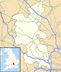
Hambleden is a small village and civil parish in south-west Buckinghamshire, England. The village is around 4 miles (6.4 km) west of Marlow, and around 3 miles (4.8 km) north-east of Henley-on-Thames in Oxfordshire.

Locks and weirs on the River Thames

The English River Thames is navigable from Cricklade or Lechlade to the sea, and this part of the river falls 71 meters (234 feet). There are 45 locks on the river, each with one or more adjacent weirs. These lock and weir combinations are used for controlling the flow of water down the river, most notably when there is a risk of flooding, and provide for navigation above the tideway.

River Blackwater (River Loddon) Tributary of the River Loddon in England

The River Blackwater is a tributary of the Loddon in England and sub-tributary of the Thames. It rises at two springs in Rowhill Nature Reserve between Aldershot, Hampshire and Farnham, Surrey. It curves a course north then west to join the Loddon in Swallowfield civil parish, central Berkshire. Part of the river splits Hampshire from Surrey; a smaller part does so as to Hampshire and Berkshire.

Teddington Lock Series of locks on the River Thames in London

Teddington Lock is a complex of three locks and a weir on the River Thames between Ham and Teddington in the London Borough of Richmond upon Thames, England. Historically in Middlesex, it was first built in 1810.

Caversham Lock Lock and weir on the River Thames in Berkshire, England

Caversham Lock is a lock and main weir on the River Thames in England at Reading, Berkshire. Both the lock and main weir are connected to De Bohun Island. The Thames Navigation Commissioners built the original lock in 1778. Additional sluices north of View Island and Heron Island form the whole weir complex. A footbridge passes over all three islands to connect Lower Caversham to Reading via a route other than George Street and Reading Bridge.

Cookham Lock Lock and weirs on the River Thames in Berkshire, England

Cookham Lock is a lock with weirs situated on the River Thames near Cookham, Berkshire, about a half-mile downstream of Cookham Bridge. The lock is set in a lock cut which is one of four streams here and it is surrounded by woods. On one side is Sashes Island and on the other is Mill Island connected to Formosa Island, the largest on the non-tidal Thames.

Thames Path National Trail following the River Thames in England

The Thames Path is a National Trail following the River Thames from its source near Kemble in Gloucestershire to the Thames Barrier at Charlton, south east London. It is about 184 miles (296 km) long. A path was first proposed in 1948 but it only opened in 1996.

Hambleden Lock Lock on the River Thames in Berkshire, England

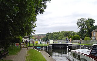
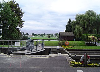
Hambleden Lock is a lock with a long weir situated on the River Thames in England, about 2 miles downstream of Henley Bridge. The lock is on the Berkshire bank between Aston and Remenham. Built by the Thames Navigation Commission in 1773, the lock is named after the village of Hambleden, a mile (1.5 km) to the north.

Mapledurham Watermill Historic site in Oxfordshire, England

Mapledurham Watermill is a historic watermill in the civil parish of Mapledurham in the English county of Oxfordshire. It is driven by the head of water created by Mapledurham Lock and Weir, on the River Thames. The mill was built in the 15th century, and further extended in the 17th, 18th and 19th centuries. It is a Grade II* listed building and is preserved in an operational state.

Osney Human settlement in England

Osney or Osney Island is a riverside community in the west of the city of Oxford, England. In modern times the name is applied to a community also known as Osney Town astride Botley Road, just west of the city's main railway station, on an island surrounded by the River Thames, Osney Ditch and another backwater connecting the Thames to Osney Ditch.

Temple Lock Lock and weir on the River Thames in Buckinghamshire, England

Temple Lock is a lock and weir situated on the Buckinghamshire bank of the River Thames near Temple Mill Island opposite Temple Meadows and not far from Hurley, Berkshire. It was first built by the Thames Navigation Commissioners in 1773.

Penton Hook Lock Lock on the River Thames in Surrey, England

Penton Hook Lock is the sixth lowest lock of forty four on the non-tidal reaches of the River Thames in England. It faces an island which was until its construction a pronounced meander and is on the site of its seasonal cutoff. It is against the left bank marking the church parish medieval border of Laleham and Staines upon Thames in Surrey for many centuries. Until 1965 their county was Middlesex. At 266 ft (81 m) it is the third longest lock on the river.

Boveney Lock Lock on the River Thames in Buckinghamshire, England

Boveney Lock is a lock on the River Thames situated on the Buckinghamshire bank opposite the Windsor Racecourse and close to Eton Wick. Boveney is a village a little way upstream on the same side. The lock was first built in 1838 by the Thames Navigation Commission. The lock was rebuilt in 1898 closer to the Buckinghamshire bank, and a set of boat rollers were installed on the old site.

Hurley Lock Lock and weir on the River Thames in Berkshire, England

Hurley Lock is a lock and weir on the River Thames in England, situated in a clump of wooded islands close to the village of Hurley, Berkshire. The lock was first built by the Thames Navigation Commissioners in 1773.

Osney Lock Lock on the River Thames in Oxfordshire, England

Osney Lock is a lock on the River Thames in Oxford, England, where the village or island of Osney is next to the river.

Clewer Mill Stream Stream in Berkshire, England

Clewer Mill Stream is a narrow twisting backwater of the River Thames near Windsor, Berkshire, England, which leaves the main river at Bush Ait and rejoins just above Queen Elizabeth Bridge. It is about 1.5 miles long. Clewer Mill Stream is named after the watermill that it once drove.

The Abbey River is a right-bank backwater of the River Thames in England, in Chertsey, Surrey — in the town's northern green and blue buffers. The L-shaped conduit adjoins mixed-use flood plain: water-meadows landscaped for a golf course, a motorway and a fresh water treatment works on the island it creates, Laleham Burway to its east and north in turn. Its offtake from the Thames is at the apex of Penton Hook, Staines upon Thames below its lower weir close to the Chertsey-Thorpe boundary in the Borough of Runnymede. Its outfall is the weir pool of Chertsey Lock back into the Thames, visible from Chertsey Bridge. The Environment Agency plans to build similar channels to the upstream Jubilee River, one of which will intersect the watercourse, another of which will be close to its outfall, thereby compensating for loss of its historic bypass functions.

References

  1. 1 2 3 Historic England. "Hambleden Mill, Hambleden (1310707)". National Heritage List for England . Retrieved 31 January 2018.
  2. Dr Ann Williams & Prof G H Martin, ed. (1992). Domesday Book: A complete translation. London: Penguin Books. p. 419.
  3. 1 2 Uttley, Alison (1950), Buckinghamshire, Hale
  4. 1 2 "Mill End Mill, Hambleden". Mills Archive. Retrieved 31 January 2018.
  5. "Memories of Hambleden". Buckinghamshire Family History Society. Retrieved 31 January 2018.
  6. Historic England. "Mill House, Hambleden (1332087)". National Heritage List for England . Retrieved 4 May 2020.
  7. "Hambleden Mill to Henley-on-Thames – a circular walk". National Trust. Retrieved 3 May 2020.
  8. "Mill End Mill, Hambleden". Mills Archive. Retrieved 4 May 2020.
  9. "Hambleden Lock". thames.me.uk. Retrieved 4 May 2020.
  10. "Hambleden Marina". hambledenmarina.co.uk. Retrieved 3 May 2020.
  11. Historic England (1996). "Roman villa at Mill End, Hambleden (1014601)". National Heritage List for England . Retrieved 4 May 2020.
  12. "Mill End Hambleden Conservation Area". Buckinghamshire Council: Wycombe Area. Retrieved 3 May 2020.