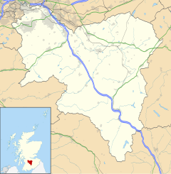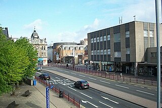
Hamilton is a large town in South Lanarkshire, Scotland. It serves as the main administrative centre of the South Lanarkshire council area. It sits 10 miles (16 km) south-east of Glasgow, 37 miles (60 km) south-west of Edinburgh and 74 miles (120 km) north of Carlisle. It is situated on the south bank of the River Clyde at its confluence with the Avon Water. Hamilton is the county town of the historic county of Lanarkshire and is the location of the headquarters of the modern local authority of South Lanarkshire.

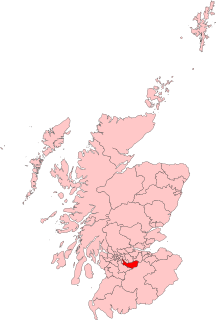
South Lanarkshire is one of 32 unitary authorities of Scotland. It borders the south-east of the City of Glasgow and contains some of Greater Glasgow's suburban towns, also containing many rural towns and villages. It also shares borders with Dumfries and Galloway, East Ayrshire, East Renfrewshire, North Lanarkshire, the Scottish Borders and West Lothian. It includes most of the historic county of Lanarkshire.

Lanarkshire, also called the County of Lanark, is an historic county, lieutenancy area and registration county in the central Lowlands of Scotland.

Rutherglen is a town in South Lanarkshire, Scotland, immediately south-east of the city of Glasgow – 3 miles (4.8 km) from its centre – and directly south of the River Clyde. Having existed as a Lanarkshire burgh in its own right for more than 800 years, in 1975 Rutherglen lost its own local council and administratively became a component of the City of Glasgow District Council within the Strathclyde region. In 1996 the towns were reallocated to the South Lanarkshire council area.

East Kilbride is the largest town in South Lanarkshire in Scotland and the country's 6th-largest city or town by population. It was also designated Scotland's first new town on 6 May 1947. The area lies on a raised plateau to the south of the Cathkin Braes, about 8 miles (13 km) south-east of Glasgow and close to the boundary with East Renfrewshire. East Kilbride is twinned with the town of Ballerup, in Denmark.

Cambuslang is a town on the south-eastern outskirts of Glasgow, Scotland. With approximately 30,000 residents, it is the 27th largest town in Scotland by population, although, never having had a town hall, it may also be considered the largest village in Scotland. It is within the local authority area of South Lanarkshire and directly borders the town of Rutherglen to the west. Historically, it was a large civil parish incorporating the nearby hamlets of Newton, Flemington, Westburn and Halfway.

The University of the West of Scotland, formerly the University of Paisley, is a public university with four campuses in south-western Scotland, in the towns of Paisley, Blantyre, Dumfries and Ayr, as well as a campus in London, England. The present institution dates from August 2007, following the merger of the University of Paisley with Bell College, Hamilton. It can trace its roots to the late 19th century, and has undergone numerous name changes and mergers over the last century, reflecting its gradual expansion throughout the west of Scotland region.

Blantyre is a town and civil parish in South Lanarkshire, Scotland, with a population of 16,900. It is bounded by the River Clyde to the north, the Rotten Calder to the west, the Park Burn to the east and the Rotten Burn to the south.

Uddingston is a small town in South Lanarkshire, Scotland. It is on the north side of the River Clyde, south-east of Glasgow city centre, and acts as a dormitory suburb for the city.
Burnbank is an area in the town of Hamilton, South Lanarkshire, Scotland. It was formerly a separate mining village before being absorbed into the town.
Lanark and Hamilton East is a county constituency of the House of Commons of the Parliament of the United Kingdom, which was first used at the 2005 general election. It covers parts of the former Clydesdale, Hamilton North and Bellshill and Hamilton South constituencies, and it elects one Member of Parliament (MP) by the first past the post voting system.

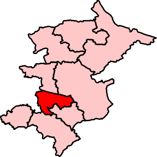
Rutherglen and Hamilton West is a burgh constituency of the House of Commons of the Parliament of the United Kingdom, which was created for the 2005 general election. It covers almost all of the former constituency of Glasgow Rutherglen and most of the former constituency of Hamilton South, and it elects one Member of Parliament (MP) by the first-past-the-post system of election. The current MP is Margaret Ferrier, an independent, who won the seat at the 2019 snap general election. She had previously held the seat from 2015 to 2017. Ferrier was previously a Scottish National Party MP until the whip was withdrawn on 1 October 2020 after an incident relating to a breach of the COVID-19 pandemic regulations.

East Kilbride, Strathaven and Lesmahagow is a county constituency of the House of Commons of the Parliament of the United Kingdom, which was first used in the general election of 2005. It replaced East Kilbride and some of Clydesdale, and it elects one Member of Parliament (MP) by the first past the post system of election.

Bell College was a higher education college based in Hamilton and Dumfries in Scotland. Founded in 1972, the College merged with the University of Paisley on 1 August 2007, it is now part of the renamed University of the West of Scotland.

Burnside is a mostly residential area in the town of Rutherglen in South Lanarkshire, Scotland. Including the neighbourhoods of High Burnside and High Crosshill, respectively south and north-west of its main street, it borders Overtoun Park in Rutherglen plus several other residential areas of the town, as well as western parts of neighbouring Cambuslang.

Earnock Estate is a residential area in Hamilton, South Lanarkshire, Scotland, which is located just east of High Earnock and south of Hillhouse. The area was developed in the 1960s and is home to some of the oldest buildings in the area.

Rutherglen is a constituency of the Scottish Parliament (Holyrood) covering part of the council area of South Lanarkshire. It elects one Member of the Scottish Parliament (MSP) by the plurality method of election. Also, it is one of nine constituencies in the Glasgow electoral region, which elects seven additional members, in addition to the nine constituency MSPs, to produce a form of proportional representation for the region as a whole.
Uddingston and Bellshill is a constituency of the Scottish Parliament (Holyrood) covering part of the council areas of North Lanarkshire and South Lanarkshire. It elects one Member of the Scottish Parliament (MSP) by the plurality method of election. Also, however, it is one of nine constituencies in the Central Scotland electoral region, which elects seven additional members, in addition to nine constituency MSPs, to produce a form of proportional representation for the region as a whole.

Newton is a mainly residential district in the town of Cambuslang in Scotland; it is situated directly south of the River Clyde. Newton is within the Cambuslang East ward of the South Lanarkshire Council area. Formerly a mining settlement from the mid-19th to mid-20th centuries then sparsely populated for several decades, in the early 2000s it was designated a 'Community Growth Area' for residential development with several hundred houses, a new primary school and associated infrastructure constructed in phases over several years into the 2020s, mostly on fields previously used by a farm which had operated for several centuries before closing around the turn of the 21st century.

The A724 road in Scotland runs within South Lanarkshire between Rutherglen and Hamilton. It follows an ancient route which is marked on William Roy's Lowland Map of Scotland (1755) with only minor deviations from its modern course.