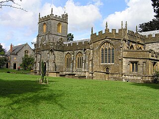
Hammet Street is a street in Taunton, Somerset, England, that runs between the Church of St Mary Magdalene and the town centre. It is named after Sir Benjamin Hammet, who had a bill passed through parliament to allow him to build the street in 1788. The street includes four listed buildings: numbers 4 and 5–8, 9–12, 13–17, and number 18 with 33 Fore Street. The first three buildings are grade II* listed, while the last is grade II listed, and together with the Church of St Mary Magdalene and the listed buildings in Church Square, the English Heritage consider them to "form an extremely important group."[1]
Sir Benjamin Hammet was born in Taunton around 1736, and was a Member of Parliament for the town from 1782 until his death in 1800.[2] In the late 1780s, a number of Acts of Parliament were passed to make improvement to town and city centres,[3] and Hammet carried such an Improvement Act for Taunton through in 1788. The Act allowed Hammet to purchase two houses on Fore Street, one occupied and the other empty, and demolish them to make way for the new road.[4] The road built ran directly towards the Church of St Mary Magdalene, which had previously been accessible only via a narrow lane. Hammet Street is 36 feet (11m) wide at its narrowest point, designed to allow carriages to travel to the church without endangering pedestrians. In his history of Taunton, Joshua Toulmin describes the terraces along Hammet Street as "handsome houses", and praises the way the street opened up the view of the church from the town centre.[4] The original houses remain, and the ground floors of many are currently used as estate agents.[5]
Listed buildings
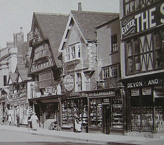
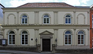
Number 8 with 4–7 to the left
Hammet Street has four listed building entries. On the north side, numbers 4–8 make up one entry, while on the south side, numbers 9–12 are considered one entry, number 13–17 another, and number 18 forms a separate entry, along with number 33 Fore Street. Both sides of the road are of similar design, consisting of the original eighteenth century three-storey terraces of brown brick, with each house separated by plain pilasters, and continuous eaves cornice. Each property has five sash windows in plain reveals. The roofs are a mix of tile and slate, and retain the original rainwater pipes. The door-cases of numbers 4–8 and 9–12 are of painted stone, with "half round Tuscan pilasters, open pediments and traceriedfanlights."[1][6] Numbers 13 and 17 have similar door-cases, but with semi-circular rather than traceried fanlights.[7] The majority of the doors have six panels, but numbers 8 and 9 have four, and number 10 has no panels. There is an archway between numbers 5 and 6. Numbers 5 and 9 have modern shop windows on the ground floor.[1] The east side of number 8 and 9 form the side of Church Square, and each have three windows facing into the square.[1][6] The entry for numbers 13–17 notes that those properties have been "considerably altered, especially on the ground floor," and have shop fronts dating from no later than the nineteenth century.[7] Number 18 is significantly different from the other listed buildings, having been colour washed, and the part of the building facing into Fore Street has been elevated.[8]
Taunton is a town in Somerset, England, with a 2011 population of 69,570. Its 1,000 years of history include a 10th-century monastery. Taunton Castle originated in the Anglo Saxon period and was later the site of a priory. The Normans built a stone castle that belonged to the Bishops of Winchester, of which the reconstructed parts are the inner ward, housing the Museum of Somerset and Somerset Military Museum. Events include the Second Cornish uprising of 1497, when Perkin Warbeck marched a 6,000-strong army to Taunton, most of which surrendered to Henry VII on 4 October 1497. On 20 June 1685 the Duke of Monmouth crowned himself King of England at Taunton in a rebellion that peaked with the Battle of Sedgemoor. Judge Jeffreys lived in the town during the Bloody Assizes in the Great Hall of the Castle. The Grand Western Canal reached Taunton in 1839 and the railway in 1842. Today it includes Musgrove Park Hospital, the Somerset County Cricket Club's County Ground and the headquarters of 40 Commando, Royal Marines. The Taunton flower show has been held in Vivary Park since 1866. The United Kingdom Hydrographic Office is in Admiralty Way.
North Petherton is a small town and civil parish in Somerset, England, situated on the edge of the eastern foothills of the Quantocks, and close to the edge of the Somerset Levels. The town has a population of 6,730. The parish includes Hamp, Melcombe, Shearston, Woolmersdon and Huntworth.
Chard is a town and a civil parish in the English county of Somerset. It lies on the A30 road near the Devon and Dorset borders, 15 miles (24 km) south west of Yeovil. The parish has a population of approximately 13,000 and, at an elevation of 121 metres (397 ft), Chard is the southernmost and one of the highest towns in Somerset. Administratively Chard forms part of the district of South Somerset.
Wellington is a small market town in rural Somerset, a county in the west of England, situated 7 miles (11 km) south west of Taunton in the Somerset West and Taunton district, near the border with Devon, which runs along the Blackdown Hills to the south of the town. The town has a population of 14,549, which includes the residents of the parish of Wellington Without, and the villages of Tone and Tonedale.
Langford Budville is a village and civil parish in Somerset, England, situated near the River Tone 2 miles (3.2 km) north-west of Wellington, 4.5 miles (7.2 km) from Wiveliscombe and 6 miles (9.7 km) west of Taunton in the Somerset West and Taunton district. The parish includes the hamlets of Bindon, Lower Chipley, Lower Wellisford, Ramsey and Runnington. The parish has a population of 535.
Brompton Regis is a village and civil parish in the Somerset West and Taunton district of Somerset, England about 5 miles (8.0 km) north-east of Dulverton. It is situated on the River Pulham in the Brendon Hills within the Exmoor National Park, close to Wimbleball Lake, a water supply reservoir constructed in the 1970s and completed in 1979. According to the 2011 census the village had a population of 449. The parish boundary is marked by the River Exe which is crossed by the medieval Chilly Bridge and Hele Bridge. The Haddeo is crossed by Bury Bridge.
The Nickels-Sortwell House is a historic house museum at 121 Main Street in Wiscasset, Maine, United States. Built in 1807 by a wealthy ship's captain, the house was designated a National Historic Landmark in 1970 as an exceptionally high-quality example of the Federal style of architecture. After serving as a hotel for much of the 19th century, the house returned to private hands in 1900. It was given to Historic New England in 1958, which gives tours of the house between May and October.
Taunton Castle is a castle built to defend the town of Taunton, Somerset, England. It has origins in the Anglo Saxon period and was later the site of a priory. The Normans then built a stone structured castle, which belonged to the Bishops of Winchester. The current heavily reconstructed buildings are the inner ward, which now houses the Museum of Somerset and the Somerset Military Museum. The building was designated a grade I listed building in 1952.
Taunton Deane is a local government district with borough status in the English county of Somerset. In the United Kingdom, the term listed building refers to a building or other structure officially designated as being of special architectural, historical or cultural significance; Grade I structures are those considered to be "buildings of exceptional interest". Listing was begun by a provision in the Town and Country Planning Act 1947. Once listed, severe restrictions are imposed on the modifications allowed to a building's structure or its fittings. In England, the authority for listing under the Planning Act 1990 rests with Historic England, a non-departmental public body sponsored by the Department for Digital, Culture, Media and Sport; local authorities have a responsibility to regulate and enforce the planning regulations.
St Mary Magdalen's Church is a Roman Catholic church in the Montpelier area of Brighton, part of the English city of Brighton and Hove. It is one of six Roman Catholic churches in Brighton and one of eleven in the city area. Built by ecclesiastical architect Gilbert Blount in a 13th-century Gothic style to serve the rapidly expanding residential area on the border of Brighton and Hove, it has been listed at Grade II by English Heritage in view of its architectural importance. An adjacent presbytery and parish hall have been listed separately at Grade II.
Gray's Almshouses is a terrace of almshouses in Taunton, Somerset, England, founded in 1635 by the wealthy cloth-merchant Robert Gray, whose monument survives in the Church of St Mary Magdalene. The building is one of the oldest surviving in Taunton and is one of the earliest brick buildings in the county. The Almshouses were designed to provide accommodation for six men and ten women and for a reader who was to act as chaplain and schoolmaster. It is a grade I listed building as designated by English Heritage. Following renovation in the late twentieth century it now comprises sheltered accommodation of nine flats for the elderly.
The Tudor Tavern at No 15 Fore Street, Taunton, Somerset, England has been designated as a Grade I listed building. Built in 1578, the house is three storeys high of a timber-frame construction, with jettied first and second floors. The frontage is of carved bressummers with interlocking curved braces, while the roof is red tiles. There is a medieval hall with an open trussed roof behind the front.
Regency Square is a large early 19th-century residential development on the seafront in Brighton, part of the British city of Brighton and Hove. Conceived by speculative developer Joshua Hanson as Brighton underwent its rapid transformation into a fashionable resort, the three-sided "set piece" of 69 houses and associated structures was built between 1818 and 1832. Most of the houses overlooking the central garden were complete by 1824. The site was previously known, briefly and unofficially, as Belle Vue Field.
Montpelier Crescent is a mid 19th-century crescent of 38 houses in the Montpelier suburb of Brighton, part of the English coastal city of Brighton and Hove. Built in five parts as a set-piece residential development in the rapidly growing seaside resort, the main part of the crescent was designed between 1843 and 1847 by prominent local architect Amon Henry Wilds and is one of his most distinctive compositions. Extra houses were added at both ends of the crescent in the mid-1850s. Unlike most other squares, terraces and crescents in Brighton, it does not face the sea—and the view it originally had towards the South Downs was blocked within a few years by a tall terrace of houses opposite. Montpelier was an exclusive and "salubrious" area of Brighton, and Montpelier Crescent has been called its "great showpiece". Wilds's central section has been protected as Grade II* listed, with the later additions listed separately at the lower Grade II. The crescent is in one of the city's 34 conservation areas, and forms one of several "outstanding examples of late Regency architecture" within it.
Taunton Deane is a local government district with borough status in the English county of Somerset. In the United Kingdom, the term listed building refers to a building or other structure officially designated as being of special architectural, historical or cultural significance; Grade II* structures are those considered to be "particularly significant buildings of more than local interest". Listing was begun by a provision in the Town and Country Planning Act 1947. Once listed, severe restrictions are imposed on the modifications allowed to a building's structure or its fittings. In England, the authority for listing under the Planning Act 1990 rests with Historic England, a non-departmental public body sponsored by the Department for Digital, Culture, Media and Sport; local authorities have a responsibility to regulate and enforce the planning regulations.
Christ Church is on Church Street, Adlington, Lancashire, England. It is a redundant Anglican church, and is recorded in the National Heritage List for England as a designated Grade II listed building.
Carey Baptist Church, is in Pole Street, Preston, Lancashire, England. It is recorded in the National Heritage List for England as a designated Grade II listed building.
Emmanuel Church is in Brook Street, Preston, Lancashire, England. It is in the deanery of Preston, the archdeaconry of Lancaster, and the diocese of Blackburn. The church is recorded in the National Heritage List for England as a designated Grade II listed building.
The Crescent is a street in Taunton, a town in the English county of Somerset. Construction began in 1807, during a period of extensive redevelopment in the town, driven by the Market House Society and the Member of Parliament Sir Benjamin Hammet. Lined on the eastern side by a Georgian terrace, the street follows a shallow crescent shape, broken in the middle by Crescent Way and a bit further south by St George's Place. It links Upper High Street, at its southern end, with Park Street and Tower Street to the north. On the western side, Somerset County Council have their offices in the County Hall, erected in 1935, and extended in the 1960s. The Georgian terrace, the Masonic Hall, and the County Hall are recorded in the National Heritage List for England as listed buildings.
Taunton Unitarian Chapel is on Mary Street, Taunton, Somerset, England. It was built in the early 18th century as a Baptist chapel, but later adopted Unitarianism. The exterior was extensively renovated in the 19th century in an Italianate style. The chapel has been designated as a Grade II* listed building.
This page is based on this Wikipedia article Text is available under the CC BY-SA 4.0 license; additional terms may apply. Images, videos and audio are available under their respective licenses.