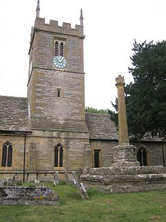
Wychavon is a local government district in Worcestershire, England. Its council is based in the town of Pershore, and the other towns in the district are Droitwich Spa and Evesham. The district extends from the south-east corner of Worcestershire north and west. It borders all the other districts of Worcestershire, as well as the counties of Gloucestershire and Warwickshire.

The Kennebecasis River is a tributary of the Saint John River in southern New Brunswick, Canada. The name Kennebecasis is thought to be derived from the Mi'kmaq "Kenepekachiachk", meaning "little long bay place." It runs for approximately 95 kilometres, draining an area in the Caledonia Highlands, an extension of the Appalachian Mountains, inland from the Bay of Fundy.
A reaction ferry is a cable ferry that uses the reaction of the current of a river against a fixed tether to propel the vessel across the water. Such ferries operate faster and more effectively in rivers with strong currents.

Mid Worcestershire is a constituency represented in the House of Commons of the UK Parliament since 2015 by Nigel Huddleston, a Conservative.

Twickenham is a constituency represented in the House of Commons of the UK Parliament since 2017 by Sir Vince Cable, the leader of the Liberal Democrats.

Transportation in the Commonwealth of Virginia is by land, sea and air. Virginia's extensive network of highways and railroads were developed and built over a period almost 400 years, beginning almost immediately after the founding of Jamestown in 1607, and often incorporating old established trails of the Native Americans.

Wisemans Ferry is a cable ferry across the Hawkesbury River in New South Wales, Australia. The ferry operates from the eponymous community of Wisemans Ferry on the south bank, to a point on the north bank downstream of the Hawkesbury River's confluence with the Macdonald River, connecting with the old Great North Road. The crossing has remained in use on its current site since 1829, making it the oldest ferry crossing still in operation in New South Wales, and possibly in Australia.
The Sans Souci Ferry is a cable ferry that provides access across the Cashie River in Bertie County, North Carolina. Since the 1930s, the ferry has been operated by the North Carolina Department of Transportation.
Eye Hill No. 382, Saskatchewan was established on December 12, 1910. It is a rural municipality in west-central Saskatchewan, Canada near the Alberta - Saskatchewan border. Eye Hill No. 382, Saskatchewan operates from Box 69, Macklin, SK S0L 2C0

Hampton Loade Ferry was a pedestrian cable ferry linking the villages of Hampton Loade and Hampton across the River Severn in the English county of Shropshire and providing a link to Hampton Loade village from Hampton Loade station on the heritage Severn Valley Railway, in Hampton village.

Hampton Ferry is a pedestrian and cycle ferry service across the River Thames in England.

Collinston is an unincorporated community on the northeastern edge of Box Elder County, Utah, United States.

The Needles Ferry is a cable ferry across Lower Arrow Lake in British Columbia, Canada. It is situated 59 kilometres (37 mi) south of Nakusp and links Needles and Fauquier.

The Laval-sur-le-Lac–Île-Bizard Ferry is a seasonal cable ferry crossing the city limits of Montreal in the Canadian province of Quebec. It carries cars, bicycles and pedestrians across the Rivière des Prairies from Laval-sur-le-Lac to Île Bizard.
The Clarkboro Ferry is a cable ferry in the Canadian province of Saskatchewan. The ferry crosses the South Saskatchewan River at Clark's Crossing, carrying Grid Road 784 across the river, and connecting Warman in the west and Aberdeen in the east. The ferry is named for the community of Clarkboro located southeast of the ferry's eastern terminal. The former town of Clarkboro was home to a section crew on the CNR, had a post office, a general store, a railroad siding, a water tower for steam locomotives and two grain elevators. Both Clarkboro and Clark's Crossing are named for John Fowler Clark, who homesteaded the area in 1882.

The Westerhüsen Ferry is a cable ferry across the Elbe river in the city of Magdeburg in Saxony-Anhalt, Germany. The ferry links the districts of Westerhüsen, on the left bank, and Randau-Calenberge opposite.

The Sandau Ferry, also known as the Sandau Büttnershof Ferry, is a cable ferry across the Elbe river between Sandau and Büttnershof in Saxony-Anhalt, Germany.


