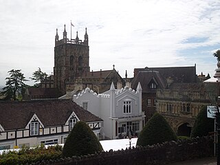
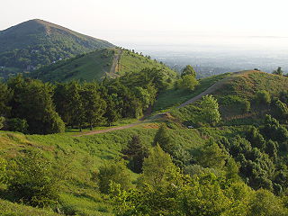
Malvern Hills is a local government district in Worcestershire, England. Its council is based in Malvern, the district's largest town. The district also includes the towns of Tenbury Wells and Upton-upon-Severn and a large rural area covering much of the western side of the county, including numerous villages. The district is named after the Malvern Hills, which are a designated Area of Outstanding Natural Beauty.

The Cotswold Way is a 102-mile (164 km) long-distance footpath, running along the Cotswold Edge escarpment of the Cotswold Hills in England. It was officially inaugurated as a National Trail on 24 May 2007 and several new rights of way have been created.

The Itchen Way is a 31.80-mile (51.18 km) long-distance footpath following the River Itchen in Hampshire, England, from its source near Hinton Ampner House to its mouth at Woolston. The walk finishes at Sholing railway station. The route has been promoted by the Eastleigh Group of the Ramblers with grant aid from Hampshire County Council and Eastleigh Borough Council. The route was altered and improved in 2008.

West Worcestershire is a constituency in Worcestershire represented in the House of Commons of the UK Parliament since 2010 by Harriett Baldwin, a Conservative.

The Midshires Way is a long-distance footpath and bridleway that runs for 230 miles (370 km) from the Chiltern Hills from near Bledlow in Buckinghamshire, through the Midlands counties of Northamptonshire, Leicestershire, Nottinghamshire and Derbyshire, to Stockport, Greater Manchester. It also links several other long-distance walking routes or trackways including The Ridgeway, the Pennine Bridleway and the Trans Pennine Trail.

The Greensand Way is a long-distance path of 108 miles (174 km) in southeast England, from Haslemere in Surrey to Hamstreet in Kent. It follows the Greensand Ridge along the Surrey Hills and Chart Hills. The route is mostly rural, passing through woods, and alongside fruit orchards and hop farms in Kent and links with the Stour Valley Walk near Pluckley in Kent. The trail was opened on 15 June 1980 and is jointly managed by Surrey and Kent Councils who fully updated it in 2012.

Wherryman's Way is a long-distance footpath in the English county of Norfolk.

The Baker Way is a footpath running from Chester railway station to Delamere railway station within the English county of Cheshire. The total length of the trail is 13 miles (21 km). Its name commemorates the life and work of Jack Baker, a former footpaths officer for Cheshire County Council.

The Leeds Country Way (LCW) is a circular long-distance footpath of 62 miles (99 km) around Leeds, West Yorkshire, England. It is never more than 7 miles (11 km) from the city centre of Leeds, but is mainly rural with extensive views in the outlying areas of the Leeds metropolitan district. It follows public Rights of Way including footpaths, bridleways and minor lanes, with a few short sections along roads.
The Sabrina Way is a waymarked long-distance footpath and bridleway in England.

The Worcestershire Way is a waymarked long-distance trail within the county of Worcestershire, England. It runs 31 miles (50 km) from Bewdley to Great Malvern.

The North Worcestershire Path is a waymarked long-distance trail within the historic county of Worcestershire in England. It runs 37 miles (60 km) from Bewdley to Major's Green, Birmingham.

The Burnley Way is a 40-mile (64 km) long distance footpath in Lancashire, England. As a circular walk it can be walked from any point, but it is common to start and finish at the Weavers' Triangle Visitor Centre in Burnley. It covers a range of terrain from canal towpaths to open moorland.
The Geopark Way is a waymarked long-distance trail located within the counties of Shropshire, Worcestershire, Herefordshire and Gloucestershire, England. It runs 109 miles (175 km) from Bridgnorth to Gloucester.
The Trent Valley Way is a waymarked long-distance footpath in England following the River Trent and its valley in the counties of Nottinghamshire and Lincolnshire.

The 2003 Wychavon District Council election took place on 1 May 2003 to elect members of Wychavon District Council in Worcestershire, England. The whole council was up for election with boundary changes since the last election in 1999 reducing the number of seats by four. The Conservative party stayed in overall control of the council.
The Lancashire Witches Walk is a 51-mile (82 km) long-distance footpath opened in 2012, between Barrowford and Lancaster, all in Lancashire, England. It starts at Pendle Heritage Centre in Barrowford before passing through the Forest of Pendle, the town of Clitheroe and the Forest of Bowland to finish at Lancaster Castle.

The Chalkland Way is a 40-mile (64 km) circular walking route in the East Riding of Yorkshire and North Yorkshire, England. The route covers the chalky hills and valleys of the western Yorkshire Wolds, with the common starting point in the town of Pocklington.

The Dane Valley Way is a long-distance footpath through Derbyshire, Staffordshire and Cheshire, England. It runs from the Pavilion Gardens in Buxton to the end of the River Dane, where it enters the River Weaver in Northwich.
