
Kangasniemi is a municipality in the Southern Savonia region, Finland. The municipality has a population of 5,114 and covers an area of 1,326.75 square kilometres (512.26 sq mi) of which 256.86 km2 (99.17 sq mi) is water. The population density is 4.78 inhabitants per square kilometre (12.4/sq mi).
Äänekoski is a town in Finland. It is located in the Central Finland region, about 45 kilometres (28 mi) north of Jyväskylä. The town has a population of 17,971 and covers an area of 1,138.39 square kilometres (439.53 sq mi) of which 253.84 km2 (98.01 sq mi) is water. The population density is 20.32 inhabitants per square kilometre (52.6/sq mi).
Kolari is a municipality of Finland at the Swedish border, which follows the Torne River, the longest free-flowing river in Europe.

Kannonkoski is a municipality of Finland.

Keuruu is a town and municipality of Finland. It is located in the province of Western Finland and is part of the Central Finland region. The municipality has a population of 9,184 and covers an area of 1,430.57 square kilometres (552.35 sq mi) of which 172.4 km2 (66.6 sq mi) is water. The population density is 7.3 inhabitants per square kilometre (19/sq mi). The town center and Haapamäki village are both the most populated places in Keuruu.

Konnevesi is a municipality of Finland. It is located in the former province of Western Finland and is part of the Central Finland region. The municipality has a population of 2,499 and covers an area of 680.85 square kilometres (262.88 sq mi) of which 167.95 km2 (64.85 sq mi) is water. Neighbouring municipalities are Hankasalmi, Laukaa, Rautalampi, Vesanto and Äänekoski. The municipality is unilingually Finnish.

Kyyjärvi is a municipality of Finland. It is located in the Central Finland region, about 120 kilometres (75 mi) northwest of Jyväskylä. The municipality has a population of 1,174 and covers an area of 469.61 square kilometres (181.32 sq mi) of which 21.39 km2 (8.26 sq mi) is water. The population density is 2.62 inhabitants per square kilometre (6.8/sq mi). The municipality is unilingually Finnish.

Laukaa is a municipality of Finland. It is located next to Jyväskylä and is part of the Central Finland region. The municipality has a population of 18,762 and covers an area of 825.59 square kilometres (318.76 sq mi) of which 177.09 km2 (68.37 sq mi) is water. The population density is 28.93 inhabitants per square kilometre (74.9/sq mi).

Leppävirta is a municipality of Finland. It is located in the Northern Savonia region, 56 kilometres (35 mi) south of Kuopio along the Finnish national road 5. The municipality has a population of 9,049 (31 December 2023) and covers an area of 1,519.64 square kilometres (586.74 sq mi) of which 383.62 km2 (148.12 sq mi) is water. The population density is 7.96 inhabitants per square kilometre (20.6/sq mi).

Pieksämäki is a town and municipality of Finland. It is located in the Southern Savonia region, about 75 kilometres (47 mi) north of Mikkeli, 85 kilometres (53 mi) east of Jyväskylä and 95 kilometres (59 mi) south of Kuopio. The town has a population of 17,050 and covers an area of 1,836.22 square kilometres (708.97 sq mi) of which 266.76 km2 (103.00 sq mi) is water. The population density is 10.87 inhabitants per square kilometre (28.2/sq mi). Neighbour municipalities are Hankasalmi, Joroinen, Juva, Kangasniemi, Leppävirta, Mikkeli, Rautalampi and Suonenjoki.
Pihtipudas is a municipality of Finland. It is located in northern Central Finland along the highway 4 (E75), about 140 kilometres (90 mi) north of Jyväskylä. The municipality has a population of 3,739 and covers an area of 1,247.48 square kilometres (481.65 sq mi) of which 172.71 km2 (66.68 sq mi) is water. There are all together 140 lakes in Pihtipudas. Biggest lakes are Alvajärvi, Muurasjärvi and Saanijärvi. The population density is 3.48 inhabitants per square kilometre (9.0/sq mi).

Rautalampi is a municipality of Finland. It is located in the Northern Savonia region. The municipality has a population of 2,933 and covers an area of 761.98 square kilometres (294.20 sq mi) of which 222.99 km2 (86.10 sq mi) is water. The population density is 5.44 inhabitants per square kilometre (14.1/sq mi). The municipality is unilingually Finnish.

Saarijärvi is a town and municipality of Finland. It is located in the Central Finland region. The municipality has a population of 8,847 (31 December 2023) and covers an area of 1,422.72 square kilometres (549.32 sq mi) of which 170.8 km2 (65.9 sq mi) is water. The population density is 7.07 inhabitants per square kilometre (18.3/sq mi).

Sumiainen is a former municipality of Finland.
Suonenjoki is a town and municipality of Finland. It is located in the Northern Savonia region, 50 kilometres (31 mi) southwest of Kuopio.

Sysmä is a municipality of Finland. It is situated in the Päijät-Häme region. The municipality has a population of 3,496 (31 December 2023) and covers an area of 936.18 square kilometres (361.46 sq mi) of which 269.14 km2 (103.92 sq mi) is water. The population density is 5.24 inhabitants per square kilometre (13.6/sq mi). Neighbouring municipalities are Asikkala, Hartola, Heinola, Kuhmoinen, Luhanka, and Padasjoki. The municipality is unilingually Finnish.

Toivakka is a municipality of Finland. It is located in the Central Finland region, near Jyväskylä. The municipality has a population of 2,368 (31 December 2023) and covers an area of 413.94 square kilometres (159.82 sq mi) of which 52.44 km2 (20.25 sq mi) is water. The population density is 6.55 inhabitants per square kilometre (17.0/sq mi). The municipality is unilingually Finnish.

Ulvila is a town and municipality of Finland. It is one of the six medieval cities of Finland, as well as the third oldest city in the country. Ulvila was granted charter as a town by King Albert of Sweden on 7 February 1365. However, its town privileges were taken over by Pori in 1558. After 442 years, Ulvila regained town privileges in 2000.

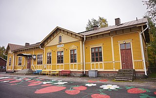
The Hankasalmi railway station is located in the village and urban area of Hankasalmen asemanseutu in the municipality of Hankasalmi, Finland. It is located along the Jyväskylä–Pieksämäki railway, and its neighboring stations are Jyväskylä in the west and Pieksämäki in the east.

The Finnish national road 23 is a highway between Western and Eastern Finland that runs between the cities of Pori and Joensuu via Jyväskylä. The length of the road is 517 kilometres (321 mi). The road is also called the Finnish Lake Road, as it runs through the Finnish Lakeland area in the central hinterland of the country.


