
Seram is the largest and main island of Maluku province of Indonesia, despite Ambon Island's historical importance. It is located just north of the smaller Ambon Island and a few other adjacent islands, such as Saparua, Haruku, Nusa Laut and the Banda Islands.

Saparua is an island east of Ambon Island in the Indonesian province of Maluku; the island of Haruku lies between Saparua and Ambon. The main port is in the south at Kota Saparua. The small island of Maolana is located near its southwestern side and Nusa Laut off its southeastern tip.

South Maluku, also South Moluccas, officially the Republic of South Maluku, is a former unrecognised secessionist republic that originally claimed the islands of Ambon, Buru, and Seram, which currently make up most of the Indonesian province of Maluku.

The Molucca Sea is located in the western Pacific Ocean, around the vicinity of Indonesia, specifically bordered by the Indonesian Islands of Celebes (Sulawesi) to the west, Halmahera to the east, and the Sula Islands to the south. The Molucca Sea has a total surface area of 77,000 square miles. The Molucca Sea is rich in coral and has many diving sites due to the deepness of its waters. The deepness of the water explains the reasoning behind dividing the sea into three zones, which functions to transport water from the Pacific Ocean to the shallower seas surrounding it. The deepest hollow in the Molucca Sea is the 15,780-foot (4,810-meter) Batjan basin. This region is known for its periodic experiences of earthquakes, which stems from the sea itself being a micro plate, in which the Molucca Sea is being subducted in two opposite directions: one in the direction of the Eurasian Plate to the west and the other in the direction of the Philippine Sea Plate to the east.
Paperu, Indonesia, is a village on the island of Saparua, which is a part of the Ambon island group in the Maluku Islands.
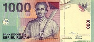
Thomas Matulessy, also known as Kapitan Pattimura or simply Pattimura, was a famous Ambonese soldier who became a symbol of both the Maluku and Indonesian struggle for independence, praised by President Sukarno and declared a national hero by President Suharto. He has several namesakes in both the Netherlands and in the Indonesian archipelago.
The Piru Bay languages are a group of twenty Malayo-Polynesian languages, spoken on Ambon Island and around Piru Bay on the island of Seram, Indonesia. None of the languages have more than about twenty thousand speakers, and several are endangered with extinction.

Central Maluku Regency is a regency of Maluku Province of Indonesia. The Regency covers an area of 11,595.57 km2, and had a population of 361,698 at the 2010 Census, and 423,094 at the 2020 Census. The official estimate as at mid 2023 was 430,798. The principal town lies at Masohi, on Seram Island. The regency (kebupaten) is composed of the central part of the island of Seram, the Banda Islands, and the Lease Islands, together with those parts of Ambon Island which are outside the City of Ambon.
The Kingdom of Iha was an Islamic kingdom located in Saparua island, Maluku. Around the Dutch colonial period, there existed two well-known kingdoms in Saparua island, Iha and Honimoa. Both were quite influential Islamic empires known as sapanolua. This means two boat or two boats. It means Saparua island has two large peninsula thereon two ruling kings controlling a vast land. While the southeast peninsula was controlled by the King of Honimoa with his kingdom, the north peninsula was the regional power of the Kingdom of Iha. The Kingdom of Iha was involved in a series of struggles against the Dutch colonization of Maluku that later led to the Iha War (1632-1651) which resulted in a loss of some areas of this kingdom as well as its citizens which led to the later deterioration of the kingdom.
Masohi is a coastal town on the Indonesian island of Seram. It is the capital of the Central Maluku Regency. It was the site of a detention camp for political prisoners in the 1970s. It had 36,433 inhabitants at the 2020 census. The headquarters of Manusela National Park is located in Masohi.

Haruku Island is an island in Central Maluku Regency, Maluku Province, Indonesia - lying east of Ambon Island, off the southern coast of Seram and just west of Saparua. It is administered as a single district, Haruku Island District, with a land area of 150 km2 and a population of 24,207 at the 2010 census and 27,390 at the 2020 Census; the official estimate as at mid 2023 was 26,551. The inhabitants of Haruku speak the Haruku language, as well as Indonesian and Ambonese Malay.
Nusa Laut is the smallest inhabited island in the Lease Islands group east of Ambon, in Indonesia's Maluku province. It lies just off the south-western corner of Saparua island, separated from it by a deep channel. The island's coasts are fringed by a drying reef.

The Lease Islands, formerly called the Uliasers or Uliassers, are a group of three inhabited islands, lying immediately to the south of Seram and east of Ambon Island in the province of Maluku, in Indonesia. The three inhabited islands, from west to east, are Haruku, Saparua and Nusa Laut, while tiny uninhabited Molana is administratively part of Saparua District; these islands constitute four administrative districts (kecamatan) within Central Maluku Regency.
Saparua is an Austronesian language spoken in Maluku of eastern Indonesia. Dialects are diverse, and Latu might be included as one. Saparua is currently spoken by around 1,500 people, and it is threatened by extinction. According to a researcher from the National Research and Innovation Agency, Khairunnisa, stated that this is caused by the influences of Dutch colonialism, the sectarian conflict, migration, globalization, and the duty to speak Indonesian.

Ullath is one of 18 villages on the island of Saparua in the province of Maluku, Indonesia. Ullath situated on the southeastern peninsula of Saparua along with Siri-sori Amalatu, Siri-sori Amapatti, and Ouw. It is most known for its cloves, fish, and sago. The current raja is Abraham Nikijuluw.

Manipa Island is an island in West Seram Regency, Maluku Province, Indonesia. It is located 8 km off the western coast of Kelang at the western end of Seram Island and 25 km off the western coast of Buru. Including adjacent small islands, it covers an area of 159.71 km2. The inhabitants speak the Manipa language, as well as Indonesian and Ambonese Malay.

Fort Duurstede is a 17th-century colonial Dutch fort in Saparua, Indonesia The fort originally protected Saparoea village. A navigation guide from 1878 advises: "There is good anchorage near this fort in the westerly monsoon in about 12 fathoms."

Johanis Hermanus Manuhutu was a South Moluccan civil servant in the Dutch East Indies and the first president of the Republic of South Maluku in 1950.