
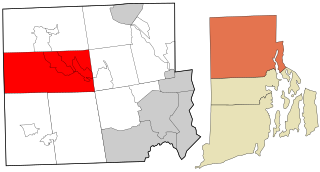
Burrillville is a town in Providence County, Rhode Island, United States. The population was 16,158 at the 2020 census.
Glocester is a town in Providence County, Rhode Island, United States. The population was 9,974 as of the 2020 census. The villages of Chepachet and Harmony are in Glocester. Putnam Pike runs west through the town center of Glocester into Putnam, Connecticut.
The Ponaganset River is a river in the U.S. state of Rhode Island. It flows approximately 12.5 miles (20.1 km). There are three dams along the river's length.
The Pascoag River is a river in the U.S. state of Rhode Island. It flows approximately 4.5 miles (7 km). There are five dams along the river's length.

Harmony is a village and census-designated place in Providence County, Rhode Island, in the town of Glocester, located on U.S. Route 44. As of the 2010 census, it had a population of 985.
Ironstone is an historic village,, in the township of Uxbridge, Massachusetts, United States. It derived its name from plentiful bog iron found here which helped Uxbridge to become a center for three iron forges in the town's earliest settlement. South Uxbridge has historic sites, picturesque weddings, hospitality, industrial and distribution centers, and the new Uxbridge High School. This community borders North Smithfield, and Burrillville, Rhode Island, and Millville, Massachusetts. South Uxbridge receives municipal services from Uxbridge, for fire, police, EMS, School district, public works, and other services. There is a South Uxbridge fire station of the Uxbridge fire department. Worcester's Judicial District includes Uxbridge District Court. Ironstone appears on the Blackstone U.S. Geological Survey Map. Worcester County is in the Eastern time zone and observes DST.
Carolina is a village that straddles the border of the towns of Charlestown and Richmond on the Pawcatuck River in Washington County, Rhode Island. Rhode Island Route 112 passes through the village. Carolina is identified as a census-designated place, with a population of 970 at the 2010 census.

Juniper Hill Cemetery is a historic cemetery at 24 Sherry Avenue in Bristol, Rhode Island founded by George R.Usher, James D'Wolf Perry, Byron Diman, Ambrose E. Burnside, James H. West, Charles H. R. Doringle, and Lemanuel W. Briggs. The original 22 acres (89,000 m2) were purchased from the descendants of Levi DeWolf, a local farmer and slave hauler, in 1855, and the cemetery corporation that owns it was chartered in January 1856. It is a fine example of the mid-19th century rural cemetery movement, with winding lanes and paths. The landscape was designed by Niles Bierragaard Schubarth, who had done similar work at other Rhode Island cemeteries. Its main entry is a massive stone gate built in 1876, and there is a gate house just inside, designed by Clifton A. Hall and constructed from granite quarried on site.

The Portsmouth Friends Meetinghouse, Parsonage, and Cemetery is a historic Friends Meeting House and cemetery of the Religious Society of Friends (Quakers), at 11 Middle Road and 2232 E. Main Road in Portsmouth, Rhode Island.

The Newman Cemetery is an historic cemetery in East Providence, Rhode Island. One of the oldest in the state, the cemetery was established in 1643, when the area was part of Rehoboth, Massachusetts. It is located at the southwest corner of Newman and Pawtucket Avenues, adjacent to the Newman Congregational Church. Its first recorded burial is in 1658, and it remained in use well into the 19th century.

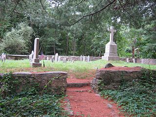
The Indian Burial Ground is a historic Native American cemetery on Narrow Lane in Charlestown, Rhode Island. The small cemetery is believed to have been the burying ground for leaders of the Narragansett and Niantic tribes. It is now fenced off by an iron post and rail fence, erected in the late 19th century.
The Old Narragansett Cemetery is an historic cemetery on Shermantown Road in North Kingstown, Rhode Island. Variant names for the cemetery include Narragansett Cemetery, Platform Cemetery, and The Platform Cemetery. The cemetery occupies a 1.2 acres (0.49 ha) plot about 300 feet (91 m) south of Shermantown Road, roughly midway between its two junctions with Mourning Dove Drive. It was established early in the 18th century, and is one of North Kingstown's oldest and longest-used cemeteries. It has 110 marked graves, and was used from its establishment c. 1705 to the 1880s. The most prominent memorials are to James MacSparran and Samuel Fayerweather, two long-serving ministers at the Old Narragansett Church, which stood nearby when it was built in 1706.
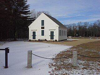
West Greenwich Baptist Church and Cemetery is a historic church meeting house and cemetery at Plain Meeting House and Liberty Hill Roads in West Greenwich Center, Rhode Island. It is the oldest building of this type in the western edge of Rhode Island.

St. Mary's Church and Cemetery is a historic Roman Catholic church building and cemetery in Crompton, a village of West Warwick, Rhode Island.

Riverside Cemetery is an historic cemetery at 752 Pleasant Street in Pawtucket, Rhode Island. It occupies a parcel of land about 34 acres (14 ha) in size between Pleasant Street and the Seekonk River, and just north of the much larger Swan Point Cemetery in neighboring Providence. The cemetery was established in 1874, and is Pawtucket's instance of a rural cemetery.

Providence Quaker Cemetery and Chapel, also known as Providence Meeting House, is a historic chapel and cemetery located on Quaker Church Road about 2 miles southwest of Perryopolis, Fayette County, Pennsylvania. The cemetery was used by Quakers, but the chapel is not a Quaker structure. Quakers generally refer to a structure built for worship as a meeting house, rather than as a chapel or church.

Foster Center is a village in the town of Foster, Rhode Island, United States. It was listed as a census-designated place (CDP) in 2010, with a population of 355. Historic elements of the village are included in the Foster Center Historic District, which was added to the National Register of Historic Places on May 11, 1974. The district features various colonial and Greek Revival houses as well as the still functioning town building from the late 18th century.

Chepachet is a village and census-designated place (CDP) in the town of Glocester in the northwestern part of the U.S. state of Rhode Island. It is centered at the intersection of U.S. Route 44 and Rhode Island Route 102. Chepachet's ZIP code is 02814. As of the 2010 census, the CDP had a population of 1,675.

Hopkins Hollow Village is an historic district along Hopkins Hollow Road, Narrow Lane, and Perry Hill Road in Coventry, Rhode Island, United States, and West Greenwich, Rhode Island.

Anthony is a village along Route 117 within the town of Coventry, Rhode Island near the villages of Washington and Quidnick on the southwestern banks of the Pawtuxet River. The village comprises "Anthony, Arnold, Boston, Mapledale, Meeting, Taft, Washington and Laurel Avenue."


