Related Research Articles

The Potomac River drains the Mid-Atlantic United States, flowing from the Potomac Highlands into Chesapeake Bay. It is 405 miles (652 km) long, with a drainage area of 14,700 square miles (38,000 km2), and is the fourth-largest river along the East Coast of the United States and the 21st-largest in the United States. Over 5 million people live within its watershed. There is a hydroelectric plant on the river constructed in 2014 by Dominion.
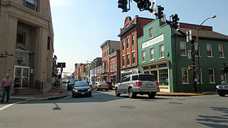
Leesburg is the county seat of Loudoun County, Virginia. It was built in 1740 and is named for the Lee family, early leaders of the town and ancestors of Robert E. Lee. In the War of 1812, it was a refuge for important federal documents evacuated from Washington, DC, and in the Civil War, it changed hands several times.

The Potomac Company was created in 1785 to make improvements to the Potomac River and improve its navigability for commerce. The project is perhaps the first conceptual seed planted in the minds of the new American capitalists in what became a flurry of transportation infrastructure projects, most privately funded, that drove wagon road turnpikes, navigations, and canals, and then as the technology developed, investment funds for railroads across the rough country of the Appalachian Mountains. In a few decades, the eastern seaboard was crisscrossed by private turnpikes and canals were being built from Massachusetts to Illinois ushering in the brief seven decades of the American Canal Age. The Potomac Company's achievement was not just to be an early example, but of being significant also in size and scope of the project, which involved taming a mountain stream fed river with icing conditions and unpredictable freshets (floods).
The Potomac Heritage Trail, also known as the Potomac Heritage National Scenic Trail or the PHT, is a designated National Scenic Trail corridor spanning parts of the mid-Atlantic region of the United States that will connect various trails and historic sites in Virginia, Maryland, Pennsylvania, and the District of Columbia. The trail network includes 710 miles (1,140 km) of existing and planned sections, tracing the natural, historical, and cultural features of the Potomac River corridor, the upper Ohio River watershed in Pennsylvania and western Maryland, and a portion of the Rappahannock River watershed in Virginia. The trail is managed by the National Park Service.

The Battle of Monocacy was fought on July 9, 1864, approximately 6 miles (9.7 km) from Frederick, Maryland, as part of the Valley Campaigns of 1864 during the American Civil War. Confederate forces under Lt. Gen. Jubal A. Early defeated Union forces under Maj. Gen. Lew Wallace. The battle was part of Early's raid through the Shenandoah Valley and into Maryland in an attempt to divert Union forces away from Gen. Robert E. Lee's army under siege at Petersburg, Virginia.

The Battle of Ball's Bluff was an early battle of the American Civil War fought in Loudoun County, Virginia, on October 21, 1861, in which Union Army forces under Major General George B. McClellan suffered a humiliating defeat.

Charles Pomeroy Stone was a career United States Army officer, civil engineer, and surveyor. He fought with distinction in the Mexican–American War, earning two brevet promotions for his performance in the conflict. After resigning and surveying for the Mexican Government, he returned to the U.S. Army to fight in the American Civil War.
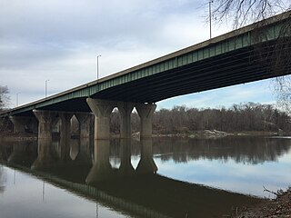
The American Legion Memorial Bridge, also known as the American Legion Bridge and formerly as the Cabin John Bridge, is a bridge carrying Interstate 495 across the Potomac River between Montgomery County, Maryland and Fairfax County, Virginia in the United States. It is an American Water Landmark. Plummers Island is located immediately downstream of the bridge.
NOVA Parks is an inter-jurisdictional organization that owns and operates more than 10,000 acres of woodlands, streams, parks, trails, nature reserves, countryside and historic sites in Northern Virginia in the United States. The Authority was organized in 1959. NOVA Parks presently operates 33 regional parks.
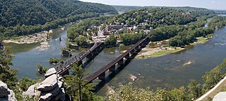
Harpers Ferry National Historical Park, originally Harpers Ferry National Monument, is located at the confluence of the Potomac and Shenandoah rivers in and around Harpers Ferry, West Virginia. The park includes the historic center of Harpers Ferry, notable as a key 19th-century industrial area and as the scene of John Brown's failed abolitionist uprising. It contains the most visited historic site in the state of West Virginia, John Brown's Fort.
The Potomac Highlands of West Virginia centers on five West Virginian counties in the upper Potomac River watershed in the western portion of the state's Eastern Panhandle, bordering Maryland and Virginia. Because of geographical proximity, similar topography and landscapes, and shared culture and history, the Potomac Highlands region also includes Pocahontas, Randolph, and Tucker counties, even though they are in the Monongahela River or New River watersheds and not that of the Potomac River.

Great Falls is a series of rapids and waterfalls on the Potomac River, 14 miles (23 km) upstream from Washington, D.C., on the border of Montgomery County, Maryland and Fairfax County, Virginia. Great Falls Park, managed as part of George Washington Memorial Parkway, is on the southern banks in Virginia, and Chesapeake and Ohio Canal National Historical Park parkland is along the northern banks of the river in Maryland. Both are operated by the National Park Service. The Potomac and the falls themselves are legally entirely within Maryland, with the state and county boundaries following the south bank of the river.
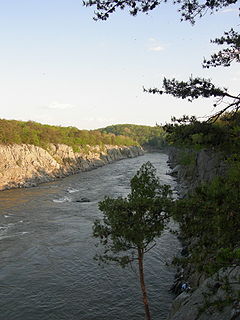
Mather Gorge is a river gorge south and just downriver of Great Falls in the state of Maryland bordering Virginia. The Maryland land side of the gorge is Bear Island, part of the Chesapeake and Ohio Canal National Historical Park, and the Virginia side is part of Great Falls Park. Both parks are National Park Service sites. The gorge is named after Stephen Mather, the first director of the National Park Service.
Chaffin's Bluff is located in Henrico County, Virginia, United States, on the north side of the James River, opposite Drewry's Bluff, long-considered a major defense point of the river below Richmond. Located at a major bend in the river about eight miles south of Richmond, both bluffs were fortified by the Confederates early in the American Civil War.
Loudoun County, Virginia, was destined to be an area of significant military activity during the American Civil War. Located on Virginia's northern frontier, the Potomac River, Loudoun County became a borderland after Virginia's secession from the Union in early 1861. Loudoun County's numerous Potomac bridges, ferries and fords made it an ideal location for the Union and Confederate armies to cross into and out of Virginia. Likewise, the county's several gaps in the Blue Ridge Mountains that connected the Piedmont to the Shenandoah Valley and Winchester were of considerable strategic importance. The opposing armies would traverse the county several times throughout the war leading to several small battles, most notably the Battle of Balls Bluff.

Erasmus R. Burt was an American physician, politician, and soldier. He served as the State Auditor of Mississippi, and was then a member of the Mississippi House of Representatives. During the American Civil War, he was a colonel in the Confederate States Army and was killed in action at the Battle of Ball's Bluff in Northern Virginia. He was known as “the Father of the Deaf and Dumb Institute of Mississippi”.
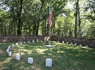
Ball's Bluff Battlefield Regional Park and National Cemetery is a battlefield area and a United States National Cemetery, located 2 miles (3.2 km) northeast of Leesburg, Virginia. The cemetery is the third smallest national cemetery in the United States. Fifty-four Union Army dead from the Battle of Ball's Bluff are interred in 25 graves in the half-acre plot; the identity of all of the interred except for one, James Allen of the 15th Massachusetts, are unknown. Monuments to fallen Confederate Sergeant Clinton Hatcher and Union brigade commander Edward Dickinson Baker are located next to the cemetery, though neither is buried there. While the stone wall-enclosed cemetery itself is managed through the Culpeper National Cemetery and owned by the Department of Veterans Affairs, the balance of the 223-acre (0.90 km2) park is managed through the Northern Virginia Regional Park Authority.

The 15th Massachusetts Volunteer Infantry Regiment was an infantry regiment that served from the State of Massachusetts during the American Civil War from 1861–1864. A part of the II Corps of the Army of the Potomac, the regiment was engaged in many battles from Ball's Bluff to Petersburg, and suffered the tenth highest fatality rate amongst Federal regiments. The regiment was composed almost entirely of men from Worcester County, and was mustered in on July 12, 1861.

The Battle of Malvern Hill, also known as the Battle of Poindexter's Farm, was fought on July 1, 1862, between the Confederate Army of Northern Virginia, led by Gen. Robert E. Lee, and the Union Army of the Potomac under Maj. Gen. George B. McClellan. It was the final battle of the Seven Days Battles during the American Civil War, taking place on a 130-foot (40 m) elevation of land known as Malvern Hill, near the Confederate capital of Richmond, Virginia and just one mile (1.6 km) from the James River. Including inactive reserves, more than fifty thousand soldiers from each side took part, using more than two hundred pieces of artillery and three warships.
Seneca Dam was the last in a series of dams proposed on the Potomac River in the area of the Great Falls of the Potomac. Apart from small-scale dams intended to divert water for municipal use in the District of Columbia and into the Chesapeake and Ohio Canal, no version of any scheme was ever built. In most cases the proposed reservoir would have extended upriver to Harpers Ferry, West Virginia. The project was part of a program of as many as sixteen major dams in the Potomac watershed, most of which were never built.
References
- ↑ "Potomac River Sojourn: An Island Dream". Voice of America. 2009-10-27.